In general, the TI units are faster in response to inputs. This is seen when quickly switching between sonar, downscan, chart, and split screens ruclips.net/user/postUgkxeAxH15LxhjGlg5-CRYqjTGTEH0tbY4vk recommend The Hook units will show some lag on button pushes and screen switching. The big ticket item though is maps. If you install a mapping card such as Navionics or the free C-Map Genesis which has a lot of map detail, then moving around the map with the cursor or when running down the lake can lag significantly on the Hook units, but is seamless with the TI units.
Thank you for the videos! Just bought an Echomap uhd93sv gt56. Was excited to get it and what it can do and after watching your videos I definitely bought the right unit over Humminbird Helix.
I have a Echomap Combo Pluss 65CV Unit in my boat. How do i create a Track that i will make and record it for a later date. I will be navigating a route thru and area of shallow water that i will need for the future to come back on. Please help
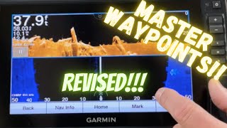
One thing to add and expand on to help others so they don't do what I have been doing. When you put the cursor on the brushpile/rocks/structure/whatever you want to mark, DO NOT PRESS THE MARK BUTTON. Make sure to press the CURSOR tear drop button that he shows in the video in the upper right of screen. IF you are MOVING and going over a brush pile, for example, and you pause the screen, put the cursor on the brushpile, BUT ARE STILL MOVING when you press the MARK button, you will create a waypoint WHERE YOU ARE AT THAT MOMENT and NOT mark the brushpile. And later when you try to find it, like me, IT WILL NOT BE WHERE YOUR WAYPOINT MARKER SAYS IT IS. It could be 20-100 feet away, depending on how far past it you went when you hit the MARK button. In the video when he set a waypoint (:26 mark) and named it Baitball (:41 mark) HE WILL NEVER BE ABLE TO GO BACK AND FIND THAT BAITBALL because his boat was moving when he pressed the MARK button. When you make a waypoint and you press the MARK button you will see in the upper left (:31 mark in this video) Waypoint Created at Boat. When creating a waypoint and you press the cursor button, (at 1:51 in this video) it will say Waypoint Created at CURSOR The most important time when marking a waypoint to use the CURSOR tear drop button is when you are marking a waypoint in SIDEVIEW. IF you pause the screen when you find a brushpile in SIDEVIEW, put cursor on it and press MARK, you could be 20-50 feet away (or further depending on how far the brushpile is away from your transducer) TO THE LEFT OR RIGHT OF YOUR TRANSDUCER. Take it from me, because I did it several times today, YOU WILL NEVER FIND THAT WAYPOINT IN DOWNVIEW when you go back because you could be again, 20-50 feet or more away from it because you marked it where your boat was at the time you pressed the MARK button. I know in the video he explains to press the cursor button, and I don't mean to come on his channel and give advice, but it is misleading when he marks the "baitball" by pressing the MARK button. And up until today I have always marked a brushpile by pressing the MARK button and would get frustrated as h*ll when I couldn't find it later. So hopefully this helps somebody else who couldn't find their brushpiles. Now to go back and re mark the 100 or so brushpiles and structures I have saved over this last year :(
Yes the first waypoint I make is just a example on how to name it etc. When it comes to marking a waypoint accurately on side imaging you actually shouldn’t put to cursor on the “mark” off to the side… You need to lead it towards the center for it to be accurate. I will do a video on this eventually
@@MGMarineTech "When it comes to marking a waypoint accurately on side imaging you actually shouldn’t put to cursor on the “mark” off to the side… You need to lead it towards the center for it to be accurate. I will do a video on this eventually" My point wasn't WHERE to put the cursor when marking something. My point was when you put the cursor on an object NOT to press MARK but to press the Cursor button to make sure you accurately mark WHERE the object is
Thank you for the great videos! Is there a way to save waypoints so that they show back up on side imaging when you go back to spots that you have marked previously, or do they only show up in map view?
An ActiveCaptain video is on the way. Unfortunately I don’t have a autopilot to make videos on at the moment. But if i get one I will be sure to make a video!
After you create a waypoint and circling back around to it. My Transducer is on the transom starboard side. My one and only unit a 93UHDSV with a 56 transducer, unit is on console approx. 8-10 feet in front of transducer. When you start driving towards the "X" for the brush pile, and you have it zoomed in to the max. Say 20' from the X. It shows the little boat symbol on the screen as you head towards the x. Is the X 20' from the transducer? Or is the X 20' from the unit on the console? So when i am trolling to the X and lets say i want to be 40 ' from the X with the Bow of my boat, am i measuring from the bow or console or transducer?TIA
Max-Does Garmin allow casting rings or other boundaries, so you can position your boat out from and cast to the exact waypoint structure? I couldn't find that anywhere...Thanks!
is there a way to store waypoints in say a "folder" for different places you fish. So say you fish a certain river can you have way points for that and load them up and then you go to a lake and have waypoints for that or does it do it all by gps positioning?
That one I’m not sure on.. these units will store 5000 waypoints. So assuming you will only need those waypoints when you are on that body of water I’m not sure why you would need to separate them but I am always open to hear how others do things. That being said you can assign different symbols to waypoints and are able to sort by them.
@@MGMarineTech thanks man love you detailed videos. I just bought a 73sv with GT54 and have not even installed it yet. I will use all of your settings as soon as i get it installed
I think that is going to be my next video. I will show how to use the QuickDraw contours and how to map a lake or body of water that doesn’t have mapping or isn’t accurate.
@@MGMarineTech I have a question for you when mapping do you need a seperate sd card for each lake or can you load more then one map on a card. if so what size card should I use ?
I’m sure there is. But I’m not sure what it would be. I would imagine you would have to find a way to export them to from the lowrance to a second card. You could then take them into home port and make them work with garmin.
How do I change the waypoint numbers in my garmin from numbers to the names? These were already included in the software. We are familiar with the names of certain waypoints in our area but they are showing numbers 🤦♀️
If you click on the waypoint it should bring up a menu to allows you to do a couple of things. One of those options should be “edit waypoint” or something along those lines. Once you are in that menu, you should be able to edit the name/number
I wish these were as user friendly as lowrance. You can tap anywhere on the screen, press the waypoint key and then press the x button to continue. Garmin takes up the whole screen and you lose a good 5-10 seconds of screen viewing. Same with taking a screenshot.


In general, the TI units are faster in response to inputs. This is seen when quickly switching between sonar, downscan, chart, and split screens ruclips.net/user/postUgkxeAxH15LxhjGlg5-CRYqjTGTEH0tbY4vk recommend The Hook units will show some lag on button pushes and screen switching. The big ticket item though is maps. If you install a mapping card such as Navionics or the free C-Map Genesis which has a lot of map detail, then moving around the map with the cursor or when running down the lake can lag significantly on the Hook units, but is seamless with the TI units.
Very good video, I just thought I knew my unit but you showed stuff I had no clue about. Thanks for the upload!
Thanks for the great information! Very helpful GOD BLESS
What great information. Keep sharing tips for Garmins. I can’t wait to try out what you shared once I get out on the water.
Your good!!! Keep those videos coming. Thank you.
Thank you! I sure will!
You are a great teacher of this device. Thanks 👍🏼😎👍🏼
Excellent. Lovin my garmin every time I learn a new feature
Awesome tutorial, please keep making for informative and tips and tricks content! Subscribed!
Thanks for the share! Very helpful.
Very nice. Straight to the point and easy instructions, thanks for sharing.
Very helpful. Thanks. I like your mellow and clear message delivery. Looking forward to using my 2 new Garmin UHD 95SV. Cheers !
Very informative! Thanks! I just installed a 73SV UHD on my fishing pontoon.
Thank you for the videos! Just bought an Echomap uhd93sv gt56. Was excited to get it and what it can do and after watching your videos I definitely bought the right unit over Humminbird Helix.
Great information!! Thank you! I have a sv93 uhd, been looking for this information for a while!! Keep putting out good tips👍👍
Thanks mate. That helped a lot.
Great video Max!
Good info. Thanks for the tips.
Very good video! Keep them coming!
Awesome thanks bud much help sailing in new 106 got 2 of those and a 93 uhd networked got to get dailed in
Cool info very helpful
I will use that info, thanks 👍
Amazing video. That really helped a lot.
Great info. Thanks.
Great video. Coming from another brand you answered all my questions.
Great video.
Great video!!
You the man!!!
Very good news.
Thanks for intro. Would you please explain how to read the various data, starting with depth finder. I'm new to this all and it's unclear. Thanks.
Good video. Quick and concise. What model do you have?
Thank you! The unit in this video is a 126sv ultra. But these tips should work on most garmin units.
I have a Echomap Combo Pluss 65CV Unit in my boat. How do i create a Track that i will make and record it for a later date. I will be navigating a route thru and area of shallow water that i will need for the future to come back on. Please help
One thing to add and expand on to help others so they don't do what I have been doing.
When you put the cursor on the brushpile/rocks/structure/whatever you want to mark, DO NOT PRESS THE MARK BUTTON. Make sure to press the CURSOR tear drop button that he shows in the video in the upper right of screen.
IF you are MOVING and going over a brush pile, for example, and you pause the screen, put the cursor on the brushpile, BUT ARE STILL MOVING when you press the MARK button, you will create a waypoint WHERE YOU ARE AT THAT MOMENT and NOT mark the brushpile. And later when you try to find it, like me, IT WILL NOT BE WHERE YOUR WAYPOINT MARKER SAYS IT IS. It could be 20-100 feet away, depending on how far past it you went when you hit the MARK button.
In the video when he set a waypoint (:26 mark) and named it Baitball (:41 mark) HE WILL NEVER BE ABLE TO GO BACK AND FIND THAT BAITBALL because his boat was moving when he pressed the MARK button.
When you make a waypoint and you press the MARK button you will see in the upper left (:31 mark in this video) Waypoint Created at Boat.
When creating a waypoint and you press the cursor button, (at 1:51 in this video) it will say Waypoint Created at CURSOR
The most important time when marking a waypoint to use the CURSOR tear drop button is when you are marking a waypoint in SIDEVIEW. IF you pause the screen when you find a brushpile in SIDEVIEW, put cursor on it and press MARK, you could be 20-50 feet away (or further depending on how far the brushpile is away from your transducer) TO THE LEFT OR RIGHT OF YOUR TRANSDUCER. Take it from me, because I did it several times today, YOU WILL NEVER FIND THAT WAYPOINT IN DOWNVIEW when you go back because you could be again, 20-50 feet or more away from it because you marked it where your boat was at the time you pressed the MARK button.
I know in the video he explains to press the cursor button, and I don't mean to come on his channel and give advice, but it is misleading when he marks the "baitball" by pressing the MARK button. And up until today I have always marked a brushpile by pressing the MARK button and would get frustrated as h*ll when I couldn't find it later. So hopefully this helps somebody else who couldn't find their brushpiles. Now to go back and re mark the 100 or so brushpiles and structures I have saved over this last year :(
Yes the first waypoint I make is just a example on how to name it etc.
When it comes to marking a waypoint accurately on side imaging you actually shouldn’t put to cursor on the “mark” off to the side…
You need to lead it towards the center for it to be accurate. I will do a video on this eventually
@@MGMarineTech "When it comes to marking a waypoint accurately on side imaging you actually shouldn’t put to cursor on the “mark” off to the side…
You need to lead it towards the center for it to be accurate. I will do a video on this eventually"
My point wasn't WHERE to put the cursor when marking something. My point was when you put the cursor on an object NOT to press MARK but to press the Cursor button to make sure you accurately mark WHERE the object is
@@drjaywhitlock yes and I cover this in the video…
Mark is where the boat is,
Top right rear drop put it where the cross hairs are.
Can you explain how to delete previous navigation routes on fishing chart screen? Thanks
Thank you for the great videos! Is there a way to save waypoints so that they show back up on side imaging when you go back to spots that you have marked previously, or do they only show up in map view?
Map view
When u hit the mark button you can’t tell what u mark like the other ways u showed is that correct
When you hit the “mark” button it will make a waypoint wherever the boat is at at that exact time. And it will be directly on your track line
Do you think you can make a video showing us how to use the active captain and also how to get you reactor 40 autopilot to follow you way points.
An ActiveCaptain video is on the way.
Unfortunately I don’t have a autopilot to make videos on at the moment. But if i get one I will be sure to make a video!
After you create a waypoint and circling back around to it. My Transducer is on the transom starboard side. My one and only unit a 93UHDSV with a 56 transducer, unit is on console approx. 8-10 feet in front of transducer. When you start driving towards the "X" for the brush pile, and you have it zoomed in to the max. Say 20' from the X. It shows the little boat symbol on the screen as you head towards the x. Is the X 20' from the transducer? Or is the X 20' from the unit on the console? So when i am trolling to the X and lets say i want to be 40 ' from the X with the Bow of my boat, am i measuring from the bow or console or transducer?TIA
The waypoint is made at the unit not the transducer.
Also keep in mind civilian gps is only so accurate. 4-10’ give or take.
Max-Does Garmin allow casting rings or other boundaries, so you can position your boat out from and cast to the exact waypoint structure? I couldn't find that anywhere...Thanks!
There is a feature that is similar I’ll have to dig into it as I have never used it myself. But I will see what I can come up with
Garmin doesn't have casting rings.
is there a way to store waypoints in say a "folder" for different places you fish. So say you fish a certain river can you have way points for that and load them up and then you go to a lake and have waypoints for that or does it do it all by gps positioning?
That one I’m not sure on.. these units will store 5000 waypoints. So assuming you will only need those waypoints when you are on that body of water I’m not sure why you would need to separate them but I am always open to hear how others do things.
That being said you can assign different symbols to waypoints and are able to sort by them.
🙂 👍🏻👍🏻
Which map are you using in the left bottom? I have the side view on top as you showed in a previous video and the clear vu on the bottom right.
I always use the fishing chart
@@MGMarineTech thanks for the info. Somehow mine looks different than yours. Probably just me. LOL
Is there a history on the down image like you showed for the side?
Yes there is a history for all the sonars.
About 3 screens worth.
@@MGMarineTech can i manually enter GPS coordinates
@@cajunman7389 yes you can
@@MGMarineTech thanks man love you detailed videos. I just bought a 73sv with GT54 and have not even installed it yet. I will use all of your settings as soon as i get it installed
I,m learning something . Thanks how about mapping a lake have any thing on that ?
I think that is going to be my next video. I will show how to use the QuickDraw contours and how to map a lake or body of water that doesn’t have mapping or isn’t accurate.
@@MGMarineTech I have a question for you when mapping do you need a seperate sd card for each lake or can you load more then one map on a card. if so what size card should I use ?
You can map as many lakes that will fit on a sd card
The maximum size is 32gb
how did you get the screen with the depths how did you set that up step by step
Which screen are you referring to?
Could you tell me at what time in the video?
Is there a way to import waypoints from my lowrance hds? I have a Garnin 93SV on the way.
I’m sure there is. But I’m not sure what it would be.
I would imagine you would have to find a way to export them to from the lowrance to a second card. You could then take them into home port and make them work with garmin.
What settings do you use to track your drop shot as it falls under the boat?
Are you talking about livescope settings
@@MGMarineTech No, just just 2D sonar...Thanks for the reply
What area are from?
How do I change the waypoint numbers in my garmin from numbers to the names? These were already included in the software. We are familiar with the names of certain waypoints in our area but they are showing numbers 🤦♀️
If you click on the waypoint it should bring up a menu to allows you to do a couple of things.
One of those options should be “edit waypoint” or something along those lines.
Once you are in that menu, you should be able to edit the name/number
@@MGMarineTech the problem is we know the names of the ones we’ve been to but don’t know which numbers they are associated with 😞
@@tinaharlow4508 can you look at your tracks? And see where you stopped
@@MGMarineTech we bought this boat used recently and are on it for the first time today. We have a card in our other boat with the waypoints named.
My unit does not have the “pause” button on the screen. How do I get that Ouse button to appear?
What unit do you have?
I’ve not come across this issue..
@@MGMarineTech 73sv
Is it a touch screen “plus” model?
@@MGMarineTech yes it is.
I would try a factory reset
HOW DO YOU GET A SPLIT SCREEN LIKE THIS
You use the combos feature or make your own custom combo
Do i need a Bluechart g3 card te make these waypoints?
No, you should be able to make waypoints on any map
@@MGMarineTech thanks! Will try 🙌🏼
I wish these were as user friendly as lowrance. You can tap anywhere on the screen, press the waypoint key and then press the x button to continue. Garmin takes up the whole screen and you lose a good 5-10 seconds of screen viewing. Same with taking a screenshot.