Google Earth Contours vs LiDAR (How to Extract Contours from Google Earth and How they Compare)

HTML-код
- Опубликовано: 10 июл 2024
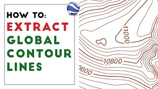
- In this video, we show you how to extract contours using Google Earth, GPS Visualizer, and QGIS and how they compare to contours created from lidar data. We use the Equator platform to source free, public lidar data in the US and generate contours directly from the information on the fly.
***The Equator user interface has been updated.**** Check out this video to learn more:
• Site Builder Overview
Or just try it and see for yourself today: maps.equatorstudios.com/?entr...
General information about Equator: equatorstudios.com/
The video will answer the following questions:
0:11 How to generate contours from Google Earth?
1:03 Using GPS Visualizer.
1:30 Creating contours from points in QGIS
3:05 Creating contours from USGS lidar using Equator
3:35 Viewing USGS lidar point clouds using Equator
4:25 Visual comparison of contour accuracy
5:40 Detailed comparison of different cross-sections in Excel
Keywords: Google Earth, contours, topography, lidar, USGS, point cloud, Equator
If you liked this video, you may also like:
Where to find LiDAR data online? (USGS lidar point cloud in Equator) • Where to find LiDAR da...
How to create smooth contours in Civil 3D from lidar • How to create smooth c...
How do I create a surface in AutoDesk Civil 3D from a LiDAR Point Cloud (.laz)? • How do I create a surf...
How to make your own discoveries using LiDAR data online in Equator • How to make your own d...
How do I create a surface in Civil 3D from GIS data (contours in shapefile format)? • How do I create a surf...
Equator 101: How to find elevation data online • Equator 101: How to fi...
Site Builder Overview • Site Builder Overview
How to create one surface with multiple DEM (digital elevation models) in Civil 3D • How to create one surf...
How do I download USGS LiDAR for CAD using Equator? Featuring Barter Island, AK • How do I download USGS...
Accessing BC LiDAR Online Using Equator • Accessing BC LiDAR Onl...


We are constantly making improvements to our user interface. If the UI in this video doesn't match the current UI of the Equator platform, watch our latest video on extracting data from Equator's newest interface: ruclips.net/video/Ogy6F-Fczac/видео.html
Thank you for the video!
Amazing. I will be using similar visualizations for drone survey vs goog earth resolution in a digital portfolio format. But I will have to include a video presentation. You did this so well.
Madam i like your style of teaching and experience love this
This is amazing! Thanks for providing such a detailed explanation and comparison
Glad it was helpful!
Thank you
WOW! I'm not completely following what you're doing here, but I've been very interested in maps, topo, and lidar. I just searched you tube to see if there's anything I don't know, and obviously there is! Oddly enough the spot you zoomed into is 2 counties north of me in Iowa! On the site I use we just got 2020 lidar color hillshade for my area, which is awesome! It picks up my ATV trails through the timber, even logs lying on the forest floor. I use the maps to help with farm maintenance and also help in my hunt for arrowheads. And it's just neat to explore places I normally wouldn't be able to go.
Glad you're enjoying Equator!
yes super
what version of QGSIS are you using? Thanks
why not use the topo from eaquator studios intead the one from google earth?
Hi, first time to see equator app, just asking is it free and is it cover the entire world? Bcoz sometimes it's only in the US.... thanks
You can access 30 m DEM data anywhere in the world using Equator. The high-resolution lidar is only in the US, some parts of Canada, and New Zealand. Some aspects of the platform are free and other's are paid. You can try everything out for free though!
@@equatorstudios thanks
Okay, im trying to do this but im having issues at the 2:00 when it comes to contour.
did you find a way? Struggling with the same
QGIS has changed their interface and tools in the latest versions. An alternative to the Vector > Contours option is to use the Contour plugin.
good afternoon. Can this technique be used to study the shores of the seas and lagoons? I am interested in the height and slope of the coast. Thanks
I write work along the shores. Can I contact you for help in my direction? I will thank.
@@user-rj3gu4xf6m Yes, it can! Visit our website and try the app. If you need help, use the help chat in the app. Happy mapping!
How do i change my contour interval of LIDAR database on excel
How can I get an elevation profile/cross section like you show in Excel from geotiff LIDAR data?
Once you have a LiDAR file imported onto the map, use the cross section tool on the right-hand toolbar. Then, after the profile is drawn, click 'view cross section' in the menu on the left.
How do I change my contour interval of LIDAR data on excel
Is that lidar data available for Africa? Good presentation.
Currently, we only have JAXA data available for Africa, which is 30m resolution.
"Topography " icon Not found on equator app
You can now find all of our topography features under the Site Builder tool. You can check out an overview of Site Builder here: equatorstudios.com/2-minute-video/
using qgis 3.36.1 under vector tab cannot find contour
In the older version of QGIS, the Contours is under the Vector tab. This is not available in the more recent versions, so an alternative method would be to us the Contour plugin.
Is it a fee to extract and download contours from a map?
Equator offers a free trial that allows you to extract and download contours for a limited number of project locations. After the trial has ended, there is a fee.
But it seems data is not open source like google earth and qgis
Equator offers a free trial to view and download data
Why do you need to jump through hoops to do something as common as contours in Google Earth? Google is dreadful at software!