How to create smooth contours in Civil 3D from lidar

HTML-код
- Опубликовано: 1 авг 2024
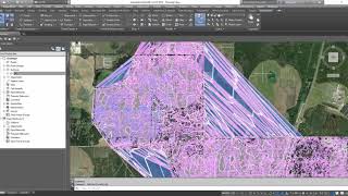
- Source lidar, contours and DEM elevation data using Equator: maps.equatorstudios.com/?entr...
***The Equator user interface has been updated.****
Tutorial on new Equator user interface: • Site Builder Overview
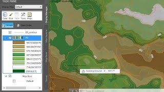
In this video, we show you how to create smooth contours in Civil 3D from lidar and lidar-derived Digital Elevation Models (DEMs). All data was sourced from the USGS 3DEP lidar data set, accessed using Equator.
Check out this link to try now: maps.equatorstudios.com/?entr...
This video will answer the following questions:
1. How to create smooth contours in Civil 3D from lidar
2. How to create a surface from a DEM in Civil 3D
3. How to combine surfaces in Civil 3D
If you liked this video, check out these other ones:
- Equator 101: • Equator 101: How to fi...
- Access USGS lidar data online: • Where to find LiDAR da...
- Create a surface in Civil 3D from a lidar point cloud: • How do I create a surf...
- Create a surface in Civil 3D from GIS data: • How do I create a surf...


We are constantly making improvements to our user interface. If the UI in this video doesn't match the current UI of the Equator platform, watch our latest video on extracting data from Equator's newest interface: ruclips.net/video/Ogy6F-Fczac/видео.html
this video is brillant!
When I do exactly what you did, my DEM surface look just as bad as your point cloud surface. What would cause that?
Do you know the resolution of your DEM? If you are creating the DEM from LiDAR, the resolution may be too high. You can try lowering the resolution - try 1 or 2m to start. Then, you can add more detail in the areas you need. If you are not working with LiDAR, it is possible the DEM is too low resolution and is just missing detail resulting in jagged contours.
Would you get the same result using the Smooth Surface edit, and leave out the areas of extra detail?
Great question! You may loose some of the detail with the Smooth Surface edit. We provide one method in this video. Our suggestion is to choose your method based on the accuracy you need.
What do the triangles look like? How big is the file.
The size of your file will depend on many factors, including the size of your site and the resolution selected for the export.
how do you export the data from this service?
In the layers menu you will find a download button next to the toggle visibility button.