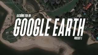
Finding Secret Fishing Spots With Google Earth! (Actual Favorite Waypoints Shown!)

HTML-код
- Опубликовано: 25 авг 2020
- There are so many Google Earth Tricks fishermen don't know how to use! With our cross country move we've been spending a ton of time on the computer preparing to explore new lakes. We've found a bunch of new spots using this method and today we're showing you how to do the same. Come along to some of our favorite fisheries and see our best spots as you learn the methods! (If you're a California angler, get ready to write down some coordinates!)
Every angler knows you can jump on google maps and get a good idea of what a lake looks like before you arrive. But few anglers know how to remove distortion from the map, jump between different water levels and times of year, drop waypoints, and export all of it to the electronics on your boat. Its amazing how far technology has come and if you're not progressing, you're falling behind.
Google Earth is just one of the tools you have available as an angler today. Modern electronics have seen huge advancements as have the mapping cards that we use with those units. Google Earth is a free program that any angler with a computer can use. We combine that program with a few different electronics to maximize our time on the water. Below you'll find links to a few of our favorite items from different brands to help maximize your time on the water.
Our Electronics and Mapping...
-Humminbird Solix 15 CHIRP G2 Depth Finder: bit.ly/2Hazsej
-Lakemaster Plus Digital Charts: bit.ly/2Dk5Erc
Budget Alternatives...
Humminbird- Helix 7 CHIRP G3 Sonar: bit.ly/2SoFl8a
Lowrance- Elite 7 Ti2 Fishfinder: bit.ly/3aY4m4S
Alternative Mapping...
Navionics Hot Maps Platinum: bit.ly/2ZitTiR
NEW Tactical Bassin Apparel...
TacticalBassin Reaper Hoodie: bit.ly/2TwBWs7
TacticalBassin Shadow Hoodie: bit.ly/2FVD9Rs
TacticalBassin Sun Shirt: bit.ly/2TvFMBD
TacticalBassin Hooded Sun Shirt: bit.ly/38cVi9G
_________________________________________________________________
What we wear...
Sun Mask: bit.ly/2JcA8xi
Sun Shirt w/ Hood: bit.ly/38cVi9G
Light Fishing Pants: bit.ly/2foDx10
_________________________________________________________________
Equipment We Recommend...
Minn Kota Ultrex Trolling Motor: bit.ly/2vFQypW
Humminbird Solix 15 Electronics: bit.ly/2Hazsej
Minn Kota Talons: bit.ly/2F0QBSP
Hot Foot Throttle Control: bit.ly/2ob4kgO
Loc-R-Bar Boat Security: bit.ly/2CMF1NP
Favorite Storage Box: bit.ly/2fvjcFB
Favorite Pliers: bit.ly/2tfxFvw
Favorite Split Ring Pliers: bit.ly/2fT4Qw0
Favorite Wire Cutters: bit.ly/2soB34k
Favorite life jacket: bit.ly/2odXXIP
Favorite sunglasses: bit.ly/2glE3eN
Hero8 Camera: bit.ly/37hVTX4
ElectroSamson Scale: bit.ly/2f7QgQ9
Frabill Net: bit.ly/2FNdnQr
Lure Retriever: bit.ly/2TLTJc6
________________________________________________________________
If you plan to do any shopping, using our links before doing your shopping at Tackle Warehouse is the single greatest way to support us! You won't be able to even see a difference but they'll know you're one of us!
#bassfishing #googleearth #fishing  Спорт
Спорт


Pro tip, you can turn off tilting while zooming. Go to tools->options->navigation tab, then bottom right choose 'do not automatically tilt while zooming'
Thanks Johnny!
instablaster...
I would love to see a video of you going over these waypoints with your electronics and showing what they look like for example, the rock wall would be a good one. Great video can't wait for more!
Definitely, I needed to know this thanks Tim🎣🎣
If you're a bank fisherman DEFINITELY still do this! I've picked up doing this earlier this year and it has paid off 10 fold!!! Specially if you have only a few spots available to access this is key to better your fishing!
Great Video Tim. Thank You for the Information. This would be great to do in the Winter Months, when the Snow is falling. You & Matt come up with some Wonderful Ideas for Fellow Anglers.
Great video, I’ve been using Google Earth for years! Tim you just added a new dimension to it! Thank you! I’m just about to get a new boat which I’ve purchased with Hummingbird solix units for the bow and center console, with lake master! This will save time and gas! I’ve become more of a fish hunter(bass), I think this is one of the best videos you two have ever done! I subscribed about two years ago, one of the best moves I’ve ever done! Wow! However I favor smallies and finesse fishing, this will help greatly! Yahoo!
Please erase this video so no one else, will see! LOL haha!
Can't wait for the next installment
One of your best videos in a long time. Very intuitive. TY
Glad it was helpful!
@@tacticalbassin You shou have an in-depth class from logon to downloading to your graphs and everything in between...I would pay to see that...Hell you can get 100's subscribers to pay... Thanks
Can't wait for the second part to this!!
Great video. Im about to fish Clear Lake for the first time in a week and will definitely be using these tips. Thank you so much.
This as been part of my way to prepare myself for a little while now. It saved me tons of time and made me a good bit of money. Made me get an edge on a new lake vs the locals. The advanced version to transfer all of this on the units is gonna be interesting for a lot of folks. I now have a system for this and it pays off big time moving from lake to lake!
It is very useful! Yes the second part will be a little bit tricky for some but its not too hard.
Love it! Can’t wait for the next one in the series!
I have seen many good videos utilizing Google Earth. This videos the best. Looking back at historical low water levels reveals so many more possibilities to cast when the water levels are higher. Thank you so much.
Awesome tip and very clear explanation of how to use. Great job Tim! Welcome to Tennessee!! Can't wait to see you guys up here on Cherokee and Douglas some day.
Thanks so much Steve!
Great video! Checking out the terrain before going is always great! But sometimes you dont know till you get there! haha
This video is INCREDIBLY useful. I would recommend a series of these that help us to understand how to tie (end to end) this all together. If you did this on your new lake in Tennessee it would be a fantastic value for you and us. Bravo! This is INCREDIBLY helpful!
Thank you Michael! Its on our schedule of videos to do.
This is great Tim. I already use google earth, but I’m just scratching the surface on it’s functionality. The ruler in tools is excellent for plotting a kayak route! I’m looking forward to the next video!
Great stuff. Dropping the pro tips. The electronic technology is very interesting.
You just took my game to the next level.
Love the tips Tim! This will help out big with my kayak, my main lake is drained due to dam construction this will be awesome and very useful for other lake's for me, great video! Hope Chic produces some giants for you guys! Stay safe and healthy out there guy's and tight lines!
If your lake is drained maybe the empty lake will make Google Maps
Awesome tip!!! Thanks
Good info, gonna play around with this. Thanks guys.
Our pleasure!
Great video, I am looking forward to you going deeper into this subject.
Another great video keep up the great work guys. Google maps is usually how I set up my days out on the kayak.
It saves us so much time when traveling around the country and fishing new water.
@@tacticalbassin I saw in your moving video that you're going to hit more of the east coast now that you're closer. It would be awesome if you guys came to the Delmarva Peninsula, I live in Maryland and fish MD and Delaware and have never seen anybody do videos on this area. Except for guys that live here just doing little videos of themselves. I specifically say the peninsula because if you tell big time guys MD they're probably going to go to the Upper Chesapeake and that's nothing like the peninsula, even the rest of MD at least has reservoirs. MD has no natural lakes that exist present day and all of the man made ones on the peninsula that includes MD DE and Virginia (the last being a small portion that I don't really fish) are nothing like any lakes I've seen people fish in videos. They're much more shallow and have different vegetation than what I see in videos of other areas and are pretty much non existent of rock bottoms. It would be great to see how a pro picks them apart.
Well done tim. That was a nice class.
Bring on part 2 for this, please! I’ve been wearing my eyes out looking at google earth for too long. 😂 need to put these waypoints in my graph!
Putting Lake Oroville on the map! Hope Tennessee continues to treat you and the fam well. Definitely one of my bucket list states to visit!
Excellent. Thanks Tim
Love it thanks! You guys are my fav fishing gurus. Question: What program do u use for video editing.
Can't wait to see the file transfer video. Google earth is amazing. Thanks for the great stuff
Love this video. I can even use it for smaller lakes here in PGH. Enjoyed the explanation. Will try to use with my kayak. Don't see why it wouldn't work.
Hey Tim, great video, as always. When will you be doing the video on how to export the waypoints and uploading them into your graphs??? Thanks.
Good stuff Tim! 💯
Appreciate it!
Been doing this for about 5 months now but transferring entire files. That’s no joke Tim. I spent DAYS way pointing Shasta and it paid off huge on those spotted bass.
I would name them all “snags” “big snags” “ really big snags”
:) haha
Right on Tim
This is definitely one of my favorite TB's video. Thanks a bunch.
FYI for all:
Keep the name short. When you load them up in your unit, it will cut off part of the name. For example, long tapering point will be long tape
Totally agree! I actually use Humminbird PC and you can go in and edit/delete the names if you choose.
Great video thanks for the information
Welcome to TN guys, yall should come up to Old Hickory and do a video
Thank you that is very helpful
Been using Google earth for years, good info. for everyone which is how you guys shine. Does anyone in CA make maps of the lakes when their at their lowest? There's a way to download google earth so you can use it as a background, then when the lakes full, all those rock piles, stumps, rock fences show up on the screen when your fishing. Huge advantage!
Just like Edwin Evers latest videos! Very helpful thanks
Thats funny! It is a very useful tool and really helps us dial in new fisheries.
Fish the Moment YT channel did this over 2 years ago.
I love using Google Earth ( or even Google maps in satellite mode) when looking for new places to fish. I recently found promising areas that I should be able to catch fish almost year round.
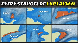
To add to this, I’m strictly a shore angler so this really helps find rock piles, sunken trees and creek channels that swing close to shore.
God is good
Yes he is
Another Gem
Yes!! Still giving love to us CA! Was headed out to Oroville Lake too!!
Thanks for giving Lake Oroville some love! Maybe one day we’ll cross paths 🎣
Awesome never knew how to use google earth thanks
This might be one of the best things I have seen for bank fishing. All the structure and timber along the banks is easier to see from the air and now I got targets to cast to I didn't even know about! I know what I'm doing on this rainy wet nasty day inside
God is good
This is an awesome tool, up north we have a problem to deal with when using....ice!
Camera quality is 🔥
Wow, whis I had known this earlier in the year but thanks anyway i can use it now
I’ve been doing this for years. I’ve found not only spots on body’s of water but I’ve found little hidden ponds and have had great results. Rolled up to a pond we found on google maps and caught 63 bad over 3 pounds
Love it 😀 please tell me y'all are gonna start guiding on chickamauga??
Eventually when we get all moved in.
Tim we need the info on how to transfer these points to our electronics...Lowrance, etc. Would come in handy for next weekend 👍
Thank you
Used this to attack Trinity! Great way to find fishy areas and locate specific regions that you can duplicate around the lake without prior knowledge or experience!
I've been using Google maps for couple of years now to find ways to get to spots on the shore. You can find trails that get you back to spots you can't even get to in a boat
Another great thing to do for man made reservoirs is to look up maps from before it was made. Public libraries in the area will usually have them archived but a lot are available online.
More on this subject please Tim.
I live in Lakeport, I didn't know for a long time that Clearlake is a good place for fishing!
Is Tim still a Firefighter? Or am I confusing the situation with the move to TN...regardless...this is a great channel. Keep up the great videos Gents!
From what I know, he was a game warden in Cali. Probably will be in Tennessee
@@kongvang4132 Ah Gotcha...Game Warden...I knew he was a public servant/Gov't agency employee of some kind...thanks...Great Content!
Great tip. I've seen this in the past over at Fish the Moment (That kid also has a great channel! Do you guys know each other? ) Too bad this doesn't work in Mexico XD
Groovey little chicken. Thanks
Definitely do a video on how to upload them to hummingbirds
I’ve used it a lot to find ponds and rivers/creeks by my house
I feel bad for the people who found these spots on there own, but this is a good video I love google earth
Hey guys buzz bait season is close and I’m having trouble of making a buzz bait run straight do you have a video on it or do you know where I can find information on how to mat or tim
TackleJunky81 just recently did a video on tuning a buzz bait.
Maybe a dumb question, but when you were looking at Lake Orville, is the tan structure under water? Or is that shoreline? Or is it stuff that's under water at times and above at times? Thanks for the awesome videos.
As you scroll through the dated pictures you will see the water rise and drop. The tan is the shoreline shown at different water levels.
@@tacticalbassin Thank you! I want to come down to Tennessee and have you guide a trip for me and my Dad! Are you doing any this fall? We normally go to Canada and can't due to COVID-19. Let me know. Thanks again
You can reformat the long and lat on Google Earth Pro so it goes with Lowrance’s format. Yeah, cats out of the bag, Project E just did a UT video showing this same content.
I just searched this topic on YT. There are several videos on the topic. Some as far back as 3 years ago. Who knew 🤷🏼♂️
Must be everyone has decided to share this now.. It's been on 3 different channels in the past week
TB makes 140+ videos per year. Often times the same ones just updated year after year. This video was awesome. I don't care at all if they saw the concept first on a different channel. TB probably did it better.
@@ericm425 no I enjoy this channel and learn a lot from it. Watched it for years. Still remember when they were small enough to reply to some of the comments. But this isn't a duplicate.. And they do a good job.. One of the others I enjoyed more on this topic though.
exactly
Oh thats funny! Everyone will be Google Earth Pros now.
@@tacticalbassin unfortunately on SML there are no pictures between like 94 and 2002
Hey Tim, when can we expect more of these videos?
And is it weird that my Google earth layout is completely different? Is this an app download or is this online on the Google earth website?
Love u
If I use Google Earth on my computer under the same account as I use Google Earth on my phone will the waypoints carry over? I strictly bank fish at this time.
Are you guys planning on doing the next video of uploading to units anytime soon?
When Re you guys gana co.e to Texas? Show some love to austin Texas.
You must show us how to transfer to fish finders!
Can you transfer to garmin too?
What battery Tim would you recommend for running a helix 12 g3n a helix 10 g3n and a helix 9 g2n all at the same time I want as much run time as possible I currently have a group 24 battery with a res min 178 but it’s on its way out and I can’t go lithium thanks Tim you guys are the best
We use the Odyssey 31M-PC2150 marine battery. Its heavy but the best we've found besides lithium.
TacticalBassin you guys are the best thanks for taking the time to answer hope you had a good move and can’t wait to see you in New Hampshire God bless
You need to show how to change the default on google earth to the correct gps format for the depth finders. This can be done on the google earth settings.
Now that you're here in TN, when will you start transitioning to fall fishing?
Very soon 👍
I’m planning on getting my second baitcaster but I can’t decide whether to get the curado k or to save up for a bit longer and get the bantam. Do you think the extra $150 is worth it?
Both are great! The Bantam is so smooth but it depends on if you want a higher end combo or not? With the extra money you could get a higher end rod...
I’m looking for a high mid-end combo so the budget $500 and I’ve already got a rod picked out. Mostly going to be throwing spinnerbaits and chatterbaits or just most other reaction baits
Linus Chen for reaction baits I’d recommend more money in the reel than the rod. The ultra ultra sensitivity won’t help you as much in reaction situations than say finesse or bottom contact.
what version of google earth are you using. I have been unable to find your version with the user bar on the left side
It’s got to be google earth pro and download the desktop version. It’s totally free and definitely worth it 👍
What search engine are you using I can’t seem to find the button to go back in time
As a bank fisherman, am i able to make waypoints and then save them somehow to google earth or google maps on my Samsung smartphone?
Which google earth are you using? Mine did not have the photo option to see past photos.
How do you get the menu column on the left of the screen to come up?
You should take the cat in the back fishing!
LOL! My kids cats are always in the way
TacticalBassin haha! You should get the cat a little jersey and a hat
10 boats on that point tomorrow. LOL
How do you able to see what it looks like overtime? i can’t figure that out
@TacticalBassin I saw in your moving video that you're going to hit more of the east coast now that you're closer. It would be awesome if you guys came to the Delmarva Peninsula, I live in Maryland and fish MD and Delaware and have never seen anybody do videos on this area. Except for guys that live here just doing little videos of themselves. I specifically say the peninsula because if you tell big time guys MD they're probably going to go to the Upper Chesapeake and that's nothing like the peninsula, even the rest of MD at least has reservoirs. MD has no natural lakes that exist present day and all of the man made ones on the peninsula that includes MD DE and Virginia (the last being a small portion that I don't really fish) are nothing like any lakes I've seen people fish in videos. They're much more shallow and have different vegetation than what I see in videos of other areas and are pretty much non existent of rock bottoms. It would be great to see how a pro picks them apart.
Also there are two trophy ponds on the peninsula, "referred to as The Eastern Shore" they are both in Salisbury MD and are called Johnson Pond and Leonard Pond (both actually lakes)
I used to use Google earth a lot. Haven't used it in quite a few years. Did not know you could go back and look at old photos. Is that something new in the last few years?
I believe that's only available on Google Earth Pro.
Thanks. I'll have to check that out tonight.
Edwin Evers had a good video on this too
Sounds like a couple channels did recently. Everybody is going to be Google Earth Pros in no time 👍
It really is good stuff fishing some of these waters especially in florida where it’s just chocolate milk or tannic it’s hard to know what you are throwing to. Great stuff
Is this google earth pro? I can’t see old images on my google earth. Only recent aerial footage
Yes it’s got to be the Pro version. It’s a free download 👍
Can you do a follow up video how to coordinate the way points in google earth over to the hummingbird units?
Does anyone know how to set it up? I can’t figure out how to find a lake and go back in time
Not sure what I'm doing wrong when I go on Google earth I don't see that year button on the bottom left to click.
Please show us steps to upload google map waypoints to Humminbird Helix
You need some artwork on your wall
Lol yes we do. We are still moving in so we probably wont get to decorating for a little while
Please show steps to input google map waypoints into Humminbird Helix
Forgot to mention you have to use Google Earth Pro to show past images and save it on an SD
We planned on doing a second video for that. Its a little more in depth depending on what graphs you use.
just came over from Evers channel....he breaks down the spots a bit more thorough
Just an FYI. It only works with Google Earth PRO. Not the standard Earth