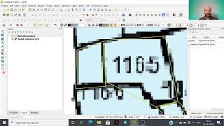
POLYGON DIGITIZATION USING SNAPPING OPTION IN QGIS

HTML-код
- Опубликовано: 21 авг 2020
- Dear Viewers
In this video, I have demonstrated the Polygon Digitization using snapping tool in QGIS. It's really easy and helpful to prepare the village boundary or
large scale mapping of farm lands. If you like this video then please subscribe my channel and share the video.


This was very clearly explained and useful, thank you!
So simple to do and very helpful, thanks.
That was really explained very nicely. Thanks for this video. 🙏
I've been looking for this Thank you Sir, that was helpful
Thanks a lot, Professor. All the best.
Thank You Sir
Thank you very much!!!
Thank you for this.
It is not to avoid overlaping but to save time as well
Thank you
You just provided me with the answer i was looking for all over the place on how to draw adjoining polygons without overlap. THANK. YOU. I do have a question though. How can you achieve the same result using a "free hand" editing tool so your polygons have smooth edges and not blocky ones... thanks again! any help is appreciated
Very well explained for begginers
Thanks Ma'am..
i realize it is kinda randomly asking but does anyone know a good place to stream newly released tv shows online?
@Ayaan Alvin I use Flixzone. Just google for it =)
After insert shape file.
solid fill / colour hatching not coming,
What to do.?
Right click on the layer name..go to properties...symbology..
@@geospatialworld926 IN SYMBOLOGY ONLY LINE -SIMPLE LINE IS COMING, NOT FILL BY DEFAULT. I NEED FILL SYMBOLOGY BY DEFAULT AFTER INSERT SHAPE FILE.
How to open that tools..? snapping and overlay,..
Please watch video consciously...
@@geospatialworld926 thanks, I've found it.
From where can i download block map including all villages?
You can get it from your state remote sensing centre.. I got it from MRSAC..
Where do you from???
@@geospatialworld926 Haryana
So you can get it from HRSAC, by the way I have been there in Rohtak, M. D. University, you may know Dr. Mehtabsing Rana....
Sir, avoid overlapping option is not available in Qgis 2.18.So how to resolve it
Please use 3.14 version of Q GIS...
Ok
Hello sir please reply
Thank you