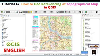
Georeferencing a map using QGIS

HTML-код
- Опубликовано: 30 июл 2020
- Hi Viewers,
Here you will come to know the process of georeferencing a toposheet or a map using QGIS.
Steps to follow:
1. Open QGIS and see that georeferencer plugin is added. if not, go to plugins and select.
2. Go to Raster - Georeferencer - Georeferencer.
3. Add unreferenced map to window.
4. Go to settings - Assign projection information and output path and file.
5. Go to Add points - Zoom to level and add point and assign long / lat for the all added points.
6. Save ground control points.
7. Run - start georeferencer.
8. Once georeferencer is successfully completed, close georeferencer and add the referenced map to QGIS window by add raster layer. It may used for further wotk.


Done great job sir. Very easy to understand the process of georeferencing in QGIS
Keep watching
Thank you for the video. Easy to understand
Very Good Sir. Keep Adding more tutorials using QGIS Sir
Ok. Thanks
i guess it's pretty randomly asking but does anyone know of a good website to stream new series online ?
Thank you! Been using MapWarper before, but you it looses you a lot of quality there, but in QGIS it's great.
Greetings from Sweden!
You're welcome! Keep follow
Nice info sir
Thanks
Nice tutorials
Thanks for comment, keep follow for updates.
Nice video
Thanks
Sir my georeferencing is being successful but before clicking georeference there is showing errors in the points what does that mean??
Restart the software
Which version is this
Etha epdi document ready pannanum
Sir in 2.6 version after doing the georeferencing the map was blur... How to correct it?? Plz
Dear Moumita, Your target resolution may be low. try to increase it in the transformation settings. Otherwise don't opt that. leave as it is. It may be fine. Try it. otherwise i will look into it. Thank you for the comment.
@@msrgeospatialsolutions sir please help
what should be the file format of topo sheet for performing Geo referencing?
/
You can add toposheets or maps which are in image formats like jpg, jpeg, tiff, geotiff or .img etc into QGIS. Thank you for comment. Please follow the channel for updates.
@@msrgeospatialsolutions Sir i perform the Merge operation for making the Mosaic from Geo referenced tiles in QGIS. But after it shown error in .vrt file and show a Black patch in QGIS window. Why so?
@@mohitmittal2627 Let me check the problem.
What is the purpose of Filter?
I dont know what to put there
Thank you for comment. Filter option is only to search your required projection information to assign. As we need to assign any of the projection systems, you can type the projection information like wgs or utm or any other specific.
Sir, how to add GCP TABLE
Thank you for comment.
To add GCP table, go to add gcp table from georeferencer tool bar and add file from respective path
now georefrencer is under Layer tab.
Thank you for info. Keep follow for updates
thanks for that , theres another plugin now that is called freehand raster georefencer and does now bring up the separate panel window shown in the video