Add GPS Data Overlays to Sony Video with VIRB Edit software

HTML-код
- Опубликовано: 8 сен 2024
- How to import video with GPS Data made by Sony action camera to VIRB Edit for more customization using GPSBabel. How to overlay data (latitude and longitude) from Sony Cam with Garmin Virb Edit.
Sony software app Play Memories Home has very poor Multi View settings. VIRB Edit has a huge variety of settings to work with video and GPS data, but it's tricky to transfer video and GPS data from Sony action camera to VIRB Edit. In this video I will show you how to do it.
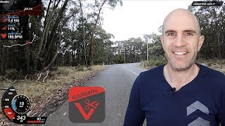
You will be able to show on your video GPS coordinates, Speed, Position and a lot more data with ability to customize them as you wish.
GPSBabel needs to convert NMEA file to GPX file.
It works with Sony HDR-AS100V, HDR-AS200V, HDR-AS300, FDR-X3000
Data that you will need to add to your GPX file:
drive.google.c...
GPSBabel converter:
www.gpsbabel.o...
VIRB Edit for Windows
www8.garmin.co...


STILL WORKS GUYS! I'm on a Mac first, and Failed to read File, and when I'm on Windows, it Works just like his instruction! GO TRY IT! I'm using FDR X3000 too.
Just tested and works fine with my FDR-X3000 :-)
Hi,
I followed your instructions step by step and everything works with my HDR-AS200. Great job, thanks for it!
My only concern with the Sony GPS is the amount of data collected, the rate is low. I think this is the reason why the speed dash or cluster looks like a delay and don't change smoothly. This is the same behavior using the Sony Play Memories app.
Also, in my VIRB version, there are only a few templates, and not like your templates that are a lot.
I will continue playing with this option because definitely is the best that I have seen.
Best Regards,
Thank you. Very helpful!
Wow, really complicated, but it will be worth it for me. Thanks, I'll have to be sure to save this video.
Спасибо большое! Давно искал!
спасибо за полезную информацию!
Muito obrigado!!! Você me salvou! =D
Great tutorial!
No works :/ any idea? (failed to read file)
I am using a Sony Handycam CX260 with GPS. Can I bring that footage in and use the overlays?
Большое спасибо за видео. Очень полезно.
Сами приборы работают.
А вот с мультикам'ом никак не получается.
Есть видео с 2х камер, которые записаны синхронно с одного пульта. Virb Edit их определяет как записанные одновременно и предлагает включить режим "мультикам". Но при перетаскивании клипов на панель монтажа режим двух камер не включается. Не могу понять, что именно не так. Пробовал даже 2 пары одинаковых видео и gpx файлов скармливать - та же история.
I just tried this work around and it didn't work, but when I pasted the converted file into note pad the code didn't look like what you had in the video. I really can't believe this is the easiest way to change the log files from the Sony so Virb can read them. Has anyone found another solution?
You are a legend my friend! I've been looking for this solution for months. The only question I have is: I have a Sony FDR-X3000, when I do the steps you teach on the video I can't get the altitude. Do you know why? Thanks.
Thank you.
I'm afraid that FDR-X3000 doesn't have capability to record an altitude.
community.sony.cz/t5/action-cam/fdr-x300-gps-altitude/td-p/2246817
From this thread:
This is a part of LOG file from my HDR-AS100V:
@Sonygps/ver5.0/wgs-84/20180324210303.000/
@Sonygpsoption/0/20180324210337.000/20180324194700.554/
$GPGGA,194700.554,4912.5114,N,12307.3532,W,1,0,,,M,,M,,*60
$GPRMC,194700.554,A,4912.5114,N,12307.3532,W,1.68,,240318,,,A*61
$GPGGA,194701.554,4912.5106,N,12307.3544,W,1,0,,,M,,M,,*63
$GPRMC,194701.554,A,4912.5106,N,12307.3544,W,1.81,,240318,,,A*65
$GPGGA,194703.000,4912.5102,N,12307.3555,W,1,0,,,M,,M,,*61
$GPRMC,194703.000,A,4912.5102,N,12307.3555,W,1.77,,240318,,,A*6E
www.gpsinformation.org/dale/nmea.htm
GGA - essential fix data which provide 3D location and accuracy data.
$GPGGA,123519,4807.038,N,01131.000,E,1,08,0.9,545.4,M,46.9,M,,*47
Where:
GGA Global Positioning System Fix Data
123519 Fix taken at 12:35:19 UTC
4807.038,N Latitude 48 deg 07.038' N
01131.000,E Longitude 11 deg 31.000' E
1 Fix quality: 0 = invalid
1 = GPS fix (SPS)
2 = DGPS fix
3 = PPS fix
4 = Real Time Kinematic
5 = Float RTK
6 = estimated (dead reckoning) (2.3 feature)
7 = Manual input mode
8 = Simulation mode
08 Number of satellites being tracked
0.9 Horizontal dilution of position
545.4,M Altitude, Meters, above mean sea level
46.9,M Height of geoid (mean sea level) above WGS84
ellipsoid
(empty field) time in seconds since last DGPS update
(empty field) DGPS station ID number
*47 the checksum data, always begins with *
So, the number before 'M' is an altitude. In my LOG there is nothing
You can use the following site to add in the elevation metric to your logs: www.gpsvisualizer.com/elevation I guess this thing only puts in the elevation of the point on the ground of that lat long. If you are looking for elevation of jumps or aviation type stuff this obvs won't help
sadly that gps data seems easily fooled. I did a quick video walking and it showed me WALKING at some 7MPH - while I was standing still, opening a door. also make sure you remove "TheTrick4Fun" from creator, so he cannot claim your videos.
Я так и не понял - в verb можно сделать отрисовку карты в видео, а не просто кривую маршрута?
сделай скрин карты и наложи в прозрачности. нет пока ни одной софтины которая смогла бы это все проиграть на карте в реалтайме
it works in windows but not Mac
It used to work in Windows. Sony seem to have stopped supporting it
I watched most of this but then i ended up stoping when you had to fiddle about with changing the gpx files and use other programs for me its more hassle than its worth adding this in having to do it for every file yeah naaaa
I just tried it & it didn't work. Virb Edit shows nothing when opening. ??
Faith & Action
Did you change your GPX file by using my text from GPX.txt as I showed?
If you do exactly what I did, it will work. If you miss one step it won't work.
Yeah I did exactly what you showed. It's not that complicated. I hope to figure it out so I can use my sony with the overlays. Thanks for your help.
It worked! When I saved it the first time from notepad it saved as a text doc. Thanks a bunch! I make Christian snowboard videos in the backcountry of rural Alaska & I'll be using the Sony mini for a helmet cam with a Garmin Virb Ultra 30 in a follow drone, so it'll be nice to use the G-Metrix's. faithandaction.net
2 of the important G-Metrix it shows are there don't actually function with guages: grade & elevation. Any idea why?
As I know action cameras Sony doesn't support altitude (elevation). I might be wrong.
community.sony.cz/t5/action-cam/fdr-x300-gps-altitude/td-p/2246817
OVERLAY NO LONGER WORKS- SONY NO LONGER SUPPORTS GPS OR STREAMING-