ctrl+scroll up will give you a reasonably smooth 360 so your fly around will be much more easy. I literally lost my mind trying to fly around accurately
Thank you for this process, what a time saver! Also found that I could just have Reality Capture pull the frames from the video without having to resort to using After Effects or any other program! Thanks again!!
Imagine making GTA 10 with a perfect 3d-scan of the entire Earth! Perhaps it could be 3d-scanned over time by crowdsourcing from gamers with smartphones that have lidar or consumer drones? The world would probably have to be streamed like MS Flight simulator 2020 does though...
They already have laser scanned race tracks and street circuits on older race sim games so I def see that as a possibility. Only real bottleneck might be storage for all that data.
Isn't there a way to directly pull photogrammetry already out of Google earth maps? Thought it was pretty open source. If not this is a crazy good work around.
Could I use a steady cam to take video of my head and use the software there to make a 3d stl of my head? If so you just solved a 10 year problem I have had.
Thanks it really works. But a bit difficult to turn around map for recording video. I found the easy way for it!!! :))) Up right corner map has big circle with a letter N. Just click on N and turn around!!!! That’s it!!! Thanks a lot
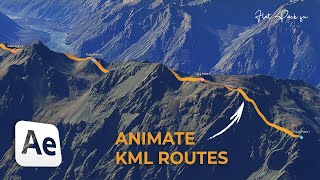
@@CapturingReality hi, thank you, it would be really good to export it to kmz or kml. i exported the ortho projection as a jpg file and manually added it and aligned to Google Earth, i also got a .jpw and .rcortho files, are those the files to use on google earth to reference it the ortho picture?
As a next step, we'll show you how to scan your printed terrain, photocopy those images several times over, and turn them into Google Earth, further degrading the existing data.
@ideaform3d Oh I'm just teasing - it'a a neat tutorial but also along the lines of using photogrammetry to capture from game when there are other ways of getting the actual model data verbatim.
I've done the same tutorial about 2 months ago. By the Google Earth license, you are not allowed to make a profit this way. Give me 1 week. That map is outdated. You can now download 0.25m to 1.00m lidar data. Google Earth is made of 15m DEM.
Hi there! I'm wondering if you'd be interested in helping me do something to help support local food production in my community. So my partner and I have some 7 acres of land that we would like to plan out for restorative agriculture using the principles of permaculture, for the benefit of producing food for generations to come. I have been dreaming about creating a 3D model of the land, either digitally or like a model that would sit on the kitchen table to help us visually plan out the farm, because elevation, water drainage, how light hits the space, ALL of that makes a difference when planning land in a way that allows the characteristics of and microclimates within a landscape to do some of the work for you. It's a very ancient form of farming that is much more methodical and difficult to start, but once it's up and running, is supposed to be far easier to maintain than modern or shall we say "traditional" monocrop farming methods (which aren't all that traditional, if you catch my drift). My partner is a constructor worker-turned-hobby farmer, and I'm a life science grad who actually had a near death experience where I realized all I want to do is return to the land and farm and have kids. Lol! Which is a far cry from what I was doing before almost dying, which was a medical student. What do you think? Would you be able to help me figure this out? Is there anyone out there interested in helping me create this? I wouod love to hear your feedback! ❤ Im not skilled with 3D printing nor am I great with computers, but with you video tutorial I'll do my best to figure it out on my own. I live near the Dundas Valley Conservation in Ontario, Canada. It would be an interesting project to collaborate on because the natural/organic farming we intend to do is in Canada's Greenbelt, also inside a Conservation area, and is also beside a deep artesian spring called Sulphur Springs! 🇨🇦 Much love from the North! 🦫
The big question for me is how to put this into business and make cash out of it? I also put this comment on Instagram if you do not find it a dumb question!


![Noob To Max With DRAGON REWORK In Blox Fruits [FULL MOVIE]](http://i.ytimg.com/vi/LnBMOinoOvA/mqdefault.jpg)
![Felix "Unfair" | [Stray Kids : SKZ-PLAYER]](http://i.ytimg.com/vi/Oswujxm2Ag0/mqdefault.jpg)


ctrl+scroll up will give you a reasonably smooth 360 so your fly around will be much more easy. I literally lost my mind trying to fly around accurately
Thank you so much lmao I thought I was the only one losing it
Thank you for this process, what a time saver! Also found that I could just have Reality Capture pull the frames from the video without having to resort to using After Effects or any other program! Thanks again!!
Imagine making GTA 10 with a perfect 3d-scan of the entire Earth! Perhaps it could be 3d-scanned over time by crowdsourcing from gamers with smartphones that have lidar or consumer drones? The world would probably have to be streamed like MS Flight simulator 2020 does though...
They already have laser scanned race tracks and street circuits on older race sim games so I def see that as a possibility. Only real bottleneck might be storage for all that data.
So is there no way to output the .stl from RealityCapture without paying per file?
Isn't there a way to directly pull photogrammetry already out of Google earth maps? Thought it was pretty open source.
If not this is a crazy good work around.
there is: renderdoc
Could I use a steady cam to take video of my head and use the software there to make a 3d stl of my head? If so you just solved a 10 year problem I have had.
Well yes, it can be done.
@@moboahenedid it with polycam instead
Next someone needs to figure out a way to directly export a 3D scene based on a geofence radius or square
Is this going to work for anythign other than a naked hill? Can you do this with buildings?
Hi, it should work also for building. Sure, it won't be so nice as from images, but if you will create good overlapping pictures, then it will work.
There has to be a way to extract the obj file from Google Earth.
Thanks it really works. But a bit difficult to turn around map for recording video. I found the easy way for it!!! :))) Up right corner map has big circle with a letter N. Just click on N and turn around!!!! That’s it!!! Thanks a lot
hi, very good video, thank you... can i export drone and ground photogrammetry 3D models to Google Earth (.kmz/kml)?
Hi Daniel, not the models, only the orthos.
@@CapturingReality hi, thank you, it would be really good to export it to kmz or kml. i exported the ortho projection as a jpg file and manually added it and aligned to Google Earth, i also got a .jpw and .rcortho files, are those the files to use on google earth to reference it the ortho picture?
how did you open mkv format in after affects??
MP4 file was imported, not MKV.
Great video! I did the video editing with DaVinci Resolve and it worked just fine!
Wound the process be similar if you wanted to import a 3D model if a real life statute? Then import into cities skylines game?
Yes, it should be similar.
Very clever! Will have to give this a try.
Superb work!
There is an option at OBS, which lets you achieve high quality recording without the optimizations for broadcasting. I'll try that.
what if the 3d data is not available. Can you generate photogramerty from flat google earth images. How do google do it?
If you have more images of the same object from different angles, then it is possible to create a 3D model of that object.
awesome video! one thing to note however, you can choose to not capture the mouse in OBS. otherwise, AWESOME!
found it!
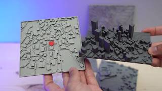
Really a wonderful job !!! Would it be possible to do something similar about a city or a portion of it?
Theoretically it should be possible. It depends on the model of the city.
@@CapturingRealityI would like to make a portion of my city, Genoa, Italy. I hope one day you will make a video about it!
How to color it ?
From the used images, you can use Colorize or Texture tool when you have created model.
@@CapturingReality I mean how to color print 3d model is there any ways to do it ?
Great video! any tips on adding colors?
What a crazy over engineer solution!
I was expecting a simple program to steal the elevation map from Google
Hello, how do I export the mesh from the apps for free? I need to pay for it but it will be great if you can show me how. Thank you
buy a cli license
Great Vid! Thanks!
thanks, can we do it with humans? :)
Fantastico !
I looooove his voice
As a next step, we'll show you how to scan your printed terrain, photocopy those images several times over, and turn them into Google Earth, further degrading the existing data.
@ideaform3d Oh I'm just teasing - it'a a neat tutorial but also along the lines of using photogrammetry to capture from game when there are other ways of getting the actual model data verbatim.
Smallpoly is there another way of getting a mesh/stl/obj of the terrain from google earth ? Need something like this for a study model
Three thousand years from now one finds that model and thinks it's sculpted by erosion.
Pls qatar
perfect
I've done the same tutorial about 2 months ago. By the Google Earth license, you are not allowed to make a profit this way.
Give me 1 week. That map is outdated. You can now download 0.25m to 1.00m lidar data. Google Earth is made of 15m DEM.
I assume that data won't be worldwide?
Hi there! I'm wondering if you'd be interested in helping me do something to help support local food production in my community.
So my partner and I have some 7 acres of land that we would like to plan out for restorative agriculture using the principles of permaculture, for the benefit of producing food for generations to come. I have been dreaming about creating a 3D model of the land, either digitally or like a model that would sit on the kitchen table to help us visually plan out the farm, because elevation, water drainage, how light hits the space, ALL of that makes a difference when planning land in a way that allows the characteristics of and microclimates within a landscape to do some of the work for you. It's a very ancient form of farming that is much more methodical and difficult to start, but once it's up and running, is supposed to be far easier to maintain than modern or shall we say "traditional" monocrop farming methods (which aren't all that traditional, if you catch my drift).
My partner is a constructor worker-turned-hobby farmer, and I'm a life science grad who actually had a near death experience where I realized all I want to do is return to the land and farm and have kids. Lol! Which is a far cry from what I was doing before almost dying, which was a medical student.
What do you think?
Would you be able to help me figure this out?
Is there anyone out there interested in helping me create this? I wouod love to hear your feedback! ❤
Im not skilled with 3D printing nor am I great with computers, but with you video tutorial I'll do my best to figure it out on my own.
I live near the Dundas Valley Conservation in Ontario, Canada. It would be an interesting project to collaborate on because the natural/organic farming we intend to do is in Canada's Greenbelt, also inside a Conservation area, and is also beside a deep artesian spring called Sulphur Springs!
🇨🇦 Much love from the North! 🦫
When you 3d scan a 3d scan...
Or you can rip the scan out of Google Earth directly
How do you do that?
Unbelievable
The big question for me is how to put this into business and make cash out of it? I also put this comment on Instagram if you do not find it a dumb question!
that is perhaps the WORST scan i have ever seen