Supervised Image Classification | Land Use & Land Cover Map in ArcGIS

HTML-код
- Опубликовано: 11 сен 2024
- How to prepare Land cover map using Supervised Classification. Hope you will enjoy this Tutorial.
Download Satellite Image: • How to Download Satell...
How to Band Composite & Extract AOI from Image: • Band Composite and Ext...
Facebook Page: / gisrsitsolution
Hope you enjoyed the Tutorial. If you did, you can consider subscribing my Channel to get more Cool GIS RS Tutorials. Thank you.
Related Tags: supervised classification, how to LULC, How to supervised classification, Land use map in arcgis, Land cover map using Supervised classification, LULC using supervised classification, Land use and land cover map in arcgis, Land cover map in arcgis, How to Supervised classification in arcgis
#GIS_RS_SOLUTION #Arcgis #Supervised_classification #LULC_MAP #Remote_Sensing


thank you mr, it's going to help me a lot for my project... you are better
The best channel ever❤
Thank you for this tutorial and appreciate. meanwhile, I have a problem with my analysis during composite image, after composite, the bands result is always "band_1, band_1.." instead of "band_1, band_2,...""
Good one. Please make a Tutorial on Watershed Analysis. Thanks
Thank you for your appreciation. I'll make watershed Tutorial very soon. Keep in touch with this channel.
Plssss. Watershed Analysis
Is it the same process if i use sentinal 2 image???
I want to know if i have to analyse an image of 2010, using base map to understand settlement features does the base map provides the layer of the same year during the drawing of feature class??
Thanks ....really helpful...
Dear, can you tell how to have the Composite area band. When I download data from the landsat 8, I get lots of bands but it is not like yours.
How much time will it take to do a supervised classification for LULC of a catchment of 22000 Sq km??? SIR, Please tell
try and start the timer
when you finish check the time
Hi! I am from Peru and I am doing my thesis about landscape ecological risk assessment based on LUCC of a river basin and I'd like to calculate the ESV and then used the MCR method to optimize de landscape patterns and if it´s possible, propose some biological corridors. The thing is that I am not sure how to start and my thesis assesor is really busy. Could i send you an email for help please ! Thanks though!
Thanks
I want to know, if you have some trainings on landsuitability and arcSWAT (soil and water management about fertility and chemical physical properties of soil)
Make a tutorial in temperature .. pleaaseee
How to enable the image classification tool bar? Mine doesnt get enabled
GO TO CUSTOMIZE > EXTENSION> ENABLE SPATIAL aNALYST TOOL
How do you make it using landstat 4 or 5
And for Landsat-1 is it the same process??
THE OUTPUT OF LULC MAP CLASSES IS NOT ARRANGED LIKE THE TRAINING INPUTS CLASS ARRANGEMENT.....WHAT IS THE SOLUTION?
hallo may i know about the preprocess landsat image for land use classification?if the image have cloud what should i do?
thankful
Nice Tutorial
Thank you.
Make a video of crop simulation by arcswat
What is world imagery and from we can access that
what the differences of this one in nature with the one you uploaded by using google images to do supervised Cla? Thanks a lot.
This one is the best way to prepare LULC map...
Its very tough to distinguish urban area and bare land in Landsat 5 using FCC ... Is there a solution
Did you got the solution?
Why signature file is not creating?
Plz can u make video on lulc using qgis
my add base map is not active,what can i do
Sir which arc version are you using?
10.4
ArcMap is soooo much more straightforward than ArcPro.
For Landsat7 which bands should be taken
Band 1 to 7 is okay.
No matter what I do, the classification tool doesn't work. It is just frozen. What should I do?
Customize... Extensions.... Check spatial analyst... Then try again
Thanks @@fahimgafoor5454
what is the band composition of Landsat 7
did you get any reference?
sir why my all bands are band-1 in composite
Same problem..
It will change after you export the data
I couldno understand the last "area" part. What happened there? Kindly, explain. Thankyou
I did not get your point bro. Could you please help me to get the point you asked? Thank you.
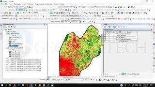
@@GISRSSolution I wanted to ask, how you got the area calculated? -Thankyou
@@ksabmagar5846 I did not calculate area here. These are the total count of each land class. Anyway, for calculating the area, you just convert the Raster to Polygon through conversion tool. It is very simple bro. Many thanks.
@@GISRSSolution Thankyou for your replies. :)
Sir whenever I am trying to create sig it is showing failed to create sig. please give a solution to it. I am using ArcGis 10.8
try to save sig file in default folder that ArcMap automatically recommends. Or close your arcmap and restart your PC and try again. all the best.