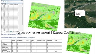
Accuracy Assessment | Kappa Coefficient | User Accuracy| Producer Accuracy| Overall Accuracy

HTML-код
- Опубликовано: 27 авг 2024
- Today I'll show how to do Accuracy Assessment of a classified Landsat Image.
Accuracy Assessment uses a Reference Dataset to determine the accuracy of your classified result. The values of your reference dataset need to match the schema. The most common way to assess the accuracy of a classified map is to create a set of random points from the ground truth data and compare that to the classified data in a confusion matrix. Although this is a two-step process, you may need to compare the results of different classification methods or training sites, or you may not have ground truth data and are relying on the same imagery that you used to create the classification.
Accuracy Assessment Formula
Users Accuracy=(Number of Correctly Classified Pixels in each Category)/(Total number of Classified Pixels in that Category (The Row Total))×100
Producer Accuracy=(Number of Correctly Classified Pixels in each Category)/(Total Number of Reference Pixels in that Category (The Column Total))×100
Overall Accuracy=(Total Number of Correctly Classified Pixels (Diagonal))/(Total Number of Reference Pixels)×100
Kappa Coefficient (T)=((TS×TCS)-∑(Column Total×Row Total))/(TS^2-∑(Column TotalxRow Total))×100
Tags: How to accuracy assessment, accuracy assessment in arcgis, confusion matrix, how to do accuracy assessment of a classified image, Landsat image accuracy assessment, Accuracy Assessment, Kappa Coefficient, User Accuracy, Producer Accuracy, Overall Accuracy, accuracy assessment using google earth, accuracy assessment creating points, Accuracy assessment of an image classification, arcgis accuracy assessment, accuracy assessment tutorial
If you like this Tutorial, don't forget to like, share with your friends and Subscribe my Channel to get more cool GIS and RS Tutorials. Thank You.
#arcgis #accuracy_assessment #GIS_RS_Solution #arcgis_tutorials


You are too good; i can easily understand and make the map...Thanks for saving people☺
Thank you for your nice words.
I was about to comment on a mistake but you corrected it.... The Video was helpful. Thanks a lot👍
Its my pleasure. Thank you.
where is the one you mean mistake? im not realize
Thank you so much, you helped me a lot, my God protect you insha'Allh
Hello, It's really wonderful video. It resolves all confusions while doing Kappa Coefficient using User and Producer accuracy.
I found one thing which is not matching with the formula you mentioned for Kappa Coefficient in this video.
In the numerator, Sigma (column total x row total)
in the Denominator, you shown the formula as Sigma (column total - row total), i.e. at 22:57, instead of actual formula you mentioned in the description box.
If it is Sigma (column total x row total) for denominator, the % of K-Coefficient (87%) is OK, Otherwise, It will changed to 68.90% as per the formula mentioned in the video..
Thank you so much...
Thank you for sharing this video. Very much appreciated!
you are welcome. Please keep in touch.
Cant thank you enough! Your video saved my thesis
you are welcome. best of luck.
Hy. I am from UT Texas Rio Grande Valley and my thesis work is from ERDAS. But i neither could clip the image with shape file nor it gives me the supervised classification details. i do not know why it is not working . Could you help
@@sandipregmi5496 You can watch my videos on Unsupervised classification and also supervised classification tutorial in this channel. You will get your answer.
ruclips.net/video/z6JsedwmPdY/видео.html
ruclips.net/video/aOCcSdcynMw/видео.html
@@sandipregmi5496 ruclips.net/video/z6JsedwmPdY/видео.html
ruclips.net/video/aOCcSdcynMw/видео.html
watch these videos
Excellent video, very useful and complete, as it mentioned all the necessary details
Thank you sir......... You explained very clearly in an understanding way.🙂
thank you very much mr. I really understand now how to accuracy assessment🙏🙏🙏🙏🙏🙏🙏
Wonderfully explained
Thanks you very much
I enjoyed this video it really helped to write my thesis
Its my pleasure brother. Best wishes for you.
Thanks for this good and accurate work
You were very helpful, I am very happy because you helped me understand something that I have to add to my thesis. Thank you so much!! Greetings from Paraguay.
Pd: I think there is a small error in the Kappa coefficient formula, in the denominator it is written (total columns - total rows), the correct thing would be to multiply, right?
Thanks for your nice words. Yeah, you are right. There should be multiply Row and column. It was my mistake. Very sorry for the inconvenient. Butw I have corrected in the attached manual. Thank you again. 😇
Very helpful post.. please make vedios on sentinal-2 related task in google earth engine ..
Thank you for the excellent tutorial.
Thank you
Thank you very much, this was very helpful to me!
You are welcome. Please keep in touch.
Please how do I remove "unclassified" from the output of my classified land covers?
Thanks a lot "A LOT"
Great! pls do more videos about Hydrological calculations
Thank you very much, my dear.
Very informative vedio but i could not know why did you multiply the total row with total column in the denominator of Kappa coefficient as you mentioned to minus the values. Thanks
It was a mistake. It will be multiply the total row with total column in the denominator of Kappa coefficient. Sorry for the mistake. I have updated it in the document. Thank you for your concern.
Very Good and well Understanding tutorial but instead of Using word u should use excel for auto calculations.. nice dear keep it up. I was subscribed your channel yesterday
Thank you very much for your suggestions and inspiration. Thankful to you.
you are the best.
Thank you sir
Welcome
Thank you for this video but I am confused with the minus sign in the denominator of the formula(CT-RT). I tried to calculate using the above formula but sad to say i got different answer.
Thank you. Yeah, It is a mistake of mine. But the mentioned calculation is right. There will be multiple Column Total x Row Total. Thank you.
Can you re-check kappa coefficient formula? will there be minus or multiple sign? Thanks
Thank you. Yeah, It is a mistake of mine. But the mentioned calculation is right. There will be multiple Column Total x Row Total. Thank you.
hello sir how can we do accuracy assessment for 1990s data ?
Can you make a video to find correlation between LULC and Land Surface Temperature (LST) ?
Thank you brother for your interest. I'll do it soon. Keep in touch with this channel. Thanks again for your nice suggestion. 🙂
very informative
plz send file to manojpalaikumar@gmail.com
Wonderful video. Very helpful and explanatory 👍👍. Thank you very much
Glad it was helpful!
Thank you🌸
Thank you so much!
Welcome
Thank you
Which year data did you calculated?
What is the source of the Kappa formula?
You have mixed things, your Matrix is correct, but the researcher collect GPS points ( Ground truth) and compare them with the produced map. you did the inverse. we want the accuracy of the map not of the google map
Thank you very much
Welcome.
how I can perform accuracy assessment of past images (ex: 1990, 2005)??? Google earth don't show past time data. So, how accurate this procedure is?
same question?
Hello...I Have also same question. Did you find any solution? How did you do accuracy assessment of past image which is not shown in google earth ? If you see this comment Please help!
google earth pro has but where you can move through years
Same to me bro,,,if have find it ,send to me ,I will be appreciated
Hi Sir. Can you refer to the reference of the text you used in this good explanation, please? I will be so grateful.
Hello sir
Could you kindly share with me the Excel sheets you were using I'm currently doing a research that needs the accuracy assessment
email id please
kindly share this sheet sir.
Hi! Thank you so much! can i get a copy of the sheets?
Merci bcp
Thank you,which do you recommend for this accuraccy assessment ERDAS or Arcmap
Both are okay. You may use according to your expertise.
thnk u 👍
Thanks for the video; it is helpful. Could you please send the word file? I would like to cite you in my ongoing dissertation properly
Thanks
Welcome brother.
thanks for the video.
please, how we can determine the required number of points (random points or sample size) to make the process of accuracy more accurate and reliable? is there any formula or method?
Tqvm
Welcome brother. Sample points/ground truth data depends on your study site. But it is suggested that you should take random point as many as possible to get accurate result. I did not find any formula to select sample size. In Summary, You should take random sample point as many as possible ( for example for a City like Dhaka you can take around 50 sample points for each land class). Thank you brother for your interest.
@@GISRSSolution Thank you so much
@@raidanmaqtan2652 You're Welcome 😇
Spatial reference for my file shows unidentified.. what to do sir
hello sir, please send me the copy of the sheet.
I tried to generate the kml file but when I open in google earth it's error. it shows "failed: Parse error at line 10, column 2:
" do you know what it means and what could cause the error? I've put the correct coordinate though
It is a technical issues. Please uninstall your google earth and then reinstall. Hope it will work. Thank you.
How to do accuracy assessment of the historical image which is not available in Google earth, like 2000? Please help!
Some potential sources include historical aerial photographs, topographic maps, satellite imagery from other providers, government archives, historical land records, and historical reports or publications.
Also you can Establish a set of reference data for accuracy assessment. Reference data typically consist of ground-truth information against which you can compare the LULC classification results. This can be done through field surveys, historical documents, expert knowledge, or existing data sources that provide reliable information about the LULC during the target time period.
hello can you give me the reference of the formulas you used?
Thanks so much for this video!!!
Please I am mapping marginal land in Europe using open source datasets like Corine land cover, Pan-European High Resolution Layers (HRL) tree cover density, Natura 2000 network , DEM, European Soil Database Derived data etc... please do you have any suggestions as to how i can go about accuracy assessment for this please.
You can check accuracy either google earth image or take ground truth data (reference point). Thank you.
I really would love to get the manual of this
novena515@gmail.com my email address. Please, send it to me
How to draw the accuracy point on google earth?
There should not be minus in the kappa coefficient formulae, (in the denominator part, isnt is column total * row total), thamkyou?
There are some others formula to calculate Accuracy. This is one of them. Could you please correct me if there is a wrong in this formula ? Thank you for your nice cooperation.
Thank you. Yeah, It is a mistake of mine. But the mentioned calculation is right. There will be multiple Column Total x Row Total. Thank you.
I have a question, can i ask you?
sure
I found the solution, actually it was my mistake that's why i don’t understand a thing
Can you do the Google earth thing with a 2020 map?
please send me the research paper or document of the formula
Can I use this accurachy assessment for may ndvi classification?
Yes, You can use.
THANK YOU MATE, I need the word file please!
is conducting Maximum Likelihood a mandatory or not necessary? i am confused please help me.
You can do LULC using supervised or unsupervised classification method. You know there are some other options as like maximum likelihood algorithm. So it is not mandatory to use this method if you use another one. It's up to you. If you need any further clarification, feel free to ask me.
@@GISRSSolution Oh my thankyou so so much. I am doing a lulc for my research paper and I was watching videos but all have different methods to do it. by far yours is easy to understand. in your opinion what kind of method is the best to apply Sir??miss I am sorry I don't know how to address you🤗
@@BLUE-hu5df Thank you for your appreciation. I am really glad that you find that easy. However, Have watched my Supervised and Unsupervised Classification video on LULC? Both are okay. Most of the researcher are using Supervised classification where they use Maximum likelihood option to do LULC. I suggest you to do Supervised classification using Maximum Likelihood for your LULC. Anyway, you can address me brother. :) Best wishes.
@@GISRSSolution Thank you so much for replaying brother I will continue with maximum likelihood then. And I will check your video on supervised claasficatiom as well.
Good 🙂.....but There is confusing..Kappa coefficient formula.... Refrence books Pls???
will try to attach reference in the description section. thanks for your comments.
Sir, can you give this word file to me or us? it will be too much helpful for us .
Thank you for sharing this video. Very much appreciated!
But #chriss_lewis
Asked "how do you get the number of samples?"
You replied .......take the samples using google earth or visiting the locations or from topographic map. I have taken the samples using google earth.
.......I got confused with that. User points and producer points will be the same because the user points(collected from google earth) are going to checked with the google earth map. How is possible? need help please.
Can I please get the sheet!
How to determine TS ? Thanks
Here, TS means Total sample. It depends on you how many samples you will take.
@@GISRSSolution Sorry I want to ask you again. I have 75 plots sampel. I used that sample to make carbon stock estimation model. I used 50 plot to constructing the model and 25 for validation model. and the end, I would calculate the cappa and overall accuracy. as a producer data I use (25 plot sample I used to validation model). can I use all (75) plot sampel to calculate cappa and overall ? or just use plot sample existing I used to build the model ?. Thanks I hope you answer the question
Can i get the sheet?
Please I need the sheet
how do you get the number of samples?
You just have to take the samples using google earth or visiting the locations or from topographic map. I have taken the samples using google earth.
would it be possible to obtain your doc file? Thank you very much
wuwu, did not receive anything. Plz. doctordego@gmail.com
@@w.w.8951 sent u. Please check your mail. Sorry for the late sending. Thank you.
@@GISRSSolution please send me the doc file at mshakeel133@gmail.com
Plz Sir Send Me The Formula
can i get a copy of the sheets?
Click* click* click*
Could you please send me this word file I need this for my research work my email I’d is
Your email id please
@@GISRSSolution Can you Also send me word file
VERYY HELPFULL OMG IM SAFE FROM DEATH BECAUSE THIS INCRADIBLE VIDEO. THANK YOU VERY MUCH FOR ANYONE WHO MAKE THIS VIDEO GOD BLESS
kindly share your email id please
Thank you Sir
Thank you sir