Traditional Nautical Chart Navigation - Course P.S.C.

HTML-код
- Опубликовано: 10 сен 2024
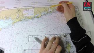
- Learn how to plot a course per standard compass on a paper nautical chart from the experts at U.S. Captains Training. Captain Neil Smith demonstrates finding points using the longitude and latitude scales, taking proper measurement on the compass rose with parallel rules, and converting degrees True to Compass. Practice along on a 1983 Block Island Sound chart to prepare for your upcoming U.S. Captains Training class and test.


You just won me a $200 bet at my job! 😂😂 thanks for the video!
Thanks for the videos. I learned PSC means “per ship’s compass”. I feel that makes it easier to differentiate between magnetic and the ship’s binnacle mounted compass.
This is a good summary of a how to read a nautical chart class basically for anyone that has already reviewed the material but wants kind of a quick and simple understanding/refresher. This is probably not best for someone who has no idea that a parallel ruler even is.
I had no idea before I watched this but now I get it....
That's right..I don't know anything about sea charting..I'm going to have to look at something like..'sea chart reading for dummies'..is there such a vid?
Damn! Captain Neil Smith is clear as a bell. Studying for my 'Boat Crew' training for USCG-Aux.
These videos are so clear and concise.
GPS and electronics can fail you. It's good to have this knowledge, and I understand parts of Europe still have running lighthouses.
He has True at 070' which is correct.(although he has forgotten to mention ALL bearings are 3 digits long - such as - 002', 098', 343' etc. This would read as 070'T. On the compass rose there are two Norths (Magnetic and True). On the Magnetic line there are some numbers (Variation,date of chart and Deviation). At 3:52 he says a very specific Variation making the assumption all charts have only one compass rose, this one says 015'V. The old saying is: Grid to Mag we add. 070 + 015 = 085'M
Mr. Parkes, the compass rose does not speak to "deviation", only "variation". Deviation speaks to the magnetic interferences aboard the vessel. When we strive to "nit-pick" let's make sure we actually know what we are talking about. I do agree though that when someone sets out to teach others,
their knowledge and terminology, especially in a subject area such as navigation, should be accurate .
It is the function of each generation of teachers to make the simple ever more complex and to introduce complexity where there was none before. They do this to make themselves sound smarter than the teachers who went before them. Therefore, study old books, not new teachers. :o)
thanks ill be checking these videos all weekend!! keep them coming
While calculating compass course from magnetic course you require deviation card. But when you look at deviation card you will first column as compass heading and second as deviation and there is no magnetic heading. Thus to calculate compass course, we need to calculate compass plus minus deviation to get to magnetic, then interpolate to get the exact value. Thus there was error when he calculated.
SWEEEET! Nice video! Tought me alot!
funny how the adjective "traditional" is used. this is how we navigated passages in the 80s. pilotage skills. we practiced traditional sextant daytime/nighttime positioning. the faster you could fix a position, plot a course made good and execute a corrected course to your desired destination, the more masterful a midshipman you were. GPS was just in its nascent stages in our part of the world then.
very direct. solve's 95 pct of all nav problems!
Very helpful video. Thanks!
Thanks, Neil ver y informative.
If this guy teaches US captains how to navigate, that would explain a lot! He is correct up till 1:34. Then he takes a distance line from the Latitude of point 'B', should have taken it from a parallel position from point 'A' So he is now 1/2 mile out. 1:39 - 3:03 is correct but he forgot to mention we have to find 'True' first. So at 3:03 assume he is finding a True bearing. At 3:43 he starts to miss crucial steps. T.V.M.D.C. stands for True, Variation, Magnetic, Deviation and Compass.
using the dividers, since the ends of his have points, he is making a small hole in the chart so he remembers where to place his marks (start/end marks).
Capt. Bligh navigate with just a sextant and a watch...how ? ( after he was marooned in the whaling type boat)
Very interesting!
He then finds the Deviation which is 002'E (This is where he has missed the 'date of chart' which explains how much deviation there is per year. Which is why he got 083'C. If he had looked at the 'Date of chart' and subtracted the actual date. For instance: If my chart says 2012 and it is now Sept 2013. That is 21 months since chart datum. His is 002' so he should add three months (3/12 = 1/4 OR .5') to make it 002.5'. This would make the answer 082.5'M. 4:51 You've hit the rocks and sinking!
Because of the camera setting and bad audio it is impossible to follow
i wen to lean more on longitude past
Would be better for the student to visualize if you also make a draw with the ship's heading(s)
+martin parkes
You are wrong on at least two points.
1 minute of latitude on a mercator chart = 1 nautical mile.
"latitude of point A" and "parallel position of point B" will give you the same distance, 1 nautical mile per 1 minute of latitude.
For the purpose of this exercise, he is assuming the variation to be 15W because the variation is assumed to be 15W on this specific chart for the USCG exam.
(he states this point clearly)
Also, the date of the chart has absolutely nothing to do with deviation.
Deviation applies only to a particular Ship's Head Compass and is based on the magnetic influence that each individual ship has on the reading of the Ship's Head Compass based on heading.
I am watching this video because I am in the process of learning basic chartwork... and I spotted your mistakes immediately.
Hopefully you don't confuse others with your ignorance.
Seriously, why the correct answer is 82.5, or why his calculations are wrong?
82.5 and 83 isn't big D. but on the actual exam if you'll pick answer like so it is going to be = Fail...
Unless deviation table are wrong...
Make an indent??
True Virgins Make Dull Companions
No chance ill forget that...cheers
I'm never going to pass Plotting Charts!
dupa dupa ddddddddddddddddddddddddddddddduuuuuuuuuuuuuuuuuuuuuuuuuuuuuuuuuuuuuppppppppppppppppppppppppppppAAAAAAAAAAAAAAAAAAAAAAAA
How in the hell does anyone ever figure this stuff out? Do the current computerized plot charters eliminate all of this long haired mathematical huma huma?
Is there a book Learning to plot for dummies...just seems so complicated.
craaaaaaaaaap
sound quality very poor
holy shit.. we only use triangle rulers fuck..
So many are just letting some computer do their work for them that these VITAL SKILLS are being eroded away, or even lost altogether!
And THAT'S just nutz!
Yes, my plane has automated flight management systems!
BUT unlike todays youth, I was TRAINED to fly the plane MYSELF! Not to be the dummy that tries to "Program" a computer to fly my sorry arse around!
no
Layla song
what a nonsense video no one can understands just like eplained