Earth’s History Is Hidden in These Strange Maps

HTML-код
- Опубликовано: 13 окт 2024
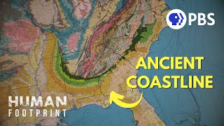
- The Channeled Scablands of the Pacific Northwest hide an astonishing secret. Evidence of a massive flood that shaped the entire region lies just beneath its landscape. But it can only be seen with cutting edge LIDAR technology. Join Joe as he learns how scientists are using lasers to reveal details that may help us predict the paths of potential megafloods of the future.
Hosted by Joe Hanson from Be Smart, Overview uses stunning 4k drone footage to reveal the natural and human made marvels shaping our planet--from a 10,000-foot view--literally.
*****
PBS Member Stations rely on viewers like you. To support your local station, go to: to.pbs.org/Dona...
*****
Subscribe to PBS Terra so you never miss an episode! bit.ly/3mOfd77
And keep up with PBS Terra on:
Facebook: / pbsdigitalstudios
Tiktok: / pbsterra
Instagram: / pbsterra


![Clave Especial x Fuerza Regida - No Pasa Nada [Official Video]](http://i.ytimg.com/vi/3u2jaju71IQ/mqdefault.jpg)

The Channeled Scablands are one of my favorite subjects. And I absolutely loved that you discussed Joel Gombiner's work with LIDAR and Skye Cooley!
Joe.Biden.gov/remembers/it/well
Honestly I do enjoy Randal Carlson. He is friends with that slightly wonky guy so he gets ignored but his research is well read, non college expert on the flood.
if this has piqued your interest,
may I suggest you hunt out Prof Nick Zentner from Central Washington Uni.
he has a tube'y'all channel in his name and has been telling the story of PNW geology
for almost a decade.
all the names you heard here and many others are part of that story.
Thanks, I was just going to comment that I’d like to see more about the creation of the Scablands, it’s so fascinating!
@@astrumrimor2450 off you go! Prof Zentner is a very engaging teacher. I hope you'll like what he has to offer.
Thank you.
Prof. Zentner is awesome! 😻 [Edited to clarify:] I've never been his student, but I've watched hours and hours of his videos.
Shawn Willsey also has a RUclips channel where he has talked about the erosion of the glacial or pluvial Lake Bonneville floods in southern Idaho and northern Utah.
I initially learned about the scablands from @TheRandallCarlson . Fascinating place!
And boy were he and Graham Hancock in his book America Before ridiculed for it.
@@melaniebrouwers452 he still is. The Palouse Loess is the fallout from his hypothesized impact. 😂
As a Geophysics and Geomorphology student, it's very fascinating. Thanks for the informative ride!
What do they teach you?
@@donna9679 Anything about Geo
I'm always baffled when I see people building buildings in river bends in what are very visibly floodplains. Farms I get, that's fertile soil. But then sometimes you see very expensive multistory buildings being built on temporarily dry riverbed. Castles built on sand.
and because they build there, flood waters have nowhere to go, making the damage even worse
In part it's a refusal to learn from indigenous land use. If you need to build on a floodplain, you put the house on stilts--you don’t build it at ground level where it will be washed away in the next flood.
Yeah, cause the people that have the money and power to build things like that are usually either stupid or corrupt, or both, so they build what they can and get their money from the project and then get the hell out of there and don't worry about the long-term consequences. And the people who are in charge of making regulations to prevent things like that are just as corrupt and stupid. And that process is repeated in many ways in every industry over and over. And that's pretty much why the world has gone to hell in a handbasket and in particular the US has become a failed state.
Las Vegas, NV, has had huge floods back in the day. Entire first floors of casinos were flooded for days. Those casinos paid so much money into flood control after that.
Nick on the rocks! He taught us this a few years ago. Looks amazing through lidar.
This presented the new research from Joel Gombiner et al that Nick only shared this past winter and spring!
@@AvanaVana The new details are great.
In about 1970 I was briefly involved with a bridge design in Papua New Guinea lowland rainforest over a river that had meandered over aeons. Choice of crossing point was done by finding old channels below canopy using visual aerial photography. Bridge was placed where all the old channels went through a single pinch point near an outcrop. LiDAR would have been useful.
Good to see Joel Gombiner presenting his research and Skye Cooley mentioned!
Along with the macro topography of the area, I found the potholes surprising. Usually about 20 feet wide and 6 to 10 feet deep with a large rock sitting at the bottom. My time working in the scablands was fascinating. I spent a good portion of my work life in the Pacific Northwest and the time along the northern border of Washington and Idaho has stuck in my memory. Much more topographic insight has been provided concerning where I grew up -- along the lower Columbia River. Thank you for this story.
Love maps and would love to get a set of LIDAR prints of the entire globe. Looks like it may be a while before those images will be compiled. Every country needs its own LIDAR Dept. . . . "So let it be written. So let it be done!"
might be off-topic, but the fact that drones are now basically standart for "cheap" filming is amazing!
because the cost has gone down, same thing with phones and laptops compared to decades ago
LiDAR is awesome tech.
Archeologists discovered ruins of Mayan towns in the jungle with LIDAR.
LIDAR is opening our eyes to literal history in every respect. How awesome!
Hey Joe! Joe sent me :)
HELLO hi welcome, nice to see you here
Same XD
Same 😂
Same
Same 😅
My mom grew up right on the edge of the channeled scablands and then met my dad moved literally across the country to GA and NC but she always told me how amazing they are and I really hope to take my kids out there one day and see them for myself
That's just not how life works. Hoping doesn't make things happen. Nor does really hoping. Saving your cash. Researching the cost of renting a car and flying out vs driving, practicing camping skills near home, saving up vacation days, turning "one day" into a feasible date...these are the skills of making things happen.
Super wish you would have had Nick Zentner in this. He's incredibly knowledgeable and passionate about the formation of the scab lands.
Other than that, this was great, and it was wonderful to see where I grew up shared with others. It looks barren and dead, but it's really a beautiful, awesome place.
Nick Zentner is a national treasure
Nick is king!
The Channeled Scrablands truly are a world of theyre own
A world best viewed from above
It's remarkably reminiscent of my dreamscapes😮
I live in The Willamette Valley. Where the Missoula flood occurred. This video is amazing. I truly believe LIDAR will unlock so much information & allow us to advance our knowledge like never before
It wasn’t just “A” Missoula flood - it was dozens. The ice advanced, flooded the Missoula valley, broke and advanced again, over and over again for centuries.
There were at least forty Missoula floods and hundreds of other glacial floods.
The Willamette valley soil used to be the rolling hills of the Palouse before the flood waters moved it all. You’re welcome!
@@allangibson8494 you are fully correct. I didn't mean to word it where I sounded like only one event happened. It's such a fascinating chapter in history. I'm so curious what it would have looked like around the valley when they said there were little islands all around whenever the valley was flooded
These images are so amazing! I'm genuinely in awe at nature's beauty and science.
I'm from WA and have visited the area, including Dry Falls. If any of you ever get the chance to pass through the region I'd suggest taking a stop to check it out. It's very cool to see in person. There's even a neat little visitors center that covers the history of the site. The region also has some great reservoir lakes in these valleys courtesy of Grand Coulee Dam. The lakes are great for camping and boating with amazing views, and the dam is a sight to see too. They do this cool laser light show on the spillway at night, or at least they used to, it's been a good long while since I visited.
The glacial lake Missoula outbreak wasn’t a once off. Geological research indicates that it happened at least forty times.
Home! Channeled Scablands, most my life I've lived in the middle of 'em. Always been fascinated.
Ditto to the previous comments. Folks should be aware that these were a series of floods and not a single event. See Nick Zentner's A to Z programs on the history of the floods and J Harlan Bretz. 😎🦋 Namaste
The thought of the glacial Lake Missoula flood happening in _hours_ (or even days!) is really mind blowing.
This is absolutely amazing and beautiful! Thank you for explaining the LIDAR.
This makes a good counterpart to the PBS Eons episode about the Glacial Lake Missoula flood.
Amazing work in bringing these new developments in the old and amazing story of Missoula lake and Channeled Scablands to us this fast; thanks!
Beautiful 😍 I love how LIDAR is impacting so many sciences right now.
Please refer to the work of Randall Carlson regarding floods from Canada.
Why would they misinform people by pointing them to Randall Carlson?
Is he some sort of a conspiracy theorist?
Randall Carlson anyone?
Totally. Any discussion of the Channeled Scablands should not overlook the work of Randall Carlson.
I thoroughly expected him to pop up
Geoscientist here.
Hate to disappoint you but simple melting at the end of the ice age due to seasonal variations adequately explain the various flood pulses. Pools of meltwater collect behind ice dams that can suddenly give way. Handcock is a psuedoscientist, so he leans towards the overly dramatic; unless you envision many regular impacts🙃.
R. Carlsson, although somewhat misguided about many things, is more restrained and humble than sensationalist Handcock, don't be fooled by his British accent. Like many conspiracy theorists, he uses facts as a base to scaffold an entirely inaccurate conclusion. Hence his deranged early civilisation hypothesis. Carlsson is merely flotsam caught in the flood of bullsh*t Handcock pushes. Excuse the pun.
This phenomenon is already starting in E. Greenland, where I have conducted research. Jameson Land.
@@gregb8649Randall hasn't done any work in the Scablands. He does tours.
He is a good charlatan.
The study of the past is never over! I watched this video in the past.
Nature is the ultimate artist! Okay here’s my list of places I would love to see LIDAR tackle: Tunguska…The Richat Structure and surrounding area…The Great Lakes especially Lake Erie Northwest Ohio…Rama Setu…Mongolia…Himalayan Mountains…Black Sea region…key areas along the Tigris and Euphrates Rivers…Lake Titicaca and surrounding areas…The Ohio River Valley…
So many places to be curious about!
Yellow River, Yangtze River, and other rivers in Asia
This is awesome. Great video and great work to all!!!
It would be very interesting to find out what’s under the dunes in the Sahara Desert.
You do realize of course that the Sahara (and all of North Africa for that matter), was the site of a mega-flood many times larger than the "Missoula Floods".
@@ronanzann4851 this is especially why it’d be extra super duper amazing to see Lidar there… those ripple marks you can see from space near the Richat Structure too!
@@ronanzann4851 citation required.
I would be very very interested in LIDAR maps of Mars...
I wonder how much it would help since there is no vegetation to look though. Maybe it would help in other ways, I don't know!
pffffffft ... seriously...research fake "space" and travel...the world is NOT what we have been told...NASA and disney were "formed" with the antartic treaty to take our minds off exploring outer lands..!!!
Also in Texas, there was a flooding event in 2000ish and it made some new questions about how quickly canyons could form. Long thought to be a slow process, a damn overflow from Canyon Lake carved a 10 mile long 50ft deep canyon, and a bonus, there were Dino tracks uncovered!
This is how the Amazon is being investigated and finding tons of buildings not found before.
Excellent. I first learned about J Harlem Bretz in 1980 when I was a geology grad student. There was a NASA conference on Mars geomorphology in early 1981 and an abstract volume was put together for that conference, which took place on the campus of LSU in Baton Rouge, LA. I was sent to DC by my prof to help put together the abstract volume: I spent a whole week at NASA HQ in downtown DC. There were many abstracts about the channeled scablands and the analogy with Mars channels which NASA had recently begun to “map” with the first Mars rover.
And then there’s late glacial catastrophic flooding itself. Many catastrophic floods took place in late glacial times across the world as the ice caps retreated. Many of these are recorded in “myths” of ancient people, a.o. the great flood described in the bible. I wish you had mentioned this as well in the video though I realize the focus of the video is LIDAR technology.
This is so cool. Yay Daniel Coe, Joel Gombiner & Skye Cooley!
At 0:24 It perfectly sums up.How I react when talking about the subject, for I know nothing
Oh my gosh thank you!!!!!!!! I have been absolutely fascinated with the scablands for YEARS. I live in western wa! Can't wait to finish the video (:
I was so hoping the Missoula floods would be covered and I wasn't disappointed. Love this kind of science.
I learned about LIDAR technology in my Introduction to Archaeology class back in 2021. It's super cool! I remember telling my professor that the maps look like resin art or watercolor paintings.
Hi all , Omak is home to me and grew up thinking the hole valley looks like a dry lake bed with the rings around the edge, rocky mountain on one side broken up by massive ice flowing, lots of very large boulders from Canada scattered all over. It was all under water for a long
I adore the scablands. Our geology claswa would go out there for field study. Thw Missoula floods are some of my favorite pieces of PNW geologic history. It's so exciting to see new depth!! Thank you for covering it!
Using the ripples left on the land to calculate volume and velocity of ancient megafloods is just amazing. Science!
I have to admit I though some of them were painting. They are art's of work I would buy.
This kind of stuff is totally up my alley! subscribed
As a geologist over 40 some years I went from estimating locations on topo maps to gps and lidar, that I managed to learn to process myself. Lidar is a wonderful tool, but one day I realized that I did a lot of mapping before lidar that was instantly obsolete! And, yes, lidar is good for bedrock mapping too.
So much potential in the future possibilities. - Excellent production, at every level. Well done, All. Thank you 🪔
I don't really have the words to express how deeply I appreciate that you keep on your profoundly beautiful work to enlighten us - I think you should be cloned a whole lot of times, dear Joe!
You've been a most welcome addition to my feed for something like a decade by now, and you have contributed heavily to the perspective in which I see the world that I'm a part of!
(And please do look it up, and show it to tje otherwise great Green Brothers - by definition a perspective is something you see something IN! Not from! You - by definition - do not see something "from" a perspective! You see something IN a perspective, regardless of what side of The Pond you pick your dictionary. Look it up! If Britney Spears could get it right, I'm confident that with enough loving insistence, even the Green brothers can learn to speak a proper English, whether it's American, Mid-Atlantic, or just nice everyday use of their first language)
Lots of love from Denmark 🤗
you said that the light from lidar can "remove trees and buildings" from the imaging... but how exactly? what kind of light can actually pierce through all that material and still reflect off other substrates?
we need a part 2 with far more details on how exactly lidar works... and MOAR of those pretty maps!
LiDAR works by shooting laser beams and measuring how long it takes until they are reflected back to the sensor by whatever they hit. Since a few hundred thousand of these thin laser beams are shot out every second a few of them will always find their way through small gaps in the vegetation and gather data about the ground below.
The removing happens in the post processing after the data is gathered. LiDAR produces a point cloud which is then classified into ground and non-ground (i.e. vegetation and buildings) by different algorithms. To create a bare-earth digital surface model (DSM) the non-ground points are removed and resulting holes are filled via interpolation from the surrounding ground points.
@@jannism1798 yea i kinda skimmed the wikipedia too, i just want this in a video with pictures and joe's narration xD
That's sooo amazing! I live in Carinthia (southest county of Austria/Europe) and here the Drau-Glacier shaped the landscape at about the same time the Cordilleran ice-shield exists. And i "see" supposed potential floodwork here everywhere - of course way smaller scale than Washington and Idaho. But in fact i don't know if there where any. We have less data. And we have no amazing Nick Zehntner teaching about Carinthia (because of him i know more about Washington than about my own country). But LIDAR could do this amazing work.
After driving from Kelowna back to Wenatchee I am convinced there was at least one super mega flood and lots os these smaller mega floods
One TV show had a theory that a lost crater impact in Canada is one of the initial triggers for a mass flood from both the Okanogan area and Missoula area. Same time.
I didn't know that the Okanagan region had different spellings in Canada and Washington (Okanogan)
@@GreatOrigins depending on which side of the border it is spelled differently. in USA "Okanogan County" in Canada they change out the O. it gets confusing.
I own a modest ranch in central Texas. Recently I saw a video concerning USGS and LIDAR surveys. I was able to find, on the USGS site, a survey of my little slice of Texas. Kind of like a Goodle Earth display. Of course I know the terrain pretty well, but the LIDAR survey was interesting.
Wait wait, there's a second Colorado River ... and it's in Texas?
Colorado is just Spanish for red or ruddy, so the state was named after the river that the Spanish had simply named after its usually reddish hue and it shouldn't be surprising that there are other rivers in the southern US that are also named Colorado as a result.
@@marksando3082In other words, yes.
I worked on an airborne LiDAR syste that does stuff like that.
now i want a hand held version of one of these things... imagine scanning your own cliffsides and stuff
Fun fact: Another such event is in central asia. It would have been *the largest flood* during the ice age. I think the Missoula floods come in second or third place.
Not just the scablands, but the the huge cliffs along the Columbia Gorge. I think you said you were in Washington, but the pictures you show are very much like the Clarno Basin in Oregon - not surprisingly.
Wow! Fascinating! More Please!
I wish someone would apply that technology in the Yucatan peninsula to see the meteorite and Maya history. That would be awesome! 😊
We even had lidar way back when I was in college. I'm a geologist, specifically a sedimentologist and graduated with both BS and MS in the 1970s. This is just geologic history being uncovered. Not new, but still fascinating.
My attention was really caught by how LIDAR could definitively reveal all of the ancient flow channels in river valleys, including in areas currently occupied or developed, which means that those areas will eventually flood again resulting in loss of life and property. These results are incontrovertible proof that provides the tools that governmental authorities can rely upon to prevent further development.
I got real hype when I recognized Joe from Smarter Everyday's voice.
Those LIDAR images are insanely beautiful.
Randall Carlson has entered the chat
Geoscientist here.
Hate to disappoint you but simple melting at the end of the ice age due to seasonal variations adequately explain the various flood pulses. Pools of meltwater collect behind ice dams that can suddenly give way. Handcock is a psuedoscientist, so he leans towards the overly dramatic; unless you envision many regular impacts🙃.
R. Carlsson, although somewhat misguided about many things, is more restrained and humble than sensationalist Handcock, don't be fooled by his British accent. Like many conspiracy theorists, he uses facts as a base to scaffold an entirely inaccurate conclusion. Hence his deranged early civilisation hypothesis. Carlsson is merely flotsam caught in the flood of bullsh*t Handcock pushes. Excuse the pun.
This phenomenon is already starting in E. Greenland, where I have conducted research. Jameson Land.
@@allistairneil8968 Are you experiencing numbness on one side of your face or body?
Grifter
Randall Carlson has left the chat...
Randall isn't a geologist nor has he contributed anything to the work done in the Scablands.
@@swirvinbirds1971 that’s not true he was on the Joe Rogan experience
Colorado river, Texas; not far. Very nice presentation. tu
Hey! I live there! Dry falls is really cool!
Absolutely amazing to learn about things that happened before our society even existed and how it will continue to go on even if we do something to destroy ourselves.
That stuff is absolutely amazing
I don't quite get how LIDAR works; visible light is blocked by vegetation, so why can LIDAR "see" through it?
It uses UV, visible and/or infrared light to pass through the vegetation and bounce back to the detector. The type of light used depends on the use you're using it for.
The LiDAR doesn't penetrate vegetation, but due to the density of the points, some will pass through gaps in the vegetation. This gives enough points that the surface under the vegetation can be interpolated.
Typical aerial lidar uses either "green" lidar at 532 NM wavelength or near infrared at 1064 NM wavelength. Where the green lidar is able to penetrate water where the NIR lidar is absorbed by water. When a sensor is active it is receiving multiple returns or reflections from the ground at the location the laser hit. Those returns correspond to anything that is between the sensor and the ground like trees, grass or fences all with different intensities. The ground return is typically considered whichever return is the strongest return in intensity.
This pdf by NASA explains it pretty well
www.google.com/url?sa=t&source=web&rct=j&opi=89978449&url=appliedsciences.nasa.gov/sites/default/files/2021-03/SIF_LIDAR_Podest_Final.pdf&ved=2ahUKEwjKot74k7GHAxW3xskDHTo8DZUQFnoECBgQAQ&usg=AOvVaw0C0gQNF93gyd2Z96v8Ci_w
It's all about the wavelength. Same way different wavelengths of light get filtered out by water progressively as you go deeper with the reddish end of the spectrum getting filtered out first and blues penetrating the deepest.
@@LupinoArts
Aerial lidar typically will be green lidar with a wavelength of 532 NM and near infrared or NIR that has a wavelength of 1064 NM. The sensor will read the multiple returns from the laser pulse and the one that has the strongest intensity is considered the last return and is processed to be the bare earth surface. The other returns are classified as things like canopy, structures or noise. There are 5 different qualities of lidar from QL0 which is the highest quality to QL5 which is the lowest quality. The qualities are based on pulse spacing, vertical error and digital elevation model cell size.
NASA has a nice little pdf that explains it and has some cool graphics. Search for The fundamentals of lidar on the googles or NASA.
I remember Joe talked about this flood in his channel, this video showed a different perspective of that deluge.
Awesome video, learned something new, keep up with great work ❤❤❤
Here from It's Okay To Be Smart. Hi Dr.Joe!
Several decades ago I was making general conversation with a client when we were discussing radar technology and he casually mentioned that he was working on light ranging imaging he called LIDAR. Knowing nothing about light energy I didn't question him about it. These images are truly breathtaking.
Any time I see a new video ft. Joe, I am pleased ESPECIALLY when I have a new channel to sub to!
Brilliant work - Suggests that Hancock and the meteor notion could well be correct.
Nope. Geoscientist here.
Hate to disappoint you but simple melting at the end of the ice age due to seasonal variations adequately explain the various flood pulses. Pools of meltwater collect behind ice dams that can suddenly give way. Handcock is a psuedoscientist, so he leans towards the overly dramatic; unless you envision many regular impacts🙃.
R. Carlsson, although somewhat misguided about many things, is more restrained and humble than sensationalist Handcock, don't be fooled by his British accent. Like many conspiracy theorists, he uses facts as a base to scaffold an entirely inaccurate conclusion. Hence his deranged early civilisation hypothesis. Carlsson is merely flotsam caught in the flood of bullsh*t Handcock pushes. Excuse the pun.
This phenomenon is already starting in E. Greenland, where I have conducted research. Jameson Land.
Excellent video!
Liar is extremely cool. South American LiDAR maps show many cities that were invisible before.
I'd love to see someone compare the LIDAR of the Scablands with those of the English Channel. Both were likely created by the bursting of a glacial lake. The difference obviously is that the Scablands re-emerged from the water and the Channel didn't.
The DEMs (digital elevation models) created using the LIDAR imagery are breathtaking
That place should be a national park. There’s plenty for everyone to see and learn in a place like that.
This is unbelievably amazing! Thank you!
I’m a geospatial analyst and have worked with imagery like this. It’s very fascinating.
I saw those ripples flying into SEATAC in back in 17. Glad to see good maps of it now.
i drove trucks around the u.s. for about 20 years or so and could make out tremendous alterations too, further south. nevada shows signs of something big
Please make video about Laser Scanning Technology... particularly for landslide or other geo hazard analysis
Why characterize the forces as "violent"? Why not dynamic, forceful, turbulent? I see creativity or reshaping, not destruction.
Probably because it could kill you? That seems violent. But it is also super cool and you got a point. It can be both.
Why care?
I didn't know there was a Colorado River in Texas. That could be confusing! Thanks.
Me either. I had to look it up.
Are prints of those LIDAR scans available? Gorgeous
Interesting. Thank you.
I wonder if there are any large water sources associated with the Greenland or Antarctic ice sheets that could suddenly generate mega floods. Especially regarding Greenland, a sudden, massive influx of freshwater could shut down the AMOC.
i dont know if its cause im a nerd but i can usually see the old flood plains of rivers with my naked eye, even ones my geo professor didn't think were some
Awesome!
I love this stuff
I'm only two minutes in, but if they refer to that river as the "Colorado River" one more time without justification I'm going to LOSE IT.
Fabulous video!
Randall Carlson has been talking about the scabland for years I'm glad technology is proving his hypothesis
I'm lucky enough to live near the channeled scablands. I think I will take my daughter on a road trip to dry falls. She loves the story/history of lake Missoula