Backpacking Jasper's South Boundary Trail

HTML-код
- Опубликовано: 16 июл 2024
- Have you ever been “out there”?
That’s what it felt like, halfway through our 7 days on Jasper’s South Boundary Trail. We got the distinct impression that we were out there, alone, no other humans in the remote southeastern corner of Jasper National Park in Alberta, Canada. For the last 6 days of our hike we saw no one.
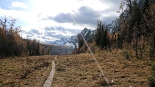
Hike along with us as we backpack Jasper’s historic South Boundary Trail, from the eastern edge of the park all the way to the western trailhead on the Icefields Parkway.
NOTE: This is a condensed version of my original 75-minute video entitled “Walking with Grizzlies: 7 Days on Jasper’s South Boundary Trail”. So, there's no bad joke near the end of this one, lol.
0:00 Intro
1:33 Day 1 ... trailhead - Medicine Tent camp
4:32 Day 2 ... Medicine Tent - Cairn Pass camp
9:17 Day 3 ... Cairn Pass camp - Cairn River camp
12:57 Day 4 ... Cairn River - Isaac Creek camp
19:38 Day 5 ... Isaac Creek - Brazeau Lake camp
23:49 Day 6 ... Brazeau Lake - Waterfalls camp
29:10 Day 7 ... Waterfalls camp - Icefields Parkway trailhead
31:48 Epilogue
Music: “Wild Soul” by Reveille … licensed through Soundstripe HJ8Z5JCC2VXZECFZ
This is a list of some of the gear that I use on my hikes, and their affiliate links.
As an Amazon Associate, I earn a commission … a little bitty teeny tiny one … when you click on any of these links and purchase the item(s) from the link(s).
Using these links makes it easier for you to find (what I think is) great gear and costs you nothing extra.
EVERY nickel, dime, quarter, or dollar that I earn in commission I turn around and donate … 100% … to the JDRF (Juvenile Diabetes Research Foundation) in support of research for treatment of Type 1 (insulin dependent) diabetes, which our daughter was diagnosed with when she was 4 years old.
Thank you for YOUR support!
Canadian Rockies Trail Guide (Patton & Robinson) … amzn.to/3TxAZwL
Osprey Atmos AG 65 backpack … amzn.to/4986PWM
Marmot Helium sleeping bag, rated to -9C … amzn.to/3x5IGD0
NEMO Tensor Ultralight Insulated Sleeping Pad … amzn.to/4arvKWl
Columbia men’s Watertight II packable rain jacket … amzn.to/4alxcdv
The North Face men’s Antora rain pant … amzn.to/3xbbQ3F
Marmot men’s Leconte zippered Fleece Jacket … amzn.to/496XmPG
MAGCOMSEN men's Long Sleeve Sun Shirts UPF 50+ … amzn.to/4atvRR9
Darn Tough men’s hiker micro crew midweight socks … amzn.to/3xa8MF1
Mayzero water shoes, good for fording rivers … amzn.to/4cuXFGF
Outdoor Research Swift cap, breathable ... amzn.to/3vlVyED
Sealskinz Unisex Waterproof All Weather Insulated Gloves … amzn.to/3PyYeW5
Spot X with Bluetooth 2-way satellite messenger … amzn.to/3Vy3DRm
Katadyn BeFree water microfilter with Hydrapak 1.0L flask … amzn.to/3TPNLZ9
Ursack Major 2XL food bag for backpacking … amzn.to/3TPtzq8
Cnoc Outdoors VectoX 2L durable water container 42mm thread … amzn.to/4alYrnu
Black Diamond Picante hiking poles … amzn.to/43yB8oE
MSR Trail Mini Solo Camping Cook Set … amzn.to/3TNYUcH
MSR PocketRocket 2 Ultralight backpacking stove … amzn.to/4a5Gl9Q
BSR 3000T Stove Titanium … amzn.to/3VCUWVA
Sea to Summit lightweight dry bag … amzn.to/4cnrLfv
Granite Gear Air Zipditty zippered pouch set, excellent storage bags … amzn.to/49oM9u1
Granite Gear Event SIL Compression Dry Sack … amzn.to/3PBCjO5
Therm-A-Rest Trekker stuffable backpacking pillow case … amzn.to/4crq0Oe
Fenix Headlamp HL15 … amzn.to/4cxd6hB
Sea to Summit XL-Bowl collapsible bowl … amzn.to/3VvDouv
Sea to Summit X-Mug, folded up fits within the bowl … amzn.to/3xa57XP
Oximeter, measures oxygen saturation and pulse rate … amzn.to/4cxyVhh
Rhinaris Nozoil Moisturizing and Lubricating Nasal Spray … amzn.to/3Pxc8Ig
Ben’s 30% DEET 37ml pump spray … amzn.to/3TwYRk9
Sea to Summit mosquito headnet unisex adult … amzn.to/3TpIw0K
Clif Bar Energy bars chocolate chip … amzn.to/3VvCCOr
Peak Refuel Chicken Pesto Pasta, my fav hiking dinner … amzn.to/3IR7ktJ
Peak Refuel Chicken Alfredo Pasta, my 2nd fav dinner … amzn.to/49891O0
Peak Refuel Biscuits and Sausage Gravy … amzn.to/4atxkXF
Mountain House Lasagna with Meat Sauce … amzn.to/4a3pS5Z
Mountain House Spaghetti with Meat Sauce, a longtime favorite … amzn.to/4a62SmU
Backpacker’s Pantry Crème Brulee, my fav hiking dessert … amzn.to/3TO5AYr
National Geographic Trails Illustrated map, Jasper South ... amzn.to/4cHW14X  Развлечения


Enjoyed.....thanks for posting!
Thanks for watching!
Great hiking trip JJ. Shame about the bridge on the North Boundary Trail, but nice to see the South Boundary too. Lots of bear activity in that area!! Glad you guys had a good trip. Take care.
Thanks for watching, Nick. I'd still love to get out on the North Boundary Trail. Sigh. Maybe one day. The South Boundary Trail, a great alternative. A really good feeling of "wild" out in the middle of that, near the southeastern boundary of Jasper NP. And yes, lots of bear activity out there. Am enjoying your videos. Maybe we can find a hike somewhere, sometime, and get out there. Cheers.
Great video! Appreciate how you explain everything! Love it!
Thanks Tom. Hope you can get out there and hike that trail sometime. I loved it.
Such a great upload my friend, you filmed this really fantastically! Scenery is simply incredible! 🥾🥾
great video nicely done.
Thanks Dave.
Good one! Cairn Pass and coming up along Brazeau River are some of the best in Jasper. Haven't been over that part since about 1980 when we could still go in at Jacques Lake and went out Nigel Pass. Took close to 2 weeks then. Lots of bridges out around the Park now.. hope they get replaced.
That would have been a great hike ... Jacques Lake - Icefields Parkway. My 75-minute extended version of our hike ("Walking With Grizzlies") shows more of what you would have experienced. Thanks for "hiking along with us"..
Great info, thanks a lot. I am doing this hike with my son in a few weeks and plann to exit at Nigel Creek... Or if we have lots of energy left we may detour over Catacact Pass and exit at Sunset Pass. Hopefully the snow depth will be down over Cataract pass as we had attemped this last year and decided to turn around (mid July)... better be safe then sorry :)
Did you guys get out and do the South Boundary Trail this summer? I heard there was a lot of trail damage from that surprise snowstorm back in June. Hopefully you were able to hike this.
Hi JJ, unfortunately we had to modify our hike due to time restraints. So we ended up going from Pobocton to Sunset via Jonas Pass and Cataract Pass. Hopefully next year. Thanks for the interest.
Hi JJ! This is a nice video, well done. Curious as to when you hiked it. Unless the picnic tables at Brazeau Lake have aged quickly (and the Brazeau River bridge not yet washed out) was this hike done prior to Sept 2020? Regardless, vids like these always bring back some great memories :)
We hiked this September 12-18, 2021. Thanks for watching.
Good Sir! Another awesome video. I watched both of your South Boundary recordings and am inspired to get out there. I have booked myself in for a through-hike from Rocky Pass to Nigel (as the bridge at the lake is still washed out and won't be repaired in 2023), but am now thinking of doing this as an in-out (to simplify ground transportation and costs). From your experience, where would you turn around if you were doing an in-out on the SBT? I am booked all the way to the lake for a through hike, but am now wondering about turning around at either Arete or Isaac. What would you recommend? I've done Brazeau a couple of times in the past. In your opinion, is there much to see between Isaac and Arete, or have you seen a lot of the really gorgeous landscape by Isaac? (I think I'd be happy just to cross the suspension bridge before it is lost to history ...). RSVP and many thanx.
Hi Dan. First of all, thanks for watching. I liked this hike so much that 3 of us will be hiking it again this September, Rocky Pass trailhead to Nigel Pass trailhead on the Icefields Parkway (that taxi ride from the Icefields Parkway to Rocky Pass trailhead isn't cheap so it's easier to share the cost, otherwise it's 7 hours of driving to go retrieve a vehicle from the trailhead after exiting out onto the Icefields Parkway). If you're looking at doing an in-and-out from Rocky Pass, I would probably turn around at Southesk campground. Beyond Southesk campground it's all valley walking until Nigel Pass, easy on the lungs but not a whole lot for views, although when they do appear they're still nice. Arete we never stayed at, didn't even see it as we walked by so I can't give you a report there, although that patrol cabin spot was gorgeous. You could continue on to Isaac Creek, but that ford is confusing and the campground there was probably my least favorite of our stops, it's in a meadow surrounded by trees, not much for views, and 200 metres from water. I thought that the scenery of the Southesk River valley - between Cairn River campground and the Southesk River suspension bridge - was the best on our 2021 hike. And Southesk campground is only a kilometre or so beyond the bridge, and would make a nice spot to camp before heading back out. Campsites all along our route were nice ... Medicine Tent, Cairn Pass, and Cairn River. La Grace was nothing great (the trail goes right through the tent sites) but we just stopped there for lunch. Heading back out from Southesk camp, you could probably do Cairn Pass campsite in a long day (we hiked from Cairn River camp and got to the bridge before lunchtime) and that would still give you a week or so out there. Hope this helps.
@@jjinthemountains369 Thank you so much for this! Great guidance. On Tuesday, I received a quote from the group you used on your last trip. Their rates appear to have risen rather dramatically, hence my "re-planning". Thanx again and please keep posting. Your travels are inspiring!!!! D
Nice trip. Had this one on my radar for quite a while now. Was wondering when you did this? Guessing last fall sometime. Guess you only needed permits for the last two camps?
My buddy and I hiked this in mid-September 2021. We had planned on hiking the North Boundary Trail earlier that month and our plans got derailed from the flooding that summer in Jasper NP. We had reservations for all 6 campsites on our SBT hike, not sure why really, considering we saw no one after night 1 ... but the Brazeau Lake campsite was actually booked full when we snagged the last tentpad a few days before we started the hike. Got there that night and we were the only ones to show up. Turns out the weather forecast had changed while we were on the trail and that's when we got the snow the next night at Waterfalls camp.
@@jjinthemountains369 If you were to go again would you choose different campsites along the SBT? Other then the Pobotkan being muddy and snow covered was that trail in bad shape ie: blowdown, etc. Think I would probably exit from Nigel Pass. Reason I ask these questions is permit time is coming up so doing a little trip planning in advance to prepare.
@@andrewduncan7643 Andrew, I would camp at the same spots. The Medicine Tent River campsite is a logical spot for night 1. We hiked from 2:30-7pm so any further and we would have been in the dark (it got dark at 8:15 in mid-September). And it's a nice spot, right along the river with two or three good spots for tents and a nice big firepit with logs to sit on. Cairn Pass campsite is a shared hiker-horse camp so quite a bit more room there, with grass to set up the tents. Nice firepit. Cairn River was only another 12.8km/7.9 miles, but I watched Stuart Howe's video (aka "movie") from his SBT hike that he did with his teenage daughter and he commented that you shouldn't try to make this day longer by hiking on to Southesk Camp, because of all the fords (of the Cairn River). And he's right. It was a long enough day. And we walked right past Southesk Camp the next day - must be off trail a bit - and judging from Stu's video it didn't look like much anyway. Cairn River campsite has a really nice spot, along the river with great views of Mount Dalhousie, a nice firepit, and some good trees for bear bagging (food). Isaac Creek ... keep to your left when you ford the braided river. We were looking at a tree on the far side which looked like it had blazes, so we aimed for that tree. Wrong. Spent half an hour bushwhacking on the far side, back and forth through the trees, before finally finding the diamond marker way over to the left. Have a good look at that rough drawing that I put on the video. It's a decent campsite, on the edge of a small meadow surrounded by trees with not much for views and it's about 150-200m back to the river for water. We walked past Arete so can't comment on it, and thought about camping at Brazeau River, which would have been a logical spot if exiting out over Nigel Pass. That's where I would camp if I hiked the SBT again (which I will, perhaps sooner than later), and then either at Four Point (nice big flat campsite with lots of room for tents and a firepit) or at Boulder Creek (smaller campsite). The Poboktan Creek trail was okay, no blowdowns, etc., but it was real muddy, and in my original video ("Walking With Grizzlies: 7 Days on Jasper's South Boundary Trail") I talk about the trail. I throw in a bad joke too lol. Saying that, it is literally all downhill from Poboktan Pass, and good trail, just muddy. Good luck with the permit. That's always a gong show, but you should be okay, the SBT is in remote country so not often visited. Four Point or Boulder Creek will be your biggest challenge for a reservation. Thanks for "hiking along with us".
@@andrewduncan7643 Nigel pass is a much better exit, but make sure to go over Poboktan pass, then hit Jonas Shoulder and Jonas Pass....it is one of the 3 finest and highest ridges/passes in Jasper, the others being the Notch on the Skyline trail, and the other is Cataract Pass which you access by continuing to climb and climb from Nigel Pass instead of down to the parkway, all 3 are truly epic! Of the 3, Cataract is the most beautiful, isolated, rugged, high and steep, more difficult than the Notch.
@@jjinthemountains369 Nigel pass is a much better exit, but make sure to go over Poboktan pass, then hit Jonas Shoulder and Jonas Pass....it is one of the 3 finest and highest ridges/passes in Jasper, the others being the Notch on the Skyline trail, and the other is Cataract Pass which you access by continuing to climb and climb from Nigel Pass instead of down to the parkway, all 3 are truly epic! Of the 3, Cataract is the most beautiful, isolated, rugged, high and steep, more difficult than the Notch.
What map do you use to show your route
It's pretty detailed
I use National Geographic Trails Illustrated maps for most of my videos. Thanks for watching!
Another great video JJ! Thanks for sharing. The SBT is hight on my priority list. 🏕
Thanks for watching, Tyler. I'd hike that trail again. Loved it out there. Total solitude for a week. I'd exit out Nigel Pass though, that Poboktan Creek trail was a mess. The snow and rain didn't help though.
@@jjinthemountains369 Yes, exiting out Nigel is super easy and beautiful as you ascend Nigel Pass looking south towards 93. If you do think of heading out that way again and want some company, send me a note. :)
Just curious about the logistics of this hike. How much was the shuttle (Sundog)? Was there a lot of route finding and how difficult was the route finding?
Again thanks for sharing
The shuttle/taxi ride was $300, plus tip. No idea what it will cost now. It was a 3-hour ride (for some reason I had figured it would be 4 hrs). We didn't have a GPS with us on that hike and we got lost once, for about 15 minutes, but common sense told us that the trail had to be above us because we were beside the river and the trail wasn't there in front of us, so we hung a left and bush-whacked up the slope until we regained the trail. So, not awful. Would I hike the SBT again? Yes. Would I hike it without GPS again? Yes. Parks Canada came in, I believe in 2020 or earlier in 2021, and tacked some yellow diamond markers on trees along the way, and cut deadfall away, and my buddy and I tied new orange flagging tape around several trees too as we walked (this was on the Southesk River valley stretch, in the burn). Overall, I would say route-finding was not that difficult that day. The Brazeau River valley was easy walking. And the first couple days were straight forward, just numerous fords. I'd suggest going late August or early-mid September ... no bugs, just bears.
@@jjinthemountains369 Thanks for the reply and info. Done Brazeau loop but not South Boundary....beautiful scenery on your video.
@@headinthemountains1666 Lots of good stuff on that hike ... Cardinal Pass, the Medicine Tent valley, Cairn Pass, Southesk River valley (my favorite part of the hike), the Brazeau Loop portion...