Compensation Survey using ArcGIS | Buffer Analysis and Select by Location

HTML-код
- Опубликовано: 6 фев 2025
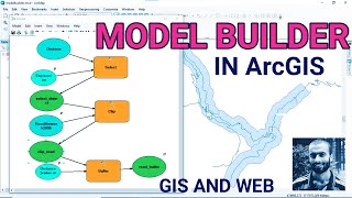
- To use GIS to solve this problem, you can follow these steps:
Data Preparation:
Ensure you have shapefiles for the existing road and the built-up areas.
Make sure the data is in the same coordinate system and projection.
Buffer Analysis:
Use the buffer tool in your GIS software to create a buffer zone around the existing road. This buffer should represent the required 20-meter right-of-way (ROW) for the new road.
Overlay Analysis:
Perform an overlay operation (e.g., intersect) between the buffer and the built-up area shapefiles. This will identify areas within the buffer where the existing built-up areas overlap with the proposed ROW.
Analysis Output:
Examine the output of the overlay analysis to identify the specific areas where there may be conflicts between the new ROW and existing built-up areas.
Decision-Making:
Use the results to make informed decisions about land acquisition, road design modifications, or zoning changes to accommodate the new road design while minimizing conflicts with existing structures.
Visualization:
Create maps and visualizations to communicate the proposed ROW and its impact on the built-up areas to stakeholders.


![Noob To Max With DRAGON REWORK In Blox Fruits [FULL MOVIE]](http://i.ytimg.com/vi/LnBMOinoOvA/mqdefault.jpg)


Thanks bro,pls where can I download the map the you used in this tutorial