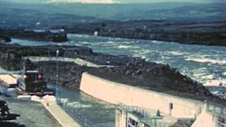
I’ve done some early solo spring paddling off the end of the North jetty and the sandbars extend out quite far. It was incredibly anxious kayaking with waves coming from two directions combined with current running around the intensified pinch point at the jetties distal end. Even after giving the North jetty termination point a wide berth I was amazed to see the sandy sea bed in the deeper troughs. I can understand why the crabbers capsize when they cut in too close. I rolled a few times too but kayaks are a little easier to right. I believe it’s about 2 miles between outer jetties. I’m not sure what depth the sandbars are at in the shipping lanes but there is obviously dredging going on (and I think I know where it put after😝).
Hi @zanelile8192! At the widest point (west) it’s about three miles wide!! Impressive, huh? You can read more about these jetties here: www.nwp.usace.army.mil/Locations/Oregon-Coast/Mouth-of-the-Columbia/


![Seungmin "그렇게, 천천히, 우리(As we are)" | [Stray Kids : SKZ-PLAYER]](http://i.ytimg.com/vi/kAzmhLHePqU/mqdefault.jpg)


5:16
so this area is being sacrificed as the relocated area for the wave energy to disperse ??
1:50 ??? Tell me how they managed to get that huge structure out there and why google maps shows them as huge cut megalithic stones.
I don't think the army corps of engineers could do it today.
That is a LONG jetty!
I hear that both Jettys equal 9 miles!
How far between jetties ? Are their massive sand bars going out an coming in ? Nice video, thanks
I’ve done some early solo spring paddling off the end of the North jetty and the sandbars extend out quite far. It was incredibly anxious kayaking with waves coming from two directions combined with current running around the intensified pinch point at the jetties distal end. Even after giving the North jetty termination point a wide berth I was amazed to see the sandy sea bed in the deeper troughs. I can understand why the crabbers capsize when they cut in too close. I rolled a few times too but kayaks are a little easier to right. I believe it’s about 2 miles between outer jetties. I’m not sure what depth the sandbars are at in the shipping lanes but there is obviously dredging going on (and I think I know where it put after😝).
Hi @zanelile8192! At the widest point (west) it’s about three miles wide!! Impressive, huh? You can read more about these jetties here: www.nwp.usace.army.mil/Locations/Oregon-Coast/Mouth-of-the-Columbia/
Do they need to dredge that big of a river?
I thought the Humboldt Bay jetty was big...this is it's own zip code.
Yes they have to dredge the bar every year. This is one of the most dangerous bars in the world.
Important jetty
We agree!!
They did not film the South jetty. Only the ones on the Washington side.