Thank you so much for this video! Until I found your video I could not get my conversion to work. I was missing was the Geometry AS_XY which was not explained in any of the other guides I found.
Thank you Jamie! I really appreciate that! In fact I am glad it was helpful🙏🙏 By the way if you are interested with water supply and gis please subscribe..
Just a query.Is it required to input pipeline data into EPAnet in northings and eastings or latitude and longitude which is required to calculate heads and calculate the node distances? What is the format required in Epanet soo that it calculates head and distances in pipeline?...
Hello TSHERING welcome! The format that is required to perfom hydraulic modeling in EPANET is UTM (Eastings and Northings)! Actually I have other tutorials that will guide you to import data in EPANET... 1. How to Import data into EPANET: ruclips.net/video/wslkzGGVuoU/видео.html 2. And please visit my channel I have some good EPANET tutorials that may be helpful to you!
@@HydroinformaticsAcademy Many thanks for replying. i tried your excel conversion method.But i am not getting the actual distance between nodes and all distances are shown as 0. Where could i be going wrong?..I got the pipeline kml file from google earth,then used Qgis to get elevations and N,Eastings.But while importing and checking in peanut,i cant get the nodes distances??
@@tsheringtashi1042 If you have your UTM data in Excel then follow the tutorial i gave you and make sure you follow step by step and make sure you downlod the EXCEL TOOL FILE PROVIDED ON THAT TUTORIAL (ruclips.net/video/wslkzGGVuoU/видео.html). If you are not getting distance between nodes then chances are you did not turn "auto-length ON" in EPANET! Let me know what you get! But if that tutorial does not work then use this if you have AutoCAD with Civil 3D (ruclips.net/video/-i_0NsoPM5M/видео.html). And before you import you csv file to AutoCAD Just make sure you close each excel files. Let me know what you get! NB: If you have KML file, to get Northings, Easting and elevation data from it then follow this tutorial: ruclips.net/video/vq8FqIXnDo0/видео.html
Thank you for the video. However, I am getting the same data back with no change in the excel. I read through the comments and have made sure that I select as XY. I am not able to find any relevant UTM coordinate system for entire Europe and if I just take anything else it doesn't work
Hello Himanshu, welcome! I think the issue is in "relevant UTM"... Where did you get your LatLong coordinates? Did you extract them from google earth? If so do you have kml files for your data? And Which QGIS version do you use?
@@HydroinformaticsAcademy Thank you for your response. The issue was with the UTM, once I fixed that, everything worked out. I hope for the success of your channel :)
Trust me there is somewhere you are missing something... especially at the final step when I was setting "XY" and "YX" in QGIS... (myself i had same problem and thats where I was getting stuck)
@@HydroinformaticsAcademy I finally cracked it..i was setting my current CRS at first step instead of using WGS 84. Thank you,i had to watch a million times to realize the error.Hahahaha


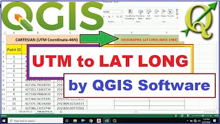


How to convert UTM coordinates to Latitude Longitude: ruclips.net/video/Cz4DutaXusg/видео.html
Thank you for the video
Very well explained! Thanks a lot :)
Thank you🙏
Thank you so much for this video! Until I found your video I could not get my conversion to work. I was missing was the Geometry AS_XY which was not explained in any of the other guides I found.
Thank you Jamie! I really appreciate that! In fact I am glad it was helpful🙏🙏 By the way if you are interested with water supply and gis please subscribe..
Best thank you very much!
Alfred, you are welcome🙏
Great video, thanks
You are welcome Michael, I am glad it was helpful🙏
Just a query.Is it required to input pipeline data into EPAnet in northings and eastings or latitude and longitude which is required to calculate heads and calculate the node distances? What is the format required in Epanet soo that it calculates head and distances in pipeline?...
Hello TSHERING welcome! The format that is required to perfom hydraulic modeling in EPANET is UTM (Eastings and Northings)!
Actually I have other tutorials that will guide you to import data in EPANET...
1. How to Import data into EPANET: ruclips.net/video/wslkzGGVuoU/видео.html
2. And please visit my channel I have some good EPANET tutorials that may be helpful to you!
@@HydroinformaticsAcademy Many thanks for replying. i tried your excel conversion method.But i am not getting the actual distance between nodes and all distances are shown as 0. Where could i be going wrong?..I got the pipeline kml file from google earth,then used Qgis to get elevations and N,Eastings.But while importing and checking in peanut,i cant get the nodes distances??
@@tsheringtashi1042 If you have your UTM data in Excel then follow the tutorial i gave you and make sure you follow step by step and make sure you downlod the EXCEL TOOL FILE PROVIDED ON THAT TUTORIAL (ruclips.net/video/wslkzGGVuoU/видео.html). If you are not getting distance between nodes then chances are you did not turn "auto-length ON" in EPANET! Let me know what you get!
But if that tutorial does not work then use this if you have AutoCAD with Civil 3D (ruclips.net/video/-i_0NsoPM5M/видео.html). And before you import you csv file to AutoCAD Just make sure you close each excel files.
Let me know what you get!
NB: If you have KML file, to get Northings, Easting and elevation data from it then follow this tutorial: ruclips.net/video/vq8FqIXnDo0/видео.html
Thank you for the video. However, I am getting the same data back with no change in the excel. I read through the comments and have made sure that I select as XY. I am not able to find any relevant UTM coordinate system for entire Europe and if I just take anything else it doesn't work
Hello Himanshu, welcome!
I think the issue is in "relevant UTM"...
Where did you get your LatLong coordinates? Did you extract them from google earth? If so do you have kml files for your data?
And Which QGIS version do you use?
@@HydroinformaticsAcademy Thank you for your response. The issue was with the UTM, once I fixed that, everything worked out. I hope for the success of your channel :)
Thank you for watching my tutorials Himanshu and I am glad you managed to solve it!
Have a good day and Good luck with your project!
Sir, there is no UTM option in my qgis.
It should be there, my friend. Please check the projected coordinates and ensure you know your UTM Zone.
@@HydroinformaticsAcademySir, I got it thanks
why my UTM data result is all the same? help me pls
Did you check "XY" and "YX" as I explained when I was producing my results (at the end of that video)?
I don't know why mine is not coverting and i have followed all the steps..it's reproducing the same
Trust me there is somewhere you are missing something... especially at the final step when I was setting "XY" and "YX" in QGIS... (myself i had same problem and thats where I was getting stuck)
@@HydroinformaticsAcademy I finally cracked it..i was setting my current CRS at first step instead of using WGS 84. Thank you,i had to watch a million times to realize the error.Hahahaha
You are welcome🙏
@@sanitationEng Thank you... so much for this comment. I had the exact same issue, and solved it by reading your comment. Thank you Cynthia