Cross Country Planning

HTML-код
- Опубликовано: 7 фев 2014
- Donate to our channel: passfaaexams.com/donate/
Visit: passfaaexams.com/ to see how we can help you put your aviation exams behind you!
This time we are going to tackle all the steps necessary to go on a VFR cross country flight.
All brought to you by www.passfaaexams.com
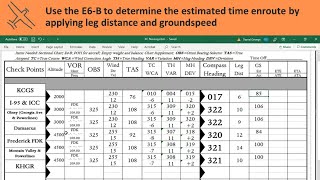
If you need a flight plan log visit the link below
privatewrittentest.com/images/...


Passed PPL checkride and oral with ease. Thanks a lot for all your help.
Congratulations Captain!!! passfaaexams.com/
Thank you so much. I am getting my AGI now as weather in florida is bad so cant fly much. I will recommend your software for everyone. I am getting your software for IFR training as well. I think you are much better than kings and gleim
Mine is tomorrow.
I FINALLY understand how to use the plotter, was killing me. thank you so much
Thank you! Your English is very clear to us foreigners. And not like the other teachers, you don't speak too fast. This helps us understand every points of the video clearly!
Thanks Lucas:) your videos are very helpful. I am planing to get my CPL current after not flying for 10 years, all these videos helps me refresh big time before i spend money on a ground instructor. thanks again.
donnyguns1 Thank you Donny. Before you spend some money with a ground instructor you might wish to take a peak at our courses. In your case I would probably recommend the Private Pilot Check-Ride Prep software as its also an excellent companion for a BFR which is what you will be doing. If you are also IFR rated and are thinking of doing an IPC then you might also want to purchase the Instrument Check-Ride Prep software.
They are available for all devices online at: passfaaexams.com/faa-check-ride-prep-software/
or on iTunes at: itunes.apple.com/us/artist/pts-gs/id552335173
Lucas
Always the best videos, I love your explanations and visuals, your videos are perfect to follow along with as a beginner! Thank you Luca 😁
Thanks... Great schooling...! Gordon.... (one of your students questions referred to surface winds for flight log planning .... He should know that surface winds are reported as "magnetic" while winds aloft are reported as "true"...)
Gian Luca you did it again, thank you so much!
Happy to help!
I'm sure someone has already mentioned it but what you put under Course is your TC, that + WCA is your TH, and that with variation applied is your MH. And that with deviation applied is your CH.
very good. Thanks from Portugal
Well, you could fly from KNUW if you were in an F-18 Growler, because that is NAS Whidbey! Maybe KBVS - Skagit Regional with a clearance per the frequency box for KNUW would be the best choice. Fly around or fly over the airspace if no clearance were granted! I fly this area from both KAWO & KBVS. 😎
Great video gian, can you demonstrate something a little harder, such as an inter-island flight in hawaii where you are over water and there aren't visual cues for check points?
Cheers , very helpful and clearly presented
so helpful! thank you so much!
I really enjoy the great contents you posted
Thank you Sir.
Especially during your climb, your airspeed is never going to be the same as ground speed.
NICE !!!
Great review...
Very good video.
This video is really helpful for beginners but how did you start off your altitude at 3000 feet? Shouldn't you calculate the fuel quantity for the climbout and everything?
Thanks, man really helped me out.
Gottacos
Gottacos
?
Hi, what software are you using that utilizes the navigation plotter?
wow flying is so much fun
Just saying how do you get this charts???
Thank you sir!!!!!
You are welcome. Get the full courses at: passfaaexams.com/
CAUTION: Misinformation at 8 min 20 sec. Variation is not the difference between TC and TH. Other than that, love the video and the effort you put into it.
Agrred. But only that...they say that TC is the course corrected for WCA that is wrong! True course is the desired direction of flight as measured on a chart, clockwise from true north! TH is TC corrected for WCA...MC is the TH corrected for variation and CH is the MH corrected for deviation.
Hi Lucas,
Thank you for the video firstly. I'm a little confused with the intial part of the flight plan towards getting distance for TOC. Is it ok to substitute 90KTS for 90mph,considering 1KT =1.5mph. How did you also get 4.5 minutes? Thanks in advance!
***** For the TOC distance you should refer to you POH. Now if your airspeed indicator shows MPH rather than knots then yes you should convert it but 1.5 is too much 1 KT = 1.15078 so 90 KT = 103.57. Finally to find out the climb time you would also refer to the climb performance of your POH. It will give you time, distance and fuel used.
How many minutes do I have to add if I'm departing to the opposite direction or have to climb in the pattern?
Your POH has data table for climbing to altitude, time, fuel burn.
Very nice and very difficult...
Dear JC. Congratulations. I'd like to know about the tool that, on screen, take distances and course directly over the chart. Can you inform how download or to buy this tool? Many thank for your attention
Dear Mr. Aranha
I am not sure who JC is. In any case the tool you mention is called a plotter and can be bought from any pilot store. just google: "buy an aviation plotter" and you will find plenty.
Lucas
Hello Luca! I have a question about the winds aloft. If I am planning 4500 cruise altitude. There is no FD for 3000 feet and next column is 6000 feet. should I go for 6000 feet numbers?
Guilherme Pereira Yes Mr. Pereira definitely. Do not interpolate between surface winds and 6000 feet as, generally, they will be quite different because of surface friction. Also keep in mind that if the winds at 3,000 feet are not shown it means that the reporting station elevation is at least 1,500 feet MSL and could be as high as 4,449 feet MSL (no winds are forecast within 1,500 feet of the station elevation). Flying at 4,500 feet might put you dangerously close to the ground.
Thank you so much!
Hello Lucas,
Could you please point out a formula with which we can calculate our FUEL ( without e6b )
Karim Hasnawi Simple. Let's say your fuel consumption is 9 GPH (Gallons Per Hour) and your total flight time will be 4 hours and 36 minutes. All you need to do is multiply 9 x 4.6 to get an answer of 41.4 Gallons.
The reason I multiplied 9 (the GPH) times 4.6 is because:
36 minutes is 36/60 of an hour which equals .6. In other words each 6 minutes is .1 of an hour, add to that 4 hours and you have 4.6 hours.
Thank you so much Lucas I really appreciate it; you always answer my questions and subscribers, keep it up i amlooking forward to watching new videos.
How and where did you find your winds for the flight? I know why you chose 3000ft, but where did you find that at?
Dill Robinson Hello Mr. Robinson
To find the winds you need to refer to the Winds and Temperatures aloft forecasts (FD). Any aviation weather site will offer this information. here is a link to one of them:
www.aviationweather.gov/windtemp
Awesome thank you kindly. And thanks for the quick response!
Dill Robinson No Problem Sir.
Our Customer Service is ranked in the top of the industry for good reason!
the plotter numbers don't seem correct to me at 3:20. I see 111, 291, 21, 201. You are reading where the yellow line intersects the numbers on the plotter right?
First leg's readings are actually 111, 291, 21, 201. Therefore, the correct course is 201. However, not a big deviation, only 2 degrees (from 199).
Yet, I'd prefer that the author agree this correction to prevent further confusion.
if the windaloft prediction is at 3 Pm and then at 5 PM but flight is at 4 PM then do we need to interpolate or just use 5 PM winds? Thanks in advance
the 6-hour forecasts are usable from the time they are issued until 3 hours after the valid time. The 12 hour forecasts are usable from -3 to +6 hours of the valid time and 24 hour forecasts are usable from -6 to +6 hours of the valid time. The products are issued 4 times daily. So if the winds were issued at 3 PM (your local time) a 5 PM flight could use either forecast.
Isn't 4.28 minutes 4 minutes and 16 seconds?. you should multiply the decimal by 60 to give you your seconds. This goes for hours also. 4.28 hours = 4 hours and 16. 8 minutes
I understand that the winds aloft for 3000 feet were 030 at 14. My question is, why did you use those winds for the takeoff to the TOC? This always messes me up in trying to fill out a proper flight log. For example, if the winds aloft for my chosen altitude of 6000 feet were 3000 at 20, what winds would I use during the climb phase? Surely they are not 3000 at 20. My next question is that 90 knots you used, were did you get that from? Is that the Vy speed from the POH? If so then it's ok to enter indicated airspeed into the column of true airspeed on the nav log?
The best thing to do is average out the winds but do not use the surface winds.
For example the winds at 3000 are 250 at 12 and at 6000 320 at 15 then average out the winds for the climb at 285 at 13 knots. And yes the 90 knots was just a starting random number. What you need to do is find the true airspeed for a given configuration from the POH and you can use that for the Nav Log.
Gian Luca Noia Thanks for the fast reply. I understand better with the winds now. Now regarding the airspeeds, my POH shows the TAS for a given power setting at a certain pressure alt, which I enter onto the navlog as my TAS.During the climb though, all my POH shows as far as I know is the Vy Vx speeds, which are indicated. So during the climb phase, is it ok to enter the indicated airspeed in the TAS column as my reference ?
bugnut82 Yes you would use Vy or higher for better engine cooling and greater speed (unless you need to clear an obstacle). Entering the indicated is fine as long as you aren't climbing to 40,000 feet and the temperature is way off standard.
Gian Luca Noia Cool thanks again. Sorry to pepper you with a bunch of questions, but I have more. Since you said I can average the winds during the climb phase, that would affect my ground speed. For example, if I am climbing at Vy (75) and I entered that onto my nav log under the TAS column, when trying to get my ground speed, it's ok to use 75 as the TAS even though it's indicated only?
bugnut82 Yes, unless again you are climbing to 40,000 feet and the temperature is way off standard.
By the way you might be interested in purchasing our virtual ground school at:
passfaaexams.com/private-pilot-knowledge-test-prep/
Its a 13 Hour ground school that goes over every concept a Private Pilot needs to be familiar with. Yes its $100 but you will probably save over 2,000 in ground one-on-one with your instructor.
When you tqke the written test. Do they provide you with a plotter. Or do u need to bring one. One test wuestion asked for the time in route. But gave you no distance or heading information to calculate groundspeed. So you would need plotter to find distance and heading. ????
Yes you will need a plotter and a flight computer
Gian Luca Noia they do not provide at the testing center correct?
luke cartwright nope
Gian Luca Noia thank you. Last question about your quizes. This one really bugs me. On density altitiude chart questions. If i use the cx2 and enter the numbers to find density altitude. I get the question wrong. Where as if i use the chart provided. Which is less acurate i get a diffrence answer that is the correct one. Are the answers to the question based off the chart and not the exact number on the cx-2? Because now i am afraid to use the cx2 on my test if it gives me the wrong answers.
how did you do it can you share with me , thank you
3000 ft at 9 degrees give you a true airspeed of 109 kts. Where are you getting 115 from?
CAS and TAS are obtained from the POH
How do we draw a straight line if distance is longer than length of plotter and do we need to use winds aloft for each way point or just one wind aloft from origin of flight is ok? Thanks in advance
You can easily use a yardstick or just any long straight object to trace the line then draw the checkpoints. That done use the plotter to calculate the distances between them. Add them all up to get the total distance.
For the winds you should use at least three stations for a long X-C (more if in a mountainous region).
thanks for quick and very helpful reply
really helpful
top of descent?
Thanks man.🍊🍋🍋🍓🌽🌽🌽🌶️🌶️
I like the accent
where do you get the calibrated airspeed of 110??
CAS and TAS are obtained from the POH
Thanks for your reply. Is CAS IAS?
Calvin Watson CAS or calibrated airspeed is IAS (indicated airspeed) corrected for errors and such in the aircraft's airspeed indicator. There is a table in the performance section of your pilot's operating handbook that gives you the CAS for various IAS and different flap settings.
TAS is CAS corrected for the pressure altitude above sea level and as a rough approximation, TAS is roughly 2% higher for every 1000ft above sea level. So, for example, at 6000ft MSL if you obtain a CAS of 80kts, it will mean a TAS of about 90kts. This is just to explain the theory.
However, as mentioned above, for purposes of flight planning, you can obtain the KTAS from the POH (under "cruise performance"), which is given for various pressure altitudes and temperatures, at a particular engine RPM setting.
For example, I fly a Cessna 152 and if I plan to fly at an altitude of 4000ft and the temperature is 20C above standard (15C), then my POH says at an RPM setting of 2300 (typical cruise for the 152), the TAS will be 95 with a fuel consumption of 4.9 GPH.
why would you climb at 90 knots, shouldn't it be Vy at 74
alhfgsp every plane is different
alhfgsp plus some people use a cruise climb airspeed which is greater than vy
Another reason is for visibility. Being able to see out over the cowl and scanning for possible traffic.
How are you overlaying the plotter???
I don't think I understand the question. The video is fairly clear: align the plotter with the line you drew on the map and then slide the center until it's over either a latitude or longitude line...
How are you getting the plotter to display?
Art Wright Still not sure if you are talking about the software I use to make it all happen or else?
Yes, what software/application?
Well its a combination of Adobe Captivate and Flash. Most of the animations are made in Flash but now I have switched to Adobe Edge Animate as it publishes as HTML5 and thus its viewable on iPad and Android. But for the RUclips Videos I stick to Flash as its much faster and more powerful than Edge Animate.
One error course and true course should be the same number. But overall great video!
i need to make one from bkl to tso and i have no idea how to do it can someone help me
Sure
and flying over a national border sounds kinda sketchy also
block9699 you have no idea about flying close or in Canada..😳
I'm so freaking frustrated. All of this hinges on the wind info. WHERE DO YOU GET THE WIND INFO!!!!
At the time, from the FD (winds and temperatures aloft forecast).
@@GianLucaNoia thanks, big help
Sekiu sounds like /See-Queue/. Sorry, I am a local.
Lost me at around 6:47. Way too advanced for me. I don't know what most of those terms mean. I think I need to find a more basic introduction to all the terms, theory used in this vid. Thanks anyway.
N
Did you really just take 90 knots divide by 60 Mph to get 1.5 miles per minute. Check your units! 1 knot = 1.15 mph. 90 knots = 103.57 which is roughly 1.7 miles per minute. Check your math before publishing this... and that many views.
Ahh, Sir. Maybe you are new at this but 90 knots equals 1.5 NAUTICAL MILES per minute. Maybe you should check your aviation chart and airspeed indicator before posting such a silly comment!
This is the worst video on nav log.