@theubercaste The coriolis effect is small enough to be ignored in flight planning; winds have far more of an impact. Regarding curvature, aircraft altitude is measured by atmospheric pressure and adjusted accordingly throughout the flight (usually automatically on modern passenger jets). As long as this is happening, the plane will naturally follow the Earth's curvature, which is about an 8 inch drop for every mile (though not a drop at all if measured relative to the earth's surface, so plane instrumentation won't show it).
They can also pick you up and drop you. I was walking in the yard last week and next thing I know I was flying inverted in the air and my shoes flew off as it started to rain heavily. I landed on the payment
yes that is correct warm fronts are low pressure and cold fronts are high pressure , air pressure does matter because it effects the wind . cold fronts usually cause severe thunderstorms in the summer and in the winter they usually bring colder weather , warm fronts in the summer usually bring light yet long rain , and in the winter they bring a little warmer weather . If you need more answers on occluded fronts and stationary fronts , ps hope the answers helped>
This makes the strange winds before a thunderstorm that always seem to be coming up from below and exposing the backsides of leaves make sense.. the cold air wedge
All of the comments are from years ago... I had this for class today. My teacher uses obscure old videos XD but they work, and this was a good learning source for me
It's actually supposed to be very cold in any area of my country, but there are a lot of warm fronts which push the cool air and make my country very very warm compared to its average temperature during winter, and it also usually leads to extremely dry and boring weather.
Much effective & precious thn 2 hours.. Thanku very to save us from so called 30 minutes tutior who doesn't explain in 1 hour ,u clearly explain this beautifully in precious 2 minutes,lot of respect from deep heart dear sir❤
I have questions. In the frontal zones are the Temps dropping ? It's like no man's land. For example sw winds ahead of a cold front and nw winds behind it. So would it be west in the cold front zone
My question is why does sometimes the cold front get pushed out of the way and why does it sometimes advance. And why is cold air heavier than warm air?
Just curious... Does anyone know how fast the air will plummet at the leading edge on average? Also what is the max known speeds that it can plummet? In addition, I've only recently learned that there is a different process and shape between the two types of fronts, so... I ask the same questions for a warm front.
But after the cold air has gotten under the warm after the cold front has passed, Is the atmosphere very stable because there is cold air under and warm air on top? Or does the atmosphere get unstable again when the sun heats the ground on top of it being still warm from the warm sector?
And if the warm air from the warm sector is on top of the cold airmass, does it create an inversion layer that limits the possible growth of showers or even storms? Im pulling a lot of conclusions here but I just want to learn :D
it depends that what type of front is occuring if cold front condition then in this precipitation occur with thunderstorm but not so much it may be of short duration.because moisture carrying air does not account for long time while in case of warm front condition will become vice versa
I was thinking the same. But ATPL go more in depth assuming you know the basics of fronts. This would be more at a PPL level. Whole point of the ATPL questions and limited time is a test in it self, testing your ability to make sense and react and decide with limited or obscure information.
Air can only hold a certain amount of water (air holding water = water vapour). When this limit is reached, the water vapour condenses and turns into water droplets, and therefore precipitation occurs. This limit depends on the temperature of the air. Warm air can hold more water than cold air, and therefore has a higher limit. Air is warmer near the ground and colder far away from the ground, and therefore when air rises it cools down. As I already said, warm air has a higher limit than cold air, and therefore as the air cools down (because it is rising), the limit decreases. Water vapour is moisture, and therefore with "the ability to hold moisture" he is referring to the water vapour limit of the air mass.


I learned more in this two and a half minute video than I did in the one hour I spent reading my textbook. Thanks a lot!
Nerd
@@tweektweak1605 shut up idoit
Yeah me too
@Zeb Brannock replying to a comment 2 years ago, whose the real *idoit* here
@@shooz7147 u just dont get the joke idoit
I wish the pilot manuals explained fronts this clearly. Thanks. Simple and to the point.
Damn.. im a private pilot doing commercial piloting rn these fronts brought me here as well haha...
how do the manuals handle the "rotation of the earth, Coriolis, and curvature" when flying?
@theubercaste The coriolis effect is small enough to be ignored in flight planning; winds have far more of an impact. Regarding curvature, aircraft altitude is measured by atmospheric pressure and adjusted accordingly throughout the flight (usually automatically on modern passenger jets). As long as this is happening, the plane will naturally follow the Earth's curvature, which is about an 8 inch drop for every mile (though not a drop at all if measured relative to the earth's surface, so plane instrumentation won't show it).
Oh man i love this century, the ability to create visualizations for better understandings of almost everything. Thank you!
This 2 minute video helped me understand fronts so much easier than any of the hours of lessons for either my private or instrument pilot certificate.
They can also pick you up and drop you. I was walking in the yard last week and next thing I know I was flying inverted in the air and my shoes flew off as it started to rain heavily.
I landed on the payment
Who else is in quarantine watching this video, that was sent to you from your science teacher?
ME 😂
Yeah pretty much
yes that is correct warm fronts are low pressure and cold fronts are high pressure , air pressure does matter because it effects the wind . cold fronts usually cause severe thunderstorms in the summer and in the winter they usually bring colder weather , warm fronts in the summer usually bring light yet long rain , and in the winter they bring a little warmer weather . If you need more answers on occluded fronts and stationary fronts ,
ps hope the answers helped>
this should be taught in all classes regarding this topic. explains in 2 minutes what teachers explain in 30 or so lol.
That simple ! Why do the ATPL texts not explain it like this?
Dude you saved me 1hr of decoding bad notes. ..clear and precise!
This makes the strange winds before a thunderstorm that always seem to be coming up from below and exposing the backsides of leaves make sense.. the cold air wedge
All of the comments are from years ago... I had this for class today. My teacher uses obscure old videos XD but they work, and this was a good learning source for me
Greatest video ever. Thank you this was very helpful. :)
This video from 2011 taught me more than my 2019 textbook thank you
This visual is perfect. Thanks for your help.
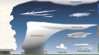
Amazingly simple and effective video. I can now just look up the sky and see what is going on. High clouds, clear sky, low clouds. Damn.
Nice and straight forward video, thanks!
Damn finally understand this ACS topic god damn I didn’t pass my EOC for this
It's actually supposed to be very cold in any area of my country, but there are a lot of warm fronts which push the cool air and make my country very very warm compared to its average temperature during winter, and it also usually leads to extremely dry and boring weather.
Very brief and to the point. Cheers!
Simply explained. I understood more in this video than I did while reading just the 2 paragraphs in my book that literally made no sense to me.
this gave me a lot of info on fronts!
thanks a lot! XD
They are such nice videos that we can do our projects easily without any disturbence.
Thank you so much. This gave me a much better understanding a completely simplified my textbook.
The video is really fantastic for understanding especially that animation !
This was very helpful.
Incredible video!
Wonderfullly explained. Bravo! Thanks.,
thank you very much! Helped me so much! :P
What the difference between these fronts and SHEAR LINE?
Thanks for this video.😊
Great video. Thank you.
Love the video , explained it so clearly
Much effective & precious thn 2 hours.. Thanku very to save us from so called 30 minutes tutior who doesn't explain in 1 hour ,u clearly explain this beautifully in precious 2 minutes,lot of respect from deep heart dear sir❤
Great video. Thanks!!!
Thanks man, saved the day!
great video, thank you.
this video simplifies bunch of books i've read for this matter, thanks for the download..
Hi
What is the software you use? I need one for the school.
Great Video, well explained, Thanks
!
Great Video! Helped with my Science Formative!
To the point.....nice one
I have questions. In the frontal zones are the Temps dropping ? It's like no man's land. For example sw winds ahead of a cold front and nw winds behind it. So would it be west in the cold front zone
Very useful video.
Wow, this is golden, thanks a lot!!!
My question is why does sometimes the cold front get pushed out of the way and why does it sometimes advance. And why is cold air heavier than warm air?
thank you loads really helped!
Thanks for the vid, now i have a much better undersanding!
Awesome
Dr Nitesh
Thanks a lot sir for making this topic simpler.
Superb!!!.Animated Visualization makes complicated Topics understand very easily.Thankyou.
Very helpful, thank you
things clear up thanks
My house is made of tile and it gets really cold under the house. The heat inside i think is making my house really humid
Thank you for making it simple especially your key words like battle front and army .your visualisation skills are amazing.🤟🤟🤟
Very clear thanks !!!
thanks a lot. concise. very informative
THANK YOU!!! This animations along with the weather analogy really helped, THANK YOU!!!!
awesome!! Thank you!
Very cool; what's the name of this interactive?
Just curious...
Does anyone know how fast the air will plummet at the leading edge on average?
Also what is the max known speeds that it can plummet?
In addition, I've only recently learned that there is a different process and shape between the two types of fronts, so...
I ask the same questions for a warm front.
I know it can pick you up and throw you into the air because it happened to me
Best Description
Thanks
Efficient presentation, thanks.
thank you!!
thank you so much, indeed it did
4:30 local time here and this is the story of how I am becoming a pilot...
what application is that pls?
But after the cold air has gotten under the warm after the cold front has passed, Is the atmosphere very stable because there is cold air under and warm air on top? Or does the atmosphere get unstable again when the sun heats the ground on top of it being still warm from the warm sector?
And if the warm air from the warm sector is on top of the cold airmass, does it create an inversion layer that limits the possible growth of showers or even storms? Im pulling a lot of conclusions here but I just want to learn :D
thanks so much!
What sort of precipitaion can be found along boththe warm/cold fronts ??
it depends that what type of front is occuring if cold front condition then in this precipitation occur with thunderstorm but not so much it may be of short duration.because moisture carrying air does not account for long time while in case of warm front condition will become vice versa
and that makes me sad also good vidoe
Thanku so much
It just took 2 mins to clear my doubt.🙂
wait is this the same as low air pressure and high air pressure or does it have nothing to do with air pressure? HELLPPP!
Awesome
great videos but i think you made a mistake in this one - rising and cooling air SHRINKS (not expands) and loses its ability to hold moisture
thx thats really helpful
EXCELLENT visualization!!! God this makes it so easy to understand I wish I saw it years ago......
great exp
I was thinking the same. But ATPL go more in depth assuming you know the basics of fronts. This would be more at a PPL level. Whole point of the ATPL questions and limited time is a test in it self, testing your ability to make sense and react and decide with limited or obscure information.
Thank you 😭😭😭
Me: Looking at the comments Also me:Having to watch it again
Bro so
True
very clear and animations on point! Thanks man, very much appreciated
Thank you
Simple animation but very informative! Thank you.
Great anologies.
Incredibly, awesomely, patiently, massively, gigantically, cool!!
But why do warm fronts cause wind?
very cool
Right on that helped
Thanks a lot
I can't believe two people disliked this video, clearest explanation I've seen yet
Bruh it's 2021 and now it's up to 148 dislikes
good animation
thanks alot!
Thanks man
what do you mean about rising air loses its ability to hold moisture?
Air can only hold a certain amount of water (air holding water = water vapour). When this limit is reached, the water vapour condenses and turns into water droplets, and therefore precipitation occurs. This limit depends on the temperature of the air. Warm air can hold more water than cold air, and therefore has a higher limit. Air is warmer near the ground and colder far away from the ground, and therefore when air rises it cools down. As I already said, warm air has a higher limit than cold air, and therefore as the air cools down (because it is rising), the limit decreases. Water vapour is moisture, and therefore with "the ability to hold moisture" he is referring to the water vapour limit of the air mass.
wery good thank
thanks for the help I'm probably going to get 90-100 present, maybe...I hope
JOSH CANARY ISMT NICE
Thanks loads
Sooooo cool. I love science
NICE
what website is taht?