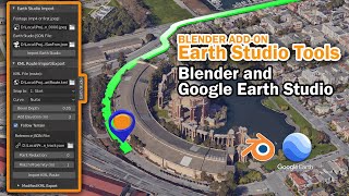
KML in After Effects/Google Earth Studio (FREE script).

HTML-код
- Опубликовано: 7 дек 2020
- Easily import KML paths into After Effect with simple script file. Overlays path for styling with Google Earth Studio projects.
This tutorial also includes masking in Google Earth Studio to interact with 3D buildings (using KML masking technique).
KML importer for After Effect
github.com/imagiscope/AE_GES_KML
Uses:
Adobe After Effects
Google Earth Studio (Web)
Google Earth Pro (Windows)
#GoogleEarth #AfterEffects #kml  Кино
Кино


Oh my god 🙏
Saves my time with the new tutorial ....
Because of you I have an income source online
Thanks You Verymuch 😁
I'm so glad you're able to prosper from the tutorials and script. More to come... Enjoy
@@ImagiscopeTech I will be with you as always for ever ...
Just to let you know that I will be doing many travel maps for my own TV show which is going to be telecast In Sri Lanka.And I will definitely credit you ... Currently I am traveling around and filming for my Show 😊 thanks a Ton
Good luck
Just subscribed. This is simply incredible. You communicate such an apparently complex process so effortlessly. I'm going to give this a try next week.
I don't have kids, but if I did, the first 5 or 6 would all be named after you! Your KML importer script is a game-changer. Great channel, nicely produced pieces... excellent. Thank you.
Thank you for your effort. I´m so hyped for the blender 3D tutorial.
Thank you a lot for the hard work you put in sharing with us your precious knowledge!
Can't wait for the Blender KML exporter tutorial, since I often create maps of trekking routes with significant altitude shifts.
Amen to that. :D
+1 waiting for months now, super-hyped!
So helpful! I was stuck and your video got me passed what was holding me up (KML issue). Thanks!
Terrific Rob, you are a gift to the community. BTW, love the mixing up of routes in Banff with London ;) (Sent from Greece as well!)
I've been working on the 3D KML code this evening ... Was using Santorini as a test area (Oia, for the difficult hills). Greece will definitely be on my list for future renders.
@@ImagiscopeTech Hi Rob - can I ask, what is the nature of the Ae technical limitation on routes exceeding approx 30 km?
A shape layer reaches its limit. Points just start lining up on the limit edge (border)
THANK YOU THANK YOU THANK YOU! Perfect for what I needed to do for a project 👊
Yet another great tutorial. hats off sir. All the best from Greece.
Thanks - Greece is on my mind. I will return, I promise. 🇬🇷
@@ImagiscopeTech if you visit Crete (you should), drop me a line so i can take you for some unique hikes and then we can implement the Blender KML exporter once it's ready, to make some cool stuff 😁😁😁.
wonderful! Very well explained.
Great tutorial helps a lot!
Thank you so much for the great work.🙂🙂🙂
In South Korea, It is already 2:30 AM (KST). Finally, I did it! It worked! Thanks a lot !!
Awesome. I'm glad it works for you.
(2:59 AM MDT)
Thank you so much sir، This tutorial has helped me a lot. 👍
Very good but lots of work, thanks for sharing.
Thank you sooo much !
😃
This is brilliant! :)
THANK YOU VERY MUCH! I will try it ! I LOVE YOU! Haha~
Awesome tutorial! I'd be interested to know if there's some way to dynamically remap the video speed based on the KML data? e.g. correct subject slowing down going up a hill and keep speed consistent throughout footage. Just an idea.
Thank you very much from Russia.
thank you so much :)
Hi! Very nice tutorial! Thanks! Three questions: 1) I can't see the render video and render cloud option, does this method work even rendering a regular jpeg sequence for the "with 3D building" layer? I tried but the script doesn't create the shape layer with the .kml path (it's 12km long) 2) When it comes to bridges what can we use as work around? I was thinking to designing different part of the path on different 3D shape layer at different altitudes and make they look as they were a unique path 3) I've done several 3D routes with your other tutorial (3D magic routes with Google Earth Studio and After Effects); do you have the same problem I'm experiencing when the camera changes angle when the path is drawn on a 3D shape layer? (for instance say you have to draw the 3D route on Central Park and the camera starts from south east, to then rotate and get North POV, and then West POV; the first part of the path drawn on the east side of central park won't be correctly overlaying Central Park alleys when the camera is on the opposite side at the end of the animation; I solved this problem again designing 2 paths letting the first disappear when replaced by path 2). Thanks again and great job!
1) the cloud render is a preview, not available in all regions yet (you can request it via the feedback button)... The renders are MP4 video. 2) for more complex routes, I'd recommend going full 3D, here's the video for Blender ruclips.net/video/J21nqXtFWKw/видео.html (also check out the Car following KML path tutorial for handling bridges)
Thanks for the video! I would like to do the same on a route in the mountains. Could there be a issue with the topography? any help is appreciated!
I also encountered the following error.
"unable to execute script at line 20.XML error in line 36 - Unbound namespace prefix".
I copied and renamed the file to investigate, and the path seemed to be read.
I am Japanese, so the name of the file was also in Japanese.
The cause of the problem may be different from yours, but I hope it will be helpful.
Thanks for the great tutorial!
absolutely awesome! Do you have tutorial by using iMovie instead after effect?
Not for iMovie, but for Blender (free 3D software for Mac and PC). ruclips.net/video/J21nqXtFWKw/видео.html
Enjoying this tutorial but stuck on the script. Any advice? "Unable to execute at line 20. XML error in line 479 - unbound namespace prefix"
Can you use this for the transit Google function or for a plane route?
Great stuff, exactly what I was looking for... but, is it possible, the KML importer is no longer working? I had no effect when importing a KML into AE via this JSX. Meaning: no additional shape layer has been created. Is there a way to manually import KML data into an AE shape layer?
Make sure you have a layer selected in the workspace before importing (i.e. a layer created by the Earth studio import) ... The script needs to know where to make the shape layer. Let me know if that worked.
4:14 3D KML importer for blender. Has this tool/tutorial video been released yet? I'd like to create routes with some altitude change
This is awesome! I have a question to ask, I see there is a video export option from GE Studio.. while I don't see that option in my account.. what can be the reason for this?
Some Google Earth studio features are released at different times to users. Use the feedback button in Earth studio to make a request.
@@ImagiscopeTech thank you :)
was going to ask the same thing. mp4 export in the cloud would be amazing!
does this still work? because when i try to do it, it either doesnt load anything in or i just cant see it
I think this might be what I need. Does anybody know if I can get this script to work as a FPV street view angle?
Excuse me, can remove the inside of the script about 30 km limit??
thank you
KML importer for After Effect script not working any more
Is it possible to make a "Call out card"? I mean let say you pass through Buckhingham palace and then show a photo of Buckhingham palace?
Hi, first of all, thank you for the free script! I ran into an issue, whenever I try to load the KML file to AE using the script, the scale of the KML shape layer doesn't match the map. It is smaller.
How do I fix this?
If your KML has altitude changes you may have to use Blender to create a 3D version. Check out our videos on using Google Earth Studio with Blender
I don't get the shape layer appearing in my comp?
Please tell me, does this script support After Effects CS6?. Thanks again for the hard works.
I suspect it will, however, I haven't tested on that version.
@@ImagiscopeTech Thank you for the prompt reply.
is there a tutorial by adding the route manually in the after effects instead importing the kml file? and animating it at the same time? Thank in advance for the answer :)
I manually make one in this video. ruclips.net/video/_bCgM4wDHZk/видео.html
@@ImagiscopeTech Thank you ill try that out! Please Create more videos like this. :)
@@ImagiscopeTech
What is the advantage of doing it manually?
The KML that made in Google My Maps doesn't work with this script. Only work with KML that made in Google Earth Pro. Sadly enough the route still cannot align with map.
The route starts to change its position in middle of the video, while it's perfectly aligned with the road for few seconds, i don't understand what's the problem.
This is due to altitude changes. If your terrain has changes, you'll want to use the 3D KML technique. View the video here: ruclips.net/video/J21nqXtFWKw/видео.html
We need new video on it
I have tried this many times and can only get it to work with locations which are only a few metres above sea level. When I try it with a route which starts at 44m rising to 47m, the route goes haywire when I composite it in Aftereffects after zeroing out the Transform properties. Is there any way to use the Altitude tab in Google Earth Pro to compensate for this?
To have control over elevation you will need to go 3D ... See ruclips.net/video/J21nqXtFWKw/видео.html
My company is looking to have maps made very similar to what you have made here. Are you interested in a side project?
Hi, so when you say that it's limited to about 30km.. what does that mean? What happens if you want to track a path that's longer? (Say 300km?)
You can use Blender. It doesn't have the same issues. Here's the video. ruclips.net/video/J21nqXtFWKw/видео.html
Hey, I've tried using the script in multiple versions of After Effects (including AE 2020) and a shape layer never gets created and I get no error message. Any ideas as to why the KML wont import? Route is under 30km.
Even i am facin g the same problem. Did you find a solution
Excellent job. Thank you. I'm just having a Problem using AE Version 18 (Build39) Using the KML Script I get the Following error: "unable to execute script at line 20.XML error in line 36 - Unbound namespace prefix"... any help would be much appreciated. Thank you.
I have the same problem - exellent video btw!
i am getting the same problem but at line 74
You have to create a shapes layer, then it will work.
请问这个KML_GES_Import文件放在那个文件夹的?
Had a lot of difficulty with getting the 3D objects I put on the map to stop moving out of sync with the 3D file - it's taken weeks!!. If anyone wants to do really big zoom ins from outer space, I've found it's better to do that as a seperate google earth capture, then create a new capture for closer work.
Also, sometimes the jsx file will have position issues. In GES, export again to overcome jumpy camera position.
Have you used the Blender solution? It's true 3D whereas After Effects is not.
I Have Load the kml file but nothing happaning
Hi. Thanks for the tutorial and the script.
Despite my Google Earth Studio page looks a bit different (No MP4 output and no Cloud Render options), I followed all the instructions, but the script doesn't seems to work. I run it and nothing happens. No error messages and no shapes layer is created. I'm using AE 2020 in a Mac.
I don't know what am I doing wrong...
Cloud rendering is not fully released yet globally. You can request via feedback button on the site. Re: script not working, I've not tested on the Mac OS - that may be the issue.
@@ImagiscopeTech Hi. Thanks for your response. I'd like to know how to code to find and possibly fix that Mac issue. Kudos for your work.
@@paquime I got the same issue Mac AE2020. Ran the script and selected my KML and nothing happened. Does this no support mac build? I suppose I could import on a underpowered pc and save it. Then open on my mac.
This script don't work in aw 2019, error line 41
Great Tutorial! The script is not working for me. Any tips?
I tried it on my work PC(2019 cc After Effects) and Home Mac (2020 cc After Effects.)
Both do the same thing. I run the script, it allows me to select the .kml file and the window disappears but no shape layer is formed.
Select an item in the work area first - lower area of screen (i.e.: the image sequence)
@@ImagiscopeTech Thanks for getting back to me! I tried selecting the image sequence, I tried selecting a null, and I created a shape layer and tried that. Non seemed to work. I’ll do some more trouble shooting and let you know if I come up with anything. I’m sure it’s user error.
@@TheSkyDepot I'm having the same issue, you didn't get it working by chance did you?
@@DavidOakleybloke Sorry, I didn’t.
@@TheSkyDepot no worries
When I render it I get these weird square shaped glitches that appear on a few frames. Any idea why this is?
Are you using mp4 file (video)?
@@ImagiscopeTech Hi, yes I am.
hey guys, I went through the KML_GES_Import.jsx file and noticed they have a disclaimer that there is a 30km route limit due to After Effects. Any way to go around this? Should I just simplify the route and draw it by hand somehow? It doesn't need to be accurate or anything like that.
It's a limit of the After Effects shape layer. You could fiddle with the scale but you will have issues with Earth curvature (if you believe in that sort of stuff 😂). After Effects shape layer is flat. Use the Blender (3D) technique for more accurate and larger (thousands of kms) routes, plus it will curve with the earth.
Here is the link: ruclips.net/video/J21nqXtFWKw/видео.html
thanks so much man, great tutorials by the way!
I'm currently stuck at one point, and can't seem to figure out why my svg overlay moves a lot faster than the rest of the map, like this gyazo.com/890145a50751c823c8beb702de527a4f
Any ideas what I'm doing wrong? I don't care that much about precision/elevation or any of that fancy stuff, just wanna make a simple svg overlay like in one of your earlier vids.
EDIT: The Start and End Track Points that were set in Earth Studio are also moving like that, perhaps it's not related to After Effects.
Have you changed your focal length (camera)?
@@ImagiscopeTech Thank for taking the time to reply man, I really appreciate it.
After fiddling around with this for a while, I've noticed a few things. Creating a new Google Earth Studio project and starting from scratch with a very simple camera animation fixes the issue, and after a bit of time playing with the camera using very basic movements the tracking in AE breaks again, I'm unsure what exactly tho. I just went little by little, re-rendering the project every few keyframes until I ended up with a configuration that seems to work fine.
Seems like some sort of GES bug, very odd.
How does the cloud render work? This option doesn't get displayed on my Google earth Studio account.
The feature may not have been released in your region. Contact Google via the feedback button for more information.
@@ImagiscopeTech Yeah, May 2021 here and I have no mp4 export option in Canada. Image Sequence only. Cheers on the tutorial.
why google didn't just add this features as well in studio. )) make the live easy
$
i cannot run KML, i use macbook
The shape layer is always in the wrong place for me in after effects. Why? Thanks!
Are you linking it to the first trackpoint (to accomodate elevation above sea level)?
@@ImagiscopeTech Helo! Thank you for your reply. But, yes, same problem.
How long is your route?
@@ImagiscopeTech 4,11 km. I can get an email address, I would send a photo?! Thank you!
@ it's in the about tab on our channel page
It's creating shape layer but only a part of it :( maybe it's kml export thing. I'm using online google maps to download kml. UPDATE: same using Google Earth Pro and sometimes it doesn't create any shape at all
Remember, After Effects shape layer cannot go greater than the equivalent of 30km. If you see shape line up on edge, it's too big. Also, make sure you have an object selected in the workspace or it will not produce a shape layer.
@@ImagiscopeTech oh ok, I was trying to get a route about 300km long 🙄 ending up making SVG and trimming patch.
We are coming out with an importer for Blender that will exceed 100's of km and include altitude. It will be full 3D.
There are way too many holes in this tutorial. I followed it to the letter and I experience error after error after error.
Hey Greg. We will be producing another video shortly that will simplify the workflow. Also, I know you're interested in elevation routes, we'll have the 3D in Blender routes coming out in a couple of weeks (testing the software now, free btw).
@@ImagiscopeTech looking forward to it. I use an app call Flyskyhy for flying Paramotors and I it produces a flight path which your method hates 🤣 however I can trace over that line in google earth pro as a work around. Took me 14 hours straight to figure it out. The blender method would be great!
As most kml files are "flat", we use a technique to read terrain altitude and adjust kml route to that. It looks like you'd like it to not use terrain coordinates but to "float" in space. Correct?
Has anyone figured out the - Unable to execute script at line......-Unbound namespace error - error message?
What line number?
i downloaded the file but when i used it, it says 'unable to import file, error at line 74 null is not an object' what to do pls help
Does your JSON file (Google Earth studio project) have a trackpoint?
@@ImagiscopeTech yes
Are you selecting an item in your after effects workspace (I.e.: the image sequence layer) before running the script?
Excuse me, can put the script inside 30 km limit lift??
thank you
Haha. This is a limitation of after effects, not us. You may want to try our blender Add-on. It doesn't have the same limitations
@@ImagiscopeTech Thank you teacher, I see
unable to execute script at line 20.XML error in line 49 - Unbound namespace prefix
please help anyone
More info...
Has anyone experience issues when running the KML importer script? I've got a different error every time :(
BTW thank you, this tutorial is great
Do you know what sort of errors you are getting? What kind of kml file are you using (i.e. single route from Google Earth pro)?
@@ImagiscopeTech Yes, I'm using a single route from google earth, the error goes something like "XML error in line xx (the number is always different)"
It worked now. I re-did the path again in google earth. Not sure what I did different, but it worked. Thanks for the quick reply and the hint !
What is the reason of 30 km area limit?
it's a limitation of Adobe After Effects - if going for larger maps, use the Blender tools as it doesn't have such limitations and curves with the earth
here is the link: ruclips.net/video/J21nqXtFWKw/видео.html
@@ImagiscopeTech, thank you
!
And the Blender video?
It's here. Lots of them.
@@ImagiscopeTech I saw it there, but it's a thick green tube in San Francisco, not a fancy, editable line like in this After Effects video.
sorry your script not working on AE2021 it has unbound namespace prefix error
Thanks - I'll look into it
bookmarked & commenting to follow - didn't know this wasn't compatible with current version. still watching the tutorial as I'm sure not much has changed
KML doesn't run
Where are you creating the kml file (make sure its not KMZ)
What?
you cant do any of this anywhere else but in london, i tried to do it in cdmx and altitude varies from 2400m to 150 m
Try our blender add on. It does altitude really well.
@@ImagiscopeTech ive been trying that for the last 2 days, i cant get to import the kml into blender properly, i might be messing up stuff, but the route is roughly 2000 km and its a nightmare to properly control, ill get back to you when i have more feedback, regardless of my complaints, i must thank you! you are doing an amazing job and these tricks helped me alot, thank you good sir!