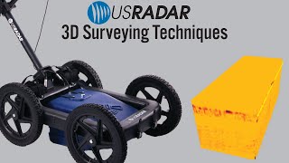
AltoMaxx Ground Penetrating Radar Surveys

HTML-код
- Опубликовано: 28 фев 2022
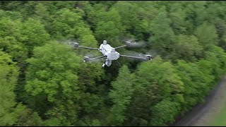
- AltoMaxx unites Ground Penetrating Radar technology with a state-of-the-art drone fleet to collect data on underground objects, buried infrastructure, and soil composition.
GPR is a non-invasive method of data collection used in utility locating, archeology, disaster response, and a myriad of other industries. With a drone-based GPR sensor, AltoMaxx can perform autonomous pre-planned flights, survey traditionally inaccessible terrain, and quickly locate areas of special interest.
AltoMaxx’s experience in acquiring, analyzing, and interpreting GPR data ensures our clients have the critical information they need about their underground assets and infrastructure to make informed decisions and achieve project success.
Find out why the top companies are choosing AltoMaxx for their Ground Penetrating Radar needs at www.altomaxx.com/ground-penet...  Наука
Наука


For agricultural-land clearing operations, can your device detect big boulders that are subsurface? Boulders which are hidden and in about a foot deep underground which is a depth where farm tillage equipment might come in contact with them. Also, a ripper attachment on a bulldozer might collide with the boulders. Ideally, the GPR will have a laser which will paint an outline of the boulders on the ground so that a skid steer with pincer forks can stab into the ground and lift out the boulder. For the soil/bedrock ripper the bulldozer can go around the more deeply buried boulder.
Let’s say I want to hide something underground how can I disguise a cavity from GPR ?
Nice explanation of GPR and very cool seeing UAV GPR in action!
Glad you liked it!
The ideal solution to locating mines and mapping fields! Keep the personal sweeping out of harms way and reveal dimensions etc.
Also may place charges to detonate mines?
Which software do you use for the evaluation
how does it do on hilly terrain? I live on an island that has trees and major hillsides and would love to use this product to find piping with septic systems.
The drone GPR system is equipped with a laser altimeter that allows it to fly in True Terrain Following mode, enabling it to maintain a constant height above the ground, hugging the terrain as it flies over hills and other surface features.
Trees, however, present an obstacle for any GPR system because they reflect the GPR signal and prevent it from penetrating the ground. It is possible to pre-plan your drone GPR flights to avoid wooded areas, or even to fly manually to navigate around trees. However, it is not advisable to conduct drone GPR above the forest canopy. Firstly, flying from such a height would greatly diminish the penetration depth and resolution of the GPR signal. Secondly, in many jurisdictions Ground Penetrating Radar cannot legally be used above a specified altitude (For example, 1 meter is the max GPR altitude in Canada and the US). This height restriction is easily handled with the True Terrain Following mode of the drone GPR system but would typically mean you cannot fly above treetops.
If you have any further questions about the realities of using drone GPR, please don't hesitate to reach out! www.altomaxx.com/contact-us/
Wie viel kostet der preis bitte
Is this system capable of detecting a change in pipe size? say from 12 inch to 10 inch?
The system should be able to detect such a change in exterior pipe dimensions. This would be observed in post-processing as a change in the hyperbola width as the GPR signal reflects off the pipe.
Pretty Badass
How deep on the ground can it detect, like on soil or concrete?
It’s difficult to provide exact figures, as the penetration depth of the GPR signal depends greatly upon the soil conditions of each site. It also depends upon the frequency of the sensor you are using. We have both mid-frequency and low-frequency drone GPR units, but they’re used for very different applications.
If you have a specific project in mind, you can contact us to discuss further! www.altomaxx.com/contact-us/
This is ! 🔥