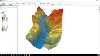
Calculating Volumes With ArcGIS

HTML-код
- Опубликовано: 5 сен 2024
- شرح كيفية حساب حجم الماء في بحيرة باستعمال بيانات من جهاز المحطة الشاملة المحطة الشاملة أو نموذج ارتفاعات رقمية داخل برنامج ArcMap
جهاز المحطة الشاملة الموضح في الفيديو عبارة عن قارب يمكنه رصد الاحداثيات والعمق


ماشاء الله بالتوفيق ياحبيبنا عمر ومزيد من التوفيق ليك يارب
Thank you, very instructif
شكرًا على جهودكم
بس ممكن سؤال انا جديد في الgis وعايز اتعلم . في خطوة انشاء tin يظهر Tool not licensed
شكراً على الشرح الرائع. سوالي هو لماذا لم تقم بتحويل البيانات النقطية مباشرة إلى راستر Raster لماذا حولتها إلى TIN ثم raster؟
شكرا جدا علي الشرح الرائع اخي عمرو
هل من الممكن الحصول علي لينك تحميل بيانات الشرح
شكرا الاخ عمر الى الفديو... اود ان اسال.. فى حالة وجود جبل وتم عمل نقاط ارتفاعات من الموقع تمثل جسم الجبل فى حالة انه القاع ليس افقيا اى مائلا فهل يمكن حساب حجم الجبل فى حالة عدم وجود ارتفاع ثابت لقاع الجبل ؟
شكرا جزيلا
لكن عندي سؤال اكل شخص حاطط unlike شو السبب شو هالنقص بشخصيتك و اخلاقك حتى تحط على فيديو تعليمي قيم unlike ??...
Sir, is there any videos for calculating water spread area and area capacity curve for reservoir siltation???
hi, do you know how I can calculate the cross section area of a river/lake?
dear omer its nice calculating method but you did not mention how you get the points from the beginning, i am new user could you let me help who to start and get the points.
@@gisgate8235 Hi Omar, I am also a beginner and wanted to know if the elevation data is of surface or bottom depths of lake?
I did the same thing but I only get null values for the 3D surface and the volume :( can u help me please.
Nice video, Omar Elhadi!
If my MDE or TIN is set in UTM and meters, in what units will the volume be show? M3, Km3?
Oi Jeanpaulo, as medidas do arcgis são dadas em metros cúbicos
How to get the total station values like that? Thanks
Sir how did you take the points thats into the lake surface
These points are for the bottom, the surface has only one elevation value and you can simply represent it by the elevation of any near point to the surface
can anyone help me, i have some point feature class. I want to create a polygon and calculate the total area size
are that points represent corners of polygon or like that ?
Dear Sir, how could you get the deelt data of the lake.?, thanks
Mr. @@gisgate8235, thanks for your response, Again, my problem, because I have no the depth data or as you say the surveying instrument to get the data of the bottom of the lake.
Dear Mr. Omar Elhadi, thx for a fast response.......