Это видео недоступно.
Сожалеем об этом.
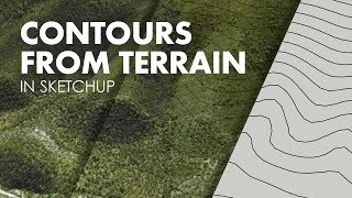
How to Generate Contour Map with Sketchup

HTML-код
- Опубликовано: 17 авг 2024
- In this video I teach how to Generate Contour Map with Sketchup quickly and easily.
Give the video a like if you enjoyed it and don’t forget to subscribe!
****************************
****************************
Watch my previous videos:
How to Conduct Architectural Studies
• How to Architectural V...
Sketchup Modelling Tutorial 2017: Create a Modern Lake House
• Sketchup Building - Ar...
****************************
Subscribe to my channel / @survivingarchitecture
Get socialistic
***************************
Twitter: / surviving_arch
Instagram: / survivingarchitecture
Facebook: / survivingarchitecture
Music:
***************************
Beethoven - Symphony No 3
Become my Patreon: bit.ly/2nS9X8a


We're so close to 1000 sub!! It's so crazy and I am honestly grateful to every single one of you. Therefore, once we reach the 1000 I will do a giveaway for you guys!! Make sure you share the videos so we can get there faster and leave in the comments what would you like to get :)
I literally tried all the elaborated processes by downloading all the plug-ins etc from past 6 hrs that the other youtubers Suggested but I literally gave up on each because some or the other thing was not working out. Now after taking a break I came across your video and I tell you girl i really wish you go and have an amazing time in France someday If you havent already been. Thank you so much. x
This was the easyest method to make contour ,,,... thank you so much
You're most welcome! I'm glad it helped ☺️
What a cute explanation. Makes it so easy. Thank you. I hope you are doing well kid.
I am a second year Architecture student and I found this really useful! Thank you for being straight forward with the video ! ☺️☺️
You're most welcome! Glad it was helpful! 💛
Thanks...delightful listening to you!
Thanks for listening
You have a lovely voice. Thanks for the info.
Thank you for watching and commenting :)
Thank you so much for this tutorial! I'm extremely new to sketchup and it only took me half an hour to make a perfect topo map with your help :)
I am glad it was easy to follow. Thank you for watching!
This plan how do you know different level to another? The different between level to level it may be 0.5 or 1 meter how can I know that?
When you are got the terrain map on SketchUp you need to add planes (rectangles) on each level which is up to you if you want every 1 meter or less. On SketchUp, you then select all and right click on selection go to intersect faces > with the model. And then delete the rectangles and you will have the lines only.
THANK YOU SO MUCH
HELPED IN A RIGHT WAY
Glad you think so!
Its like Magic trick... Its not so good when you know the trick.. amazing. Thank you so much for this❤😁
You're most welcome!
ruclips.net/video/ATz-jbRoFRI/видео.html
This was the most efficient tutorial I've ever seen. Thank youuuu!
Happy to help! ☺️
ruclips.net/video/ATz-jbRoFRI/видео.html native tools
None of video describes like this easily, I really appreciated for the info!
I have contour lines in dwg file (2D), but how to make stair-type contour (3D) in sketchup?
Thank you very much for watching my friend :) You have to import the DWG file within SketchUp this will only work if you have SketchUp Pro if not save it as pdf and trace over the contours in SketchUp. You then need to create faces over each contour and pull them down to your preference.
OMG I LOVE YOU SO MUCH, THANK YOUUU!!!
I love you too, thank you for watching ❤️❤️
oh god you just saved my lifeee
heheh glad to be of help :)
Thank you... really helpful.
Glad it was helpful!
this is really helpful! Love form LA UG1 student :D
Thank you so much! Welcome to the channel ☺️
The simplest way ! Thanks a lot :-)
Glad it helped!
Fantastic! Thank you so much!
You're most welcome!
very helpful,thank youuu
Happy to help! 😊
Happy Eid Mubarak from Indonesia 🙏
And to you too!
This is a life saver
Thank you!
Thankyou I finished my geography hw so quickly
Great job!
Thank you for this informative video
👏
THANK YOU for watching and commenting :)
Hello I want to ask how do you scale the contour map to build 3D model
You'll typically need to know the dimensions of a known area or feature on the map, such as the distance between two points, in order to scale it correctly.
Use the Tape Measure tool (Tools > Tape Measure) to measure the known distance on the contour map. Select the contour map.
Use the Scale tool (Tools > Scale) to resize the contour map based on the measurements you took. Click once to set the starting point, move the mouse to adjust the scale, and click again to confirm.
its so easy when you explained it.
Thank you so much! I'm glad it helped
Thank you so much , this video helped me really .
I have a problem of making building or cars of an area on google earth from 2d to 3d although I checked on all layers , and the same problem happened in sketchup.
I don't know is that some areas don't have enough information to convert their buildings to 3d ?
I'm glad you thought the video is useful. I think so yeah as not all areas have the same information
Very helpful ❤️
Glad you think so!
You are amazing! Thanks a lot for this. Even though I had to google how to copy (because I don't use Sketchup), it was pretty easy and I have my map now. Thank you:)
Glad to know it was helpful and thank you for commenting :)
Beautifully explained, thankyou!
Thank you for your comment :)
Can i draw contours without google map. So i can draw fictional version
THANK YOU
You're welcome 😊
That is great!!! Share more video 🎊🎉🎊🎉🎊
Thank you,, Will do :)
thank you! Really help me =D
Thank you so much! Glad to hear it was helpful
Is it useful for surveyor
superbbb... thanks alot :)
Glad I could help :)
i use crack version and they ask for sign in?? what i do .
Teacher haha don't forget that you promise me to show me how to get topography A to z I meant that where you can it, get or know different level to level and change into the site analysis because topography we add in site analysis learn us step by step. in your site analysis this channel there's topography topography I want to do like that. For example when i go to the site and i see the site has topography but it's hard to me to know different levels. Please learn me that
In this video, you can clearly see that i used the SketchUp plugin which is what you need to use to get it from everywhere in the world. Thank you.
why am i not seeing the location tool on my sketchup
Can u tell me the name of the plugin which you used to make the 2D image into 3d
This confused me too, but you actually don't need a plugin. You can go to file/geo-location then click enable terrain
@@jalensleet5949 I will try that method and I will let u know the result and thank u for your reply🤗
How u achieved 3d view of tht 2d image
Thanks a lot !! this was really Helpful
I'm glad you enjoyed it!!
wow!! thats some sleek skill.....
Thank you! :)
just like u said in your video that if u wanna do the same job with other programs then god have mercy on u cause i just spent past 35 hours learning Arcgis and Qgis softwares . finally i found u.there are no words with i can thank you enough. luving your work!!!!!!!!!
I know what you mean!! I am really glad that I helped you. you don't understand how much it means to me. If I could at least truly help one person then I am extremely happy :)
Muito obrigado!
Ótimo tutorial!
:)
estava pensando em uma alternativa a alguns dias!
Happy it helped!
Thank you for taking the time to do this! 👍🏻
thank YOU for taking the time to watch and comment! :)
i havent worked with sketchup and i lost it after 1:20, God I need this so bad, please help.
Hi , which university are you in Uk ?
Hi I'm in Wolverhampton University
I frequently import GE terrain data into Sketchup using small close up sections (tiles). Is there a way to line up the tile edges of multiple imported GE terrain swatches? I have been doing it by eye, and the overlaps have made it difficult to get elevation/ topography lines to match up. Thanks in advance
Wow👏🏻👏🏻👏🏻
Thank you very much :)
lovely voice thank for the help means a lot
Thank you so much!
can u tell me how many hours u spent not Intersection with Model
What
Surviving Architecture how many hours u finish waiting for intersect face with model
Few minutes or less not hours
@@SurvivingArchitecture i need a big Topography so i import 70 pieces from location. when i intersect face it took me so long from it
Can you switch to a different computer with better specs temporarily? Maybe divide the plan into small sections?
I guess its love from the first video
Hehhe thank you!
Let me know if you need any specific videos!
I haven't watched all ur videos because i have a final to submit on Friday(lol) and i need to generate an tomography map and all I know is Autocad so when u talked about every single step i know how to make that map even though it was my first time working with sketch up. So thanks to you
I wish you all the best!
@@SurvivingArchitecture i would like to have ur comments on it before submitting,so if i can have ur email if u like. (even if you won't give me ur email I will not unsubscribe or dislike the video u have my word😜)
Hey Master!! I have a question. My topography is soooo mild (almost flat) that the lowest point (assume 0meter) till the highest point is only 2meters! So in terms of professionalism, do I still need to show topography for this? If I really need to, is 500mm per layer good?
Hey student lol, im currently working on a project which has a similar flat site, but there is always a topography and you always need to show contours, I think that if you make it 500mm it would be good but try with 250MM as then you can have 8 contours. Hope this helps :) Thank you for watching
Surviving Architecture thank u so much for replying!! So when I denotes the height of topography, do I put 2000 on the highest point and 0 on the lowest?
Surviving Architecture also, to add on, did u show ur topography the way u did above as well in this video?
Your welcome my friend, you just need to create a rectangle that covers the full map and duplicate it 250mm above until it hits the height point and then down until the lowest, all you need to do is pick the area and then click the button which is shown on the video and it will turn it into a 3d map and then follow the rest of the options its very clear and simple. :)
Just last question too, is this the only method to get topography Information for a place? Other than digimap is there other way? Cadmapper I tried but they don’t show contour topography when the topography is too Low like mine. It shows as flat.
Thanks
I would like to ask please if you have any sketchup version which is free please share it to my email. Thanks