This worked well for my contour lines on my tract map. But is there an easy way to label the elevations on the lines? I am importing this data into layout.
how do you know when the faces are intersected. When I intersect with faces all the rectangles got black and grey. Do the rectangle get blue again after intersecting with faces? I have 27 intersections.
Hi. I'm using SU 2022. At 4:07 you select all. Do you include the terrain? I've tried both ways. Following that you ctr l-X. In my case, I lose everything. Any ideas? Thanks, good videos.
Sir when I import directly AutoCAD contour file In SketchUp then show a single line What is the problem of this ? Please respond ASAP because it's urgent Note : import file in which contour is not a existing contour, we are modify it.
Hi lovely, I hope you are well. Any chance you can do a video how to prepare contours file for laser cutting starting from importing digimap or google earth into CAD? How to prepare contours laser cut file from scratch? We couldn't find any videos on you tube. Also laser cut site model. I look forward to watch more of your videos soon. Have a great day:)
nice channel bro , i have a request , did you saw the poster images of skp 2017 and 2018? can you do a tutorial of how can you export images like'em , thanks, keep hacking


What are your thoughts on Sketchup moving the geolocation feature to pro-only?
Yeah, fucking great, i can solve my design problems with ease now
How to get the pro version
YOU LIFE SAVER YOU HAVE LITERALLY SAVED MY ENTIRE PROJECT THANK YOU THANK YOU THANK YOU!!
I've been using SketchUp for 6 years and I just learned more from this video than I have in like the past 4 years of school
But still able to explain each stage in a basic manner. Honestly thanks man!
Thank you so much this save my life and my time !!
Great Video, thanks very much, I've been searching youtube for this exact tutorial.
Dang.. been looking for this for so long ..thanks man!
That was so helpful! I just started using soft and was so overwheld!
THIS IS GOLD.
THANKS IT 'S VERY HELPFUL FOR ME
Thanks man you saved me so much work
This was exactly what I wanted! Thank you!
Great simple summary - thanks for sharing
This worked well for my contour lines on my tract map. But is there an easy way to label the elevations on the lines? I am importing this data into layout.
Thanks a million, helped me heaps appreciate you sharing cheers 👍🏼
Hello, how do you scale the created contours to match the architectural drawing? Thanks
Thanks much ! Just a question when I try choosing by area just to push pull up to heights, it's all selected what can be the reason ?
how do you know when the faces are intersected. When I intersect with faces all the rectangles got black and grey. Do the rectangle get blue again after intersecting with faces? I have 27 intersections.
thank you! this video helps a lot
thanks for sharing
Thanks a lot! It was very helpful!!
we couldn't do that on trial VS right? really amazing!
Great video. More helpful than my lecturers 🥴
thank u so much!
Hi. I'm using SU 2022. At 4:07 you select all. Do you include the terrain? I've tried both ways. Following that you ctr l-X. In my case, I lose everything. Any ideas? Thanks, good videos.
I need to sign in first, but I don't have a license, my sketch up is only crack version, I m just a student, what should I do?
Brilliant !
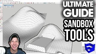
Great explanation. But what about having contours and wanting to make a terrain model?
You could use the Sand Box tools!
Sir when I import directly AutoCAD contour file In SketchUp then show a single line
What is the problem of this ?
Please respond ASAP because it's urgent
Note : import file in which contour is not a existing contour, we are modify it.
thank you!
Thanks, that was helpful :)
Hi lovely, I hope you are well. Any chance you can do a video how to prepare contours file for laser cutting starting from importing digimap or google earth into CAD? How to prepare contours laser cut file from scratch? We couldn't find any videos on you tube. Also laser cut site model. I look forward to watch more of your videos soon. Have a great day:)
whenever i do this all my contours are really jagged rectangular lines with no smoothness whatsoever, what am i missing ?
Is there a way to add contour elevation numbers !???
I have to do the 1/500 scale map of an area how do we adjust the scale of the area we chose?
I have a 20 acre field that I will measure with a transit on a 50 ft grid , how do I convert that to a topographical map ?
How accurate this data is?
I can feel you bro
Note to futire self: This always works awesomely.
The multiply function did not work for me
nice channel bro , i have a request , did you saw the poster images of skp 2017 and 2018? can you do a tutorial of how can you export images like'em , thanks, keep hacking
something like this? www.sketchup.com/sites/www.sketchup.com/files/2018/2018imagery_homehero.jpg
yes exactly
Too fast. I’m here because I need to see the tools and understand the directions
Ikr. Let's use the multiply......hold it, what?
I'm gonna group these up (blur of commands)....
They gotta make money somehow. Since there’s a student price for Pro, I don’t mind so much.
my contour lines are sharp. any ideas on how to fix it?
jhakdfjk 4:10
problem solver
How annoying is your voice and breathing on the mic. I had to stop it. You're too close to the mic!