How to download SRTM DEM image from USGS
US
Войти
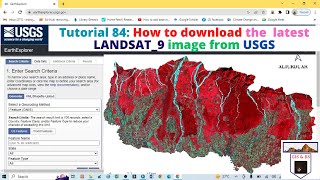
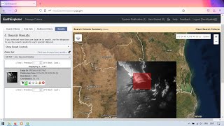
How to download the latest LANDSAT 9 image from USGS
8:34
Downloading Landsat 8 images from USGS EarthExplorer
8:27
Downloading 30m SRTM DEM data from USGS EarthExplorer
10:09
Testing Crazy Catnip Products!
08:46
Watching a Rocket Launch at SpaceX with Elon Musk!
11:40
I Built a SECRET Soccer Field in My Room
27:11
How to download SRTM DEM image from USGS
RS and GIS with Dr. Manoj
Подписаться
12 тыс.
Скачать
Готовим ссылку...
Просмотров 14 тыс.
0
0
Добавить в
Мой плейлист
Посмотреть позже
Поделиться
Поделиться
HTML-код
Размер видео:
1280 X 720
853 X 480
640 X 360
Показать панель управления
Автовоспроизведение
Автоповтор
Опубликовано: 28 ноя 2024
Комментарии • 3
Следующие
Автовоспроизведение
8:34
How to download the latest LANDSAT 9 image from USGS
RS and GIS with Dr. Manoj
Просмотров 4,9 тыс.
8:27
Downloading Landsat 8 images from USGS EarthExplorer
Leonardo Uieda
Просмотров 60 тыс.
10:09
Downloading 30m SRTM DEM data from USGS EarthExplorer
Terra Spatial
Просмотров 15 тыс.
08:46
Testing Crazy Catnip Products!
Half-Asleep Chris
Просмотров 417 тыс.
11:40
Watching a Rocket Launch at SpaceX with Elon Musk!
Kai Trump
Просмотров 3,6 млн
27:11
I Built a SECRET Soccer Field in My Room
The Royalty Family
Просмотров 4,3 млн
01:31
Bishop T.D. Jakes suffers health incident after delivering sermon
CBS TEXAS
Просмотров 346 тыс.
8:02
How to Download ASTER Images for Free from USGS - Step by Step Guide
RS & GIS
Просмотров 6 тыс.
28:15
Slope, Hillshade, Aspect, curvature & elevation map From DEM in ArcGIS
GIS with Raja Usama
Просмотров 14 тыс.
14:57
Download DEM/Elevation, Slope, Roughness, Aspect Map in just One Click
GIS & RS Solution
Просмотров 69 тыс.
11:57
Digital elevation model | DEM | DSM | DTM | What is Digital elevation model
Geousman101
Просмотров 27 тыс.
11:19
Downloading Elevation Data from NASA EarthData
GeoDelta Labs
Просмотров 5 тыс.
14:37
Downloading satellite data from USGS websites
GIS for Beginners
Просмотров 52 тыс.
11:22
Let's Fix The United States' Awful Borders
Geography By Geoff
Просмотров 741 тыс.
28:39
Volume Calculations using QGIS
GeoDelta Labs
Просмотров 14 тыс.
5:27
Download SRTM 30m Digital Elevation Models for Free
CATALYST. Earth
Просмотров 147 тыс.
00:55
Зловещий способ избавиться от детей в Stardew Valley #булджать #игры #stardewvalley #дети #мистика
БУЛДЖАТь
Просмотров 251 тыс.
21:16
ШИН СОНИК НЕ МОНСТР!
BRUNO
Просмотров 409 тыс.
00:38
Lamborghini vs Smoke 😱
Topper Guild
Просмотров 18 млн
00:17
Moment Georgia's election chief is doused in PAINT
Daily Mail
Просмотров 2,6 млн
58:18
Вопрос Ребром - Люся Чеботина
GAZ LIVE
Просмотров 500 тыс.
1:46:02
Да будет LED! Балацко унижен, Олег страдает, Толя счастлив!
Команда АП
Просмотров 711 тыс.
1:04:39
3 Дня как Бомж! Масленников, Сабина, Даник живут на помойке
Дима Масленников
Просмотров 3,1 млн
00:25
Rabbit and child almost poured water on the disabled person#Short #Officer Rabbit #angel
兔子警官
Просмотров 7 млн