Wow big fan. I feel as a new licensed Drone pilot that if I don’t offer this in my business that I’ll be so behind the eight ball. I don’t want to just take pictures of Realestate I want to go after big clients.... so thank you so much for all your info, it’s so nice to see that people aren’t afraid to share ......because I’ll never be any threat to you! Thanks NP , Naples FL.
Nate Dawg, tell Warren G what's up for me. lol sorry, I had to say it. You will never be a threat to me because competition is good for us all. I work with a couple of my local competitors from time to time sharing resources. Thanks for watching. I agree with you 100%. Just taking real estate pictures won't cut it for most people. Mapping and inspections are higher paying. A smart entrepreneur by the name of Patrick Lee told me, "If you go after the big clients, they pay more, complain less, which allows you to do fewer jobs." He went on to explain that it's a general statement and followed up with more sound advice, but it so true. I have not done a small job in a long time. But I still work 80hours a week. haha DAMN you, Patrick Lee!
Hey Warren says sup dude! Naw thank you so much for your advice and farther more if you ever need anything down in this neck of woods please feel free to look me up. natelpate@gmail.com ! Yes my last name is Pate. Thanks so much again NP Naples, FL.
Using Pix4D Mapper, I have on occasion had it not allow me to only pic the GCP in a single photo. Then, when I continue, the ortho photo comes into CAD in the wrond position!! n my opinion, Pix4D makes the best orthos but have had this trouble I mentioned. Any ideas?
I have had issues with Pix4D that were caused by bugs in their software. If it is not a but that they have to fix then you can close the project and reboot the computer. After that, it should work.
What would be your recommendation for increasing my relative accuracy? I keep running into issues such as my terrain appearing to be every so slightly slanted, such as a 8-10 foot elevation change across a distance of 500ft, for example. Just trying to perform some basic volume measurements so I don't need survey-grade absolute accuracy. Should troubleshooting this issue start with mission planning settings changes or is this something that I should be correcting with tie-points later?
@@irbChad Two things come to mind. GSD is the first. As the land moves up or down in elevation the drone should too. You want the drone the same distance from the ground for every image. The second thing that would help is ground control. If you have GCPs the GSD-ground sampling distance stuff is not as important. How high are you flying?
@@GM6DroneMapping Interesting, I'm not sure that I even knew it was possible to have the drone change its elevation with the terrain. We have been flying missions at 150ft
@@GM6DroneMapping support.pix4d.com/hc/en-us/community/posts/360043373371-Increasing-Relative-Altitude-Accuracy I also have more info on my issue on this post
Excellent video. I am new to drone mapping and am about to take my second Pix4D course. My wife has her MS in GIS and I am excited to be learning. Thank you for the information. Mind if I ask what you consider the minimum equipment requirements to collect accurate GCP data?
Bruce, sorry for the delay. Sometimes I don't get my notifications. I would say the minimum would be Emlid Reach RS. You would need two or you can get Reach RS and an Emlid M+ which would go on the aircraft. Now the easiest way to do it is either contract a surveyor per job or AeroPoints. BTW your wives background will be extremely important. You can't do this job without GIS. You are very fortunate.
Thanks a lot for the video series. I saw you on Ready Set Drone and have been sharing your series as a resource in my remote sensing class. Do you plan on doing any other series?
+Jared Taylor Thank ypu, I really appreciate that. At the moment we are seriously discussing a series on how we built our company. I think it will be titled "Building a business from broke" Ive had more questions about business than mapping. Speaking of Ready Set Drone, Kelly is an awesome guy and I really owe him for encouraging and helping me start this business.
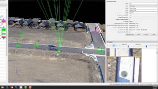
Hi. After inserting the GCPs You have to reprocess step one in order for the currection to take place. You will see that you cant see the quality report after the optimization step because it's not right anymore.
Not sure if you guys cares but if you're stoned like me during the covid times you can stream pretty much all the new series on instaflixxer. Have been streaming with my gf recently xD
Sam Cook Thanks for asking, that is a very good question. I used a surveyor with a base station and GPS rover. We walked the property and put stakes in the ground. I know that is not very helpful but its the short answer. Would it help, and do you think others would like to see a short video explaining the process? I have thought about doing a video with the guy I work with.
Thanks for the response. Personally, I have experience on the surveying side of things, but I'm more curious about the obvious benefits of using gcp's in pix4d compared to programs like drone deploy who don't seem to emphasize the use of gcp's as much and the relationship between global and local positioning. Just my two cents, but people may like some clarity on what GCP's are and how they're measured.
Sam Cook Ill try not to attack DD to bad but its good for business to downplay the need for GCP's. If anyone can map with a drone and pay a service to process the pics then more people will pay for the service because they may not understand that any software or service is only as accurate as the data you give it. The exif file only gets you close. The GCP gets you spot on.
Sam Cook The ground control points are there for more than getting it on a coordinate system vs a local coordinate system. It's to add accuracy, especially elevations. Without accurate ground control points, the orthographic image, contours etc are not design quality. You'll just have a pretty picture without accuracy. I've seen people do volume calculations without using ground control points, I hope they have good liability insurance.
I really like this video. While watching, your GCP's seemed very high before you re-optimized. I've tried using GCP's with a Trimble Geo XT, but they are always around 30m too high. Is this normal, or am I missing a step somewhere? Do you have any suggestions?
Yes it is very typical for them to be high. The drones gps is cheap consumer grade GPS. I'm guessing you missed a step, which is easy to do. I still mess up all the time. If you want to email me i can try to walk you through it. If you can tell me the steps you did it may help. guardmy6@gmail.com
Absolutely fantastic video, although I'm a bit curious, if the client's GCPs are done with poles, would it have been measured from the top of the pole or the bottom? Thanks.
Avhinav Mainali It's usually at least several hundred to a few thousand. It depends how big the project it. You need lots of overlap, the software needs this so it can pick similar points from different pictures.
i am a drone pilot nowadays i am trying to learn about drone photogrametry processing, mostly while doing processing in a software like pix4d i have not getting good accuracy i am getting 7m error to 20 m error. i am doing processing for more than 5 or 6sq.km area i need accuracy of x,y,z within 20cm for that what software i have to use, i have searched a lot mostly the information which i got is i have to do some step manually in some other softwares before processing in order to improve the accuracy likewise its showing if it is true then what are all the softwares how to handle it.


![Felix "Unfair" | [Stray Kids : SKZ-PLAYER]](http://i.ytimg.com/vi/Oswujxm2Ag0/mqdefault.jpg)

Wow big fan. I feel as a new licensed Drone pilot that if I don’t offer this in my business that I’ll be so behind the eight ball. I don’t want to just take pictures of Realestate I want to go after big clients.... so thank you so much for all your info, it’s so nice to see that people aren’t afraid to share ......because I’ll never be any threat to you! Thanks NP , Naples FL.
Nate Dawg, tell Warren G what's up for me. lol sorry, I had to say it. You will never be a threat to me because competition is good for us all. I work with a couple of my local competitors from time to time sharing resources.
Thanks for watching. I agree with you 100%. Just taking real estate pictures won't cut it for most people. Mapping and inspections are higher paying. A smart entrepreneur by the name of Patrick Lee told me, "If you go after the big clients, they pay more, complain less, which allows you to do fewer jobs." He went on to explain that it's a general statement and followed up with more sound advice, but it so true. I have not done a small job in a long time. But I still work 80hours a week. haha DAMN you, Patrick Lee!
Hey Warren says sup dude! Naw thank you so much for your advice and farther more if you ever need anything down in this neck of woods please feel free to look me up. natelpate@gmail.com ! Yes my last name is Pate. Thanks so much again NP Naples, FL.
Thanks Nate. I will
Using Pix4D Mapper, I have on occasion had it not allow me to only pic the GCP in a single photo. Then, when I continue, the ortho photo comes into CAD in the wrond position!! n my opinion, Pix4D makes the best orthos but have had this trouble I mentioned. Any ideas?
I have had issues with Pix4D that were caused by bugs in their software. If it is not a but that they have to fix then you can close the project and reboot the computer. After that, it should work.
What is the minimum processor you would recommend?
That
Lee
@Lee Bowen I would recommend an 8 core 16 thread as the minimum. Depending on the workloads you may not need more anyway.
One question, isnt it enough you work on pix4d , what is QGIS , whats the point of it?
You can find my email in the about section on my channel. shoot me a message if you like, I'll try yo help you on the guyed wire tower.
@@GM6DroneMapping Thanks man!! I've sent an email!
What would be your recommendation for increasing my relative accuracy? I keep running into issues such as my terrain appearing to be every so slightly slanted, such as a 8-10 foot elevation change across a distance of 500ft, for example. Just trying to perform some basic volume measurements so I don't need survey-grade absolute accuracy.
Should troubleshooting this issue start with mission planning settings changes or is this something that I should be correcting with tie-points later?
What drone are you using?
@@GM6DroneMappingPhantom 4
@@irbChad Two things come to mind. GSD is the first. As the land moves up or down in elevation the drone should too. You want the drone the same distance from the ground for every image. The second thing that would help is ground control. If you have GCPs the GSD-ground sampling distance stuff is not as important. How high are you flying?
@@GM6DroneMapping Interesting, I'm not sure that I even knew it was possible to have the drone change its elevation with the terrain. We have been flying missions at 150ft
@@GM6DroneMapping support.pix4d.com/hc/en-us/community/posts/360043373371-Increasing-Relative-Altitude-Accuracy I also have more info on my issue on this post
Excellent job
Thank you Luiz
Excellent video. I am new to drone mapping and am about to take my second Pix4D course. My wife has her MS in GIS and I am excited to be learning. Thank you for the information. Mind if I ask what you consider the minimum equipment requirements to collect accurate GCP data?
Bruce, sorry for the delay. Sometimes I don't get my notifications. I would say the minimum would be Emlid Reach RS. You would need two or you can get Reach RS and an Emlid M+ which would go on the aircraft. Now the easiest way to do it is either contract a surveyor per job or AeroPoints. BTW your wives background will be extremely important. You can't do this job without GIS. You are very fortunate.
Thanks a lot for the video series. I saw you on Ready Set Drone and have been sharing your series as a resource in my remote sensing class. Do you plan on doing any other series?
+Jared Taylor Thank ypu, I really appreciate that. At the moment we are seriously discussing a series on how we built our company. I think it will be titled "Building a business from broke" Ive had more questions about business than mapping.
Speaking of Ready Set Drone, Kelly is an awesome guy and I really owe him for encouraging and helping me start this business.
Hi. After inserting the GCPs You have to reprocess step one in order for the currection to take place. You will see that you cant see the quality report after the optimization step because it's not right anymore.
This was great help!
Not sure if you guys cares but if you're stoned like me during the covid times you can stream pretty much all the new series on instaflixxer. Have been streaming with my gf recently xD
@Ronin Alden Yea, I have been watching on InstaFlixxer for since november myself :)
Wht drone u used?
That project was in 2017 so I think we used a P3P, Mavic Pro, and a P4P.
i need a stand alone or desktop processing system. So which software do you suggest for this purpose?
+ahsan bukhari Well I would suggest the software I used in the video, Pix4D
What about the actual process of measuring the GCP's and what equipment do you use?
Sam Cook Thanks for asking, that is a very good question. I used a surveyor with a base station and GPS rover. We walked the property and put stakes in the ground. I know that is not very helpful but its the short answer. Would it help, and do you think others would like to see a short video explaining the process? I have thought about doing a video with the guy I work with.
Thanks for the response. Personally, I have experience on the surveying side of things, but I'm more curious about the obvious benefits of using gcp's in pix4d compared to programs like drone deploy who don't seem to emphasize the use of gcp's as much and the relationship between global and local positioning. Just my two cents, but people may like some clarity on what GCP's are and how they're measured.
Sam Cook Ill try not to attack DD to bad but its good for business to downplay the need for GCP's. If anyone can map with a drone and pay a service to process the pics then more people will pay for the service because they may not understand that any software or service is only as accurate as the data you give it. The exif file only gets you close. The GCP gets you spot on.
Agreed. Curious about your thoughts on DJI and DD partnering with the out-of-the-box "survey and mapping" package, if you're familiar with it?
Sam Cook
The ground control points are there for more than getting it on a coordinate system vs a local coordinate system. It's to add accuracy, especially elevations. Without accurate ground control points, the orthographic image, contours etc are not design quality. You'll just have a pretty picture without accuracy. I've seen people do volume calculations without using ground control points, I hope they have good liability insurance.
I really like this video. While watching, your GCP's seemed very high before you re-optimized. I've tried using GCP's with a Trimble Geo XT, but they are always around 30m too high. Is this normal, or am I missing a step somewhere? Do you have any suggestions?
Yes it is very typical for them to be high. The drones gps is cheap consumer grade GPS. I'm guessing you missed a step, which is easy to do. I still mess up all the time. If you want to email me i can try to walk you through it. If you can tell me the steps you did it may help. guardmy6@gmail.com
Absolutely fantastic video, although I'm a bit curious, if the client's GCPs are done with poles, would it have been measured from the top of the pole or the bottom? Thanks.
2987ms thank you. The points were measure from the bottom. A long metal nail/stake was placed in the ground for the GCP
GM6, Drone/ UAV Mapping Thank you very much.
The wooden stake was just placed there to mark the area so you could find the ground control point later.
Verry helpful, Thanks a lot.
Thanks, Glad you liked it. I have another good one coming out Friday or Saturday.
How many images did you took for creating the map? I am new to these so it would be very helpful
Avhinav Mainali
It's usually at least several hundred to a few thousand. It depends how big the project it. You need lots of overlap, the software needs this so it can pick similar points from different pictures.
+Avhinav Mainali sorry for the delayed reply. It takes between 500-600 images and about 4 hours to process
+Ty Brady thank you Ty. for some reason I have not been getting these messages.
i am a drone pilot nowadays i am trying to learn about drone photogrametry processing, mostly while doing processing in a software like pix4d i have not getting good accuracy i am getting 7m error to 20 m error.
i am doing processing for more than 5 or 6sq.km area i need accuracy of x,y,z within 20cm for that what software i have to use, i have searched a lot mostly the information which i got is i have to do some step manually in some other softwares before processing in order to improve the accuracy likewise its showing if it is true then what are all the softwares how to handle it.
What drone are you using? One software program can be used for your mapping to be accurate
Great job, thank you.
+Scott W thank YOU for watching. I have some really good stuff coming up with Emlid and Propeller
thanks for sharing...
the "a" in raster sounds like the one in apple.