usually you have a land surveyor observe established ground control points with an RTK/GPS unit and they'll send you the X,Y,Z of those ground control points they established for you and it will be in a CSV or TXT file, then that's when you import into PIX4D. Hope this helps.
I have question You have custom points and you to point them 10 times each but the question Where you get their x y z information before you paste it in PIX4D?
usually you have a land surveyor observe established ground control points with an RTK/GPS unit and they'll send you the X,Y,Z of those ground control points they established for you and it will be in a CSV or TXT file, then that's when you import into PIX4D. Hope this helps.


you missed a very important instruction on how you created the GCP file. That would have helped a lot of people out
usually you have a land surveyor observe established ground control points with an RTK/GPS unit and they'll send you the X,Y,Z of those ground control points they established for you and it will be in a CSV or TXT file, then that's when you import into PIX4D. Hope this helps.
My question is why do you choose to make some check points and some GCP's, what made you decide to do that? That could be something important maybe?
Exactly, I had the same doubts.
to have more precision on the mapping!
I have question
You have custom points and you to point them 10 times each but the question
Where you get their x y z information before you paste it in PIX4D?
usually you have a land surveyor observe established ground control points with an RTK/GPS unit and they'll send you the X,Y,Z of those ground control points they established for you and it will be in a CSV or TXT file, then that's when you import into PIX4D. Hope this helps.
When someone refers to the map accuracy, say 2 cm accuracy, that means that for instance in Pix4d, the GCP RMS error is 2 cm?
how to fix error e0015? when I input GCP csv. wrong format. I follow procedure. please solution
Fix the format. Use four columns. GcpName,x,y,z
Example: Point1,32156.14,13462.12,123.22
@@cezarywozniak6778 ok I fix it. Thx. now works
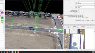
How does pix4d know your flight path and where you took the photos?
Based on GPS tag of each image, time of each image and common features between images
Ah, so the images necessarily need geo tags?
It is possible to align images without geotags but it will process much slower and the project can be misaligned and not accurate
Carlos Carrillo