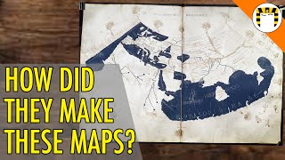
How Old Maps Got Things Wrong

HTML-код
- Опубликовано: 23 июн 2022
- ▶ Follow me on Twitter: / gkonyoutube
▶ In this video I talk about old maps which depicted parts of the world incorrectly.
▶ Become a member on Patreon & get exclusive content! / generalknowledge
▶ Join the Discord Server: / discord
▶ Business Contact: gilfamc@gmail.com
▶ Thanks for watching, remember to subscribe to catch future videos!


*Do you think Australia should try building artificial lakes and rivers to make their desert lands inhabitable?*
As an Australian, I would say that it’s and excellent idea, and would significantly boost the economy, and make the kangaroos happier.
Though, It would be difficult to populate the area, it would be most useful for agriculture.
Yes
No. We dont need to fill every piece of nature up. Leave nature there alone. .
No way. De jeito nenhum. Iria criar inúmeros problemas inesperados.
they have History of letting invasive species destroy natural ecosystem artificial lake and river would be sucha overkill
I think the reason they thought California was an island initially was bc of they saw the Peninsula of Southern California and guessed the rest of California looked the same way.
this is the actual reason
I agree!
The peninsula is called baja I think
That makes all sense!
It seems that the earliest maps of the area, from the latter half of the sixteen century and apparently based on Spanish reports, did correctly show Baja California as a peninsula of the North American continent.
However, when relations with Spain deteriorated through the reign of Felipe II and sources dried up (what little navigation in the Pacific being limited to the annual Manila Galleon, and the Spanish Royal Government wanting to keep potential rivals out of its "Lake"), mapmakers in France began to show California as an island, and mapmakers elsewhere followed suit, so that maps from France and the Netherlands throughout the seventeenth century depicted the "Island of California" without any foundation.
Terra Australis was invented because geographers could not believe that the land masses north of the equator were not matched by a vast continent south of it.
European maps had been impressively accurate long before the advent of satellites. Obviously they weren't as correct about the lands they were exploring at the moment of drawing a map, but starting from the late 15th century they did an impressive job considering their very limited tools, and by the 18th century their renditions of Europe, norhern Africa and the middle east were almost perfect.
Ah yes Norhern Africa is the best part of Africa
the maps you're talking about in the 15th century were done by the arabs
We know it'came from an ideology which believed the earths flat . So here's a 10/10 for europian shiiii
Northern* Africa
The Cassini map of France is probably the first very accurate (basically perfect) map of such a large area in Europe. It took some mathematical principles and a whopping 3 generations (or 4 ? don't remember) of the same family to make it. But it was very comparable to a map made with satellites.
7:38
Some Ancient Greek philosophers believed that to keep the world “balanced” there was the same amount of land in the Southern Hemisphere as the northern.
How would that make any sense
@@TylerMarkRichardson idk ask them
Some of the maps of California as an island honestly look like they took a map of the Salish Sea (eventually can lead to Seattle) and the Gulf of California, combined them, and just assumed they must meet.
That's a really good observation. I never thought of the Salish Sea influence before.
A popular one was also the north american inland sea. People believed you could take a boat upriver on the east coast, and you'd end up at this inland sea, which could also connect to the pacific. It's also how New York came to be. The Dutch were looking for a specific river that supposedly connected to this inland sea. Hudson found this river and followed it till it became too shallow. The entire area was then claimed by the Dutch, which leed to the founding of new -Amsterdam, later New York.
I mean, they were right to believe in a great inland sea connecting to the Ocean. The Great Lakes connect to the Atlantic via the St. Lawrence river - You can literally sail to Minnesota.
The only part they got wrong was thinking there was a pacific connection.
The Strait of Anián was the name of an alleged NW passage around North America to Asia.
@@LEFT4BASS
I was going to say, there really IS a big inland sea in North America: the Great Lakes. Of course, at the time, you couldn't sail all the way to Minnesota (that wouldn't be possible until the canals were built), and there's no Pacific connection, but now you could go down the Hudson through NYC, through the canal system, to the St. Lawrence, through the Great Lakes and connecting canals to Chicago, into the Mississippi River, and from there to the Missouri and western-reaching tributaries, almost to the Rockies.
Who bout my hometown Baltimore Maryland look like a turtle island. I love it!
One thing that I learned from my mom was that certain people would sail by continents or landmasses, note any details of the region, then give it to mapmakers to connect the dots visually. Idk when this practice took place but it would make sense for why mapmakers would make mistakes here and there.
What age is your mum????
@@LouisXfactor She's deceased but she was 57.
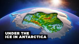
The idea of an inland sea in Australia came about because early European explorers discovered several rivers running roughly to the Northwest, on the western side of the Great Dividing Range. These all run into the Darling River, which runs Southwest, and joins the Murray river. Lake Eyre is a large inland body of water, but is isn't permanent.
Nope, there’s not enough precipitation, even allowing for the fact that an inland sea with attendant vegetation might create more precipitation. The “problem” is that there’s no mountain range like the Rockies or the Andes. A high mountain range to the west might lift moist prevailing winds up high and generate a suitable climate. As it is, all the rivers of Australia combined don’t discharge as much water in a year as a river like the Amazon, the Congo or the Mississippi discharge in a week.
@@josephk4932 Yeah, but it would end up devastating the wildlife there that's adapted to desert conditions.
Hi! I think I read somewhere that the reason they thought there was a Terra Australis was because they felt that there had to be a similar amount of landmass in the southern hemisphere to "balance" the landmass they knew was in the northern hemisphere! Also, please can I recommend that you read a book called "The Phantom Atlas" by Edward Brooke-Hitching - fascinating read, beautifully illustrated and expands upon this fascinating subject :-)
yes that is true, however, when first discovered Australia was presumed to be a island for some reason the British claimed it as a continent.
While Captain James Cook rectified the mistake of Terra Australis, he made two mistakes mapping New Zealand. Stewart Island was mapped as a peninsula connected to the South Island and Banks Peninsula was mapped as an island as he thought Lyttelton Harbour and Akaroa Harbour were connected.
Especially I think to remember you are Portuguese, so I'm surprised you did not mention that distorted / dislocated South America map from Spain that gave you Brasil.
Talking about scale, one French king remarked that he'd lost more land because of his cartographers than he'd ever lost through war.
I've read that Chinese compasses pointed south, not north, so maybe their maps were orientated to have south at the top? I've no idea what their compass needles pointed to, unless they just followed the south end of a needle that was actually pointing north.
The first part sounds really interesting, I wonder what other consequences there were because of faulty maps
Our geographical south is the magnetic north. The needle of a compass turns towards the southpole and we put the north on the opposite side to know the geographic north. Antarctica probably contains the "magnetic rock" that is talked about.
Or so I have been told in school...
@@natanfevrier2367 No, compass needles do in fact point north for the most part. It's just that the "magnetic rock" is actually a group of mountains containing a lot of iron ore in Northern Canada.
@@Compucles go to the Wikipedia page 'north magnetic pole' and look under 'polarity'. The writer of this page has done the researsch. If you want absolute proof, go see the references on the subject.
@@General.Knowledge Actually, that king made that remark after he saw what was the first totally accurate map of France (and probably of Europe to this degree), so it's the previous maps that were wrong. The name of that map is the Cassini map, some youtuber did a video about it if I'm not wrong.
When cartographers have to use their "imagination", they tend to give more room to the place they live than there is really. So when an objective precise map is created, that place is general smaller than in the fantasy maps that preceded.
If you ever do a part two, Scandinavian region is a very interesting example of this:
1. Older maps had Greenland as another extended peninsula of Northern Europe connecting to northern Norway.
2. The mythical island of Thule kept being mapped and referenced quite often in medieval and renaissance maps in the Norwegian Sea: upload.wikimedia.org/wikipedia/commons/b/bf/M%C3%BCnsters_skandinaviakart_%2824957076285%29.jpg
3. The number of peninsulas in the Scandinavian region took a lot of time to settle into what it actually is, going from one peninsula of Norway and Sweden with modern Finland on a vague eastern continental side, to having up to three: Scandinavian peninsula, Finland and the mythical land bridge to Greenland.
4. A bit more niche, but Europe's largest lakes of Ladoga, Onega and the White sea were placed initially a bit all over the place, within the Finnish peninsula mostly, and with the White Sea often represented as a lake.
Do you know if Hybrasil was an actual island or not? I heard it sank beneath the ocean.. I'm curious if it was ever real.
@@SuckMyKiss420 My fave history youtuber, History Calling, did a great vid on Hy-Brasil- check it out!
@@beth7935 Thank you, I will! :)
The story of the Island of California is a bit more complex than that. When the Spanish first discovered Baja California, they did indeed think it was an island. But with in a few years, it was quickly determined that it wasn't (you know, by not being able to sail north without hitting land). So, for years, it was, correctly, depicted as a peninsula on maps. Then an explorer at the northern end of the Gulf of California saw some lagoons where the Colorado River flows into the head of the bay, and started spreading rumors that he thought they might be actually the start of a full-fledged straight (presumably to get himself more exploration commissions). So - despite the fact that people had been recorded *walking* to Baja California around the northern edge of the Gulf of California, cartographers suddenly took this one explorer at his word and started portraying California as an island again. This took about a century to fix, when the King of Spain literally sent more people to walk on dry land to California to prove to everyone that it was attached to the mainland.
Regarding Bermeja, Mexico is actually in North American continent not South America.
Ehh the only thing separating north and south America is the Panama canal
if there was no canal there would only be one continent. America.
@@flamerabbit3500 You could say the same thing about Africa and the Suez Canal, not to mention Eurasia. If Africa is a separate continent, then so are North and South America.
I know in early maps of Tasmania that Macquarie Harbour was often vastly overscale compared to the rest of the island and this appeared in a few maps of the time. The west coast of Tassie was inhospitable and wild for most of colonial history and repelled many surveyors from discovering what lied within. Lake Pedder was also one of these features that saw some repeated errors, namely that the rivers that flowed in and out (before it was impounded in a modern reservoir) were often shown to flow backwards, draining into the Huon. I generally assume that this was because it seemed that the mountains formed a wall to the west that was clearly the source, when in reality, the Serpentine River actually punched through the mountains via a gorge and drained west to the Gordon. Also on Tasmanian west coast cartography issues, the southernmost extent of Macquarie Harbour, a little arm known as 'Birchs Inlet' seems to have not been accurately mapped until modern aviation in the 40's. In reality, it's shape is long and heads in a straight line south, but early surveys of Macquarie Harbour that only peered through it's mouth, misread it as having a swollen, curved shape. This weird error went on unnoticed for a century or so to the point that the latest I've found a map to still show it like this was the 1950's. At that point, aerial surveys were widely referenced and the old misunderstanding was erased for good.
Sure enough: I just looked at the map of Mexico in my 1901 Cram's World Atlas, and there it is: Bermejo Island.
Maybe you should go there.
It's fascinating to think how different the ecology of Austraila would be if there was a sea running through its center like in that map. I would imagine that a huge portion of what is currently desert would have been tropical rain-forest. Imagine what species may or may not have evolved there!
funny because it was rain forest millions of years ago and there are tours in my back yard where you can see ancient croc fossils in the top of the mountains. Some had claws big enough to climb trees, safe to say we love what we got now and the only thing we need is actual growth and money spent instead of city PHD kids that have never even seen a wild kangaroo talk and winge about climate problems when in reality we dont and the real issues are things like Mount Isa has 2.2 car thefts a week and that might sound insignificant but thats in a community of 18-20K and majority of the people here actually work for a living unlike the neanderthal cavemen that we still got roaming around drinking piss instead of living off the land they so badly want.
Just a small correction. Bermeja (if existed) would be in North America and not South America.
This is true! My mistake. I tend to (wrongly) think of all of Latin America as being South America.
@@General.Knowledge
Sheesh. 😬
7:37 As a fellow portuguese, I'm sure it was hard to say the translated version of Fernão magalhães' name
cool
He is from portugla
@@idifjrivhjf5198 That's exactly what he said
@@idifjrivhjf5198 guess you don't know what fellow means
@@cycrothelargeplanet oh
I have heard a statement (I think by Map Men?) that may explain the weird island in Mexico. A lot of cartographers used to add some small false pieces of information as a sort of watermark to indicate that someone else stole their work if it was put into another map. It could be that someone did this and maps just kept using that same piece of information for years. It could be something else as well though.
Africa, Asia and Europe all being connected to each other and surrounded by ocean is actually correct. They just got the respective sizes of the each continent wrong.
This makes Pedro Nunes maybe one of the most underrated genius ever.
I love the idea of Sri Lanka being twice the size of Great Britain lol.
One of the better videos in this year! Good work!
That 1510 Spaniard! "Hello, ladies!"
Imagine living at a time when the full scale of the world was unknown, and that all you'd have to go by is predictions and imagination, with somewhat of an inkling that it could actually be endless. Coupled with the fact that it was all in close proximity to you, as say, compared to the sky and beyond. It was all in your backyard, so to speak, with every inch further traversed being a new discovery in it of itself. Just an incredible thought particularly when the world is so commonplace in our minds today. It would have been enough to keep me awake all night. I don't know how they even slept.
Very interesting video. I like geography and I learn so much things with your videos. Keep it up!
Just found your channel, and I've got to say I respect going over the ones in the thumbnail first. Very respectable!
When I was a kid, I imagined any island was just a dead dragon at sea, then tree grows on the dead dragon body.
Outro erro em mapas da América do Sul do século XVI e XVII era a existência de uma conexão entre o Rio Amazonas e o Rio da Prata que se encontravam no meio do continente em um lago gigante, mais ou menos onde hoje é o Pantanal.
You should see an asian perspective too! There is the Gangnido(混一疆理歷代國都之圖) made in Joseon(Korea) in 1402. It shows the old world in a distorted way. centered around china.
The reason I think they showed california as an island is the giant lake may have had more water a few hundred years ago and no one wanted to walk around to confirm that.
Explorers thought Tasmania was part of Australian mainland other than being a seperate large island during the 18th century when Australia was called New Holland.
1:26
The California Island looks eerily similar to an outline of Graham and Moresby Island. Just a lot bigger.
Coincidence. It’s really just that they thought that the Gulf of California connected to the Pacific Ocean
There was also the "Eupanus Lake" in the heart of S.America. They imagined that the Amazon basin and the Rio de plata basin connected each other in the Brazil's center.
Informative as always
Thank you!
If I recall, many Islamic cartographers had south at the top of their maps. I think one theory for this is that makes the Nile flow "down" on the map, which is how many people discuss rivers flowing.
Really? I thought that was just an American thing due to most of our important rivers indeed flowing more to the south.
People back in the day were either REALLY bad at picking out fiction from fact or much more willing to take things on faith based on nothing but "other places are like X, Y and Z."
The notion of "the southern hemisphere must have a big continent" originated from ancient Greek philosophers who thought that a big continent on the southern hemisphere is a must to balance out the continents on the north.
~10:20 the way we look at the maps is subjective. We simply got used to view them as we do, but there is no "right way". If you zoom out of Earth, do you think our tiny continents make any difference which way they are placed? Again, there is no universal correct way. It is a sort of humans agreement.
Did you know that in the north there is a southern magnetic point and vice versa?
honestly, i'd love to help make a game about people trying to find the 'polus artcticus'
Funnily enough Australia does have quite a large inland lake in South Australia called Lake Eyre. It actually sits below sea level, but is so salty that it is completely unsuitable for providing for any type of irrigation etc.
I've read the passage about the California island. It was vaguely described with no hard location or size given. So my theory is that it was describing one of the Channel Islands off the coast of Los Angeles. But the explorers, going by the description, would have mistaken the Baja Peninsula for an island if they passed the San Francisco Bay without going in. "This must be that island those guys were talking about... Either that or it was one of those ones that we passed a few days ago... We'll have to leave it to next year's expedition. We have to get back around The Horn before the weather turns too bad."
Being the first European Explorers in the area, they may not have had a deadline, but they were expected to return as quickly as possible. So they didn't have time to dawdle and make things perfect. The next round of explorers, having a good starting point, would clarify things.
Combine this with the behavior and competitiveness of Cartography at the time, and you have a mishmash of maps of varying degrees of accuracy. Believe it or not, after the next two or three missions, the California Island maps became less and less common because of the clarification of the later exploratory missions. In fact, those maps were already uncommon by the time Ferdinand the VI made his declaration, and most sailors knew the truth; considering the island maps inaccurate before the declaration was made.
Romans thought that the west coast of Italy was parallel to that of northern Africa and that Rome was in front of Carthago.
A number of early maps of what's now upstate New York, northern New England and Quebec depict Lake Champlain as being significantly wider (east-west) than it is long (north-south), exactly the opposite of what's true.
In 1:22 gotta say, "Las sergas de Esplandián" is actually a book, wrote by Garci Rodriguez of Montalvo, it wasn't by a pope, so... just a little mistake there. Also, I would like to know where did you get that, because I would like to see if it's an old source or something like that :p
Why is Prussias Glory playing in the background LOL
I used a compilation of German military marches as the background music!
Maybe not inland seas, but at least two massive inland irrigation schemes with huge dams have been developed in northern Australia - one around the Burdekin River in north Queensland, and the other is the Ord River Scheme in the north of Western Australia.
However a much better known map mistake was that Tasmania was joined to the mainland - many maps were produced showing this. The fact that it is an island was only confirmed by Europeans in the very late 1700s when Matthew Flinders circumnavigated Australia.
Also, just noting your graphic had a pic of Arizona-style cactuses to represent Australia's desert regions. We don't have those!
Amazing video. Love your channel. I learn a lot
Two other places that were falsely shown on maps are Sandy Island and The mountains of the Moon
A good comparison for these mistakes is how we are currently mapping out the universe and the errors and issues we come across as we do. Most pictures of planets that we see are simply art and imagination, and only until recently did we have a picture of a blackhole. Other aspects of these maps purposes, only hinted on in this video, is propaganda. California was an island full of only women, a laughable notion today, but something that may have gotten a few more sailors on to boats, or at least accept their fate. I suspect the river and sea in Australia was a similar attempt, as no colonizer is going to sail that far to live on a huge desert. Rich fertile land was the goal back then, and they only needed you to believe it long enough until the boat set sail.
Terra Australis resulted from the belief that the land area in the southern hemisphere should match the land area in the northern
Awesome! Thank you!
The funny thing is that those California maps will be accurate in the future, thanks to the San Andreas Fault, which will cause the California region to be separated from the mainland in its entirety.
Now that Redit exists, when people in the future look back on us they’ll think we made mistakes like these
"This map shows Norty America welded onto Siberia". Actually it is tectonically. The suture between North America and Eurasia is in Eastern Siberia.
North America does have a large inland sea. It's called Hudson Bay. But Hudson Bay is shrinking due to isostactic rebound.
One I remember seeing was a map from Viking era Sweden that had Europe surrounded by a sea that was surrounded by land.
There is a river basin that empties into southern Australia, but it’s not a large amount of water compared to other continents.
I love the inland sea of Australia great for tubing
You don't want another place prime ministers could dissapear into
@@dxkaiyuan4177 honestly god’s plan 👏
Hey, hello, how do you make your videos? Because i want to do video like yours :)
Sandy Island is a remarkable story: en.wikipedia.org/wiki/Sandy_Island,_New_Caledonia It is even there on modern maps.
And Frisland was a phantom Island in the northern Atlantic: en.wikipedia.org/wiki/Frisland
Another mistake was the "mountains of the moon", mistakenly thought to be the source of the nile
Another big mistake in early mapping is that people used to think Tasmania was connected to mainland Australia because they had never discord the Bass Strait, they only landed on each side separately. You can just search up "early map of Australia" and you can see just how many depictions show Tasmania connected.
Oddly enough the idea of California being disconnected from the mainland is something I went with in a sci-fi story, set in the far future that I'm slowly writing. After a 6 miles wide asteroid impacted in 2535, N.America was cracked in half and a massive new fault line appeared. Starting in Washington and cutting across the Yellowstone caldera turning down into Kansas and down through Texas. Resulting in high sheer cliffs as the eastern half dropped and the western half rose. This created cliffs from 300 to 1000 feet in height. Another change was that the San Andreas finally did split and the Pacific waters flowed into the gap. This separated the western half of California into a chain of islands I called Pacifica. I even created a map of N.America to show how it may have looked after meager remnants of humanity re-emerged from underground shelters sand caves after about 230 years and began to rebuild.
"Where did the asteroid hit?" Northern Norway.
This is such an interesting topic.
3:20 is also clearly a military utopia design, look at those convenient islands in a row along the delta of the river...you would NEVER be able to get your fleet past that into the lake ...
this is some Admiral's wet dream
“Starting with the ones on the thumbnail” *Everyone liked that*
A navel staring Brit that in 1827 believed that there is a major river on the West Coast of Australia ...
That coast had already been mapped in detail by Europeans for more than 200 years!
I know I'm being pedantic, however Australia does have an inland sea, commonly known as Lake Eyre after the guy who discovered it. Lake Eyre floods periodically and becomes the breeding grounds for millions of pelicans and other aquatic birds. Lake Eyre is 15 feet below sea level and is fed by Warburton Creek. The curious thing is an obstacle called Marble Bar. Marble Bar is just that, a rock bar which stops the Arafura Sea reaching Lake Eyre. So, if you want to make a fortune out of beach side developments just settle land around Lake Eyre and wait for Marble Bar to erode away so the ocean can flood in. It will only take a couple of thousand years but it'll happen. Perhaps when global warming melts the ice it'll flood Lake Eyre, but thats just another dream.
The California Island refered to the Peninsula of Baja California, then the Spanish discovered the American State of Alta California.
Baja California is the original California, then it was called Vieja California (Old California) because the current California is the New California. Time later, they became Higher California and Lower California. When the US took Higher California from Mexico, they shortened the name to California.
Great thumbnail :) have a good day!
10:08 England looks like a tea can lol
actually James Cook did believe he found Terra Australis and claimed it as Terra Nullius as what he discovered was Australia. At that point several explorers had landed there that with them all landing in Western Australia, James Cook interestingly landed on the opposite side. In fact James Cook was sent to look for Terra Australis and claimed Australia for it, thus, why Australia ended up under colonial rule and at that time King George III wanted a penal colony.
Can you please do a video on most safest countries
please do any research on how to read those names (I don't only refer to this video)
Fun fact, in Maple Story (mmorpg) there is a location called Jipangu, which is based on Japan!
In my opinion, the Mercator projection alone is a complete disaster that still hasn't been fixed up to this day.
It was useful for navigation back in the day when ships had to rely on a compass and dead reckoning.
It is still useful for stuff like Google maps where you usually only want to see a tiny part of the Earth, but want to see that without distortion.
Using it for anything else is almost certainly a mistake.
If you want a accurate map use a globe there is no way to show the earth perfectly on a flat map (because the earth isn't flat)
@@TylerMarkRichardson a globe is not something you can carry around unless it's a very small one which is stupid if you're carrying one.. don't sass on my telling me to use a globe
Great video.
These maps may not be accurate but MY Minecraft maps sure are
Sand Island in the Coral Sea was a map error that lasted long enough to wind up on Google Maps.
The Flood waters have been receding, hence, the Saltan Sea, Salt Lake, Dead Sea, and so forth are shrinking
Great video! Tho
would a big canal going from the ocean to a big and deep hole in the middle of the desert in Australia but also in the Sahara desert be a good thing ? I revently heard that most of continental rain comes from continental evaporation and with our "modern" agricultural technics we make impermeable lands that doesn't absorb water..
why not bring ocean into the desert to make it evaporate and give rain, and of course a big sea a a river, it would just be the other way around.. (instead of getting out of land to finish in the ocean from an inland source, here the water would come from the ocean and end in the continent.
The only depression in Australia (large enough to show up in my 1970's school atlas) is around Lake Eyre and that's tiny compared to the size of the continent. So flooding that with sea water would kill most of the wildlife there and not make much of a difference to the climate. So probably not a good idea.
Flooding the Qattara depression in the Sahara looks more promising, and has indeed been proposed several times (including using nuclear bombs to dig the canal). Still wouldn't make much difference for the Sahara as a whole but might add some habitable land to Egypt (or maybe not).
Digging a hole big enough for a whole artificial sea in the middle of a desert is of course completely beyond our current technical abilities.
@@peterholzer4481 the ancient civilations would be able to, but not us.. look at mines.. we can but if no ressources to keep money income.
I bring those who certainly are just our ancestors here because look at angkor vat, I mean just look at everything else like the pyramids or machu pichu
they must have way more strenght and dedication,
and of course much more logic, intelligence, like something that were way above our understanding of matter, physics and all this, like they could control matter, like shaping matter something that primitive people like us would call magic..
yes we are the primitive..
@@jeanbarque9918 I think you vastly underestimate how much easier modern technology makes large scale projects. The Hoover dam has about the same mass as the great pyramid of Giza and is a much more complex construction, but it was completed in just 5 years with a few thousand workers. And that was 90 years ago ... We could easily build a Machu Picchu or Ankor Vat today. There just isn't much incentive to do it. I don't know if the ancient Egyptians would have been able to dig a canal to Qattara at all - it might have filled up faster than they were able to dig it. Today we could certainly do it - the question is whether it would be profitable and politically feasible.
The magnetic rock reminds me as reverse mountain in One piece.
Anyone else kinda wish some of these mistakes were real
one reason they thoguht there must be a massive southern continent, was to 'balance' the world, thinking the south and north hemispheres must have about the same amount of land or the earth would be unbalanced. Astronomy wasn't too good yet either...
I thought satellites solve everything and was going to ask if there are mistakes solved solely with helps of satellites. But then there's Bermeja till 2009.
Why do you pronounce Spanish words with a Portuguese S but English words with an English S considering the English and Spanish S are pretty much identical? Dont get me wrong I'm not trying to criticise i'm just curious and i've always wondered that
Phantom Islands were put on maps to make them look more interesting than just blank spots. And Terra Australis comes from the belief that Earth is symmetric and there must be a larger land mass in the Southern Hemisphere to weigh up the continents of the Northern Hemisphere.
What if this is what California looked it like a long time ago and that San Andreas vault line about the land closer to the other part of land and or what about Continental drift also so that is something to really think about because we're the San Andreas vault line is that pulls the land closer together so that could also be what's going on what happened so eventually one of them places is going to end up under a body of land
Literally no one lives in the parts of Australia shown to be the inland sea, they should create it in real life to drastically expand the habitable land
If viable, it would be very cool yeah!
The last background song is Finska Rytteriets Marsh/Hakkapeliittain Marssi a swedish/finnish song about the 30 years war:
ruclips.net/video/rTQOGpUsqWQ/видео.html
Finnish version: ruclips.net/video/54YSkW4sJU4/видео.html
AYYYY Mount Isa made it on a map apart from queens lands weather forecast and the record 2.2 cars stolen a week story that is on the news again every few months
I remember going in a hotel with an old map and it had California as an island and I thought that in 1600 something that it actually was an island
12:07 AM Dude
there are different timezones across the world
@@racereb me know Just Kiding
Bermeja was not located in South America but in the Gulf of Mexico, which is North America
Interesting!
Another was the Mountains of Kong that were thought to be in West Africa.
6:00 did he explain the grand line in one peace ok