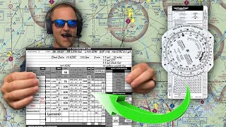
Ep. 114: X/C Navigation Log | VFR Cross Country Nav Log Calculations

HTML-код
- Опубликовано: 16 июн 2024
- Written Prep BootCamp and Checkride Prep: learn.fly8ma.com/courses/priv...
Start to finish, how to fill out a VFR cross country navigation log
#fly8ma
Your Support Makes our Videos possible! Thank You!
👉Take our online PILOT GROUND SCHOOL✈
🛩️Private Pilot:
-Everything you need to know start to finish
-How to choose an Instructor
-How to perform the maneuvers
-Airspace
-Landings
-Oral and Checkride prep (premium version)
-And so much more! Try it for free with the link below!
bit.ly/2I3evAd
🌦️Instrument Pilot Ground School:
-Learn all the abbreviations and IFR speak
-Approach Plates and Procedures
-Airspace
-Rules and Regulations
-Systems
-Real World Scenarios
-Accident case studies when things went wrong
-Written test prep
-Oral and Checkride Prep
-Etc, Click the link below to check out the course!
bit.ly/2I3hZTr
🛫Commercial Pilot Bootcamp:
-Learn about Holding Out
-Maintenance Requirements
-Systems
-Airspace
-Rules and Regulations
-See full oral exams and checkride videos
bit.ly/2I5W4eo
Check out our many other courses too!✈
-Tailwheel
-Crosswind Landings
-Weather
-Airspace
-Seaplane
-Sport Pilot
-Spin Awareness
-Accident Case Studies
-And more! Click below to see all courses:
bit.ly/2I4whDp
Support us at: / fly8ma
Check out our site at www.fly8MA.com
The FLY8MA.com Free Online Ground School for Sport and Private Pilots is available to everyone as a means to make flying more affordable and increase learning for everyone. We are funded with the help of our viewers and subscribers to our website: www.fly8ma.com and our Patreon page: / fly8ma
Every dollar helps us to grow our project into a comprehensive online ground school for Sport, Private, Instrument, and Commercial Pilots. We greatly appreciate all of your support and hope you will share us with your friends and family in aviation.
FLY SAFE!
-Jon  Авто/Мото


You know you’re confident when you do the whole thing with a pen
I thought of the same thing !! Lol
You got that right!
I watch this video AGAIN, 6 months from the first time I watch it and it makes perfect sense now! First time I watched it I was totally lost, but now it make perfect sense. This video is more for an advanced student vs a new student and a great refresher! Good job.
@@allenustianowski9757 Lol, I haven't watched it in over a year. I'm about to go for my CFI checkride next week. I now can use a pen
Update: I passed my cfi and cfii checkrides and am now instructing
Erasable pen gang
I think I'll just walk!!!
I love your videos. I have a pretty decent understanding of the nav log stuff, but this was easily the most confusing video I've seen on the channel.
This video is definitely more intended for pilots who have done Navlogs before and need to refresh. I could not imagine a Student Pilot being able to follow along. Great video though
As a student pilot that makes me feel a lot better😂
@@colbyjamesreynolds1516 one year later, do you better understand this video? I'm a student and I thought I was lagging way behind watching this.
Trying to prep for check ride. Also very very lost. Feels really overwhelming
At several minutes in, I tuned out. Rapid/overwhelming info isn't useful to this 60 yo student. It's a great refresher, I'm sure. But...
Yup pretty hard to follow along lol I have mi iPad,calculator, charts, nav log and still can’t keep up lol
My dad was born and raised in Charlotte, MI...thank you for pronouncing it correctly!
Seriously archaic! This is exactly why computers were invented. Very nice to still be able to do this by hand and a great learning tool to get how the information is derived, but it is inexact, prone to making mistakes and slow. You did a nice job putting it together though.
This is exactly what I needed! Reviewing nav logs was on my to do list for today, so I'll definitely watch this. Thanks for your awesome videos Jon!
Will You’re aware that the video can be slowed down and replayed over and over, right? Creators can’t win on YT. Comments like “video was too long”, “not long enough”, “too much explanation”, “not enough...” Perhaps naysayers should try putting in all the hard graft to create their own videos before finding fault?
What's *really* rewarding is, after doing all this stuff manually, is actually doing the X-C -- and it ALL freakin' works out really close to plan.
Excellent , very detailed explanation that tied together learnt theory about performance calculations and all that "true-calibrated-indicated-ground-pressure-density" etc etc to practice . Thanks for posting!
Wow! That was fun. I haven’t used that stuff in years, just brushing up reminds me what flying was really
all about when I was learning to fly in the ‘60s. Thanks for reminding me that we didn’t need gps or an autopilot to fly. I’ve so lazy I fly a glass panel and an autopilot on my bush plane Simulator. Thanks again for sharing your expertise. I always enjoy your videos !
Thank you so much for taking the time to make this video! I know it must’ve taken you forever to make the video but you are helping a lot of student pilots
Appreciate the comment and thanks for watching!
I totally agree with Hesam's comment. This was a huge help for me. Little fast, but that's why they make the replay button. A lot of assumptions and you may not every get this detailed but totally agree you should know how and why you do this.
Awesome video Jon. Now that I’m so close to the check ride, I needed this video desperately.
Thanks for making this! I learned the Plotting & Wind/GPH Conversions separately, so it's good to see all of this put together. While some say you're going too fast, I appreciate the brevity and can easily go to a more detailed video if needed for the particular component.
Agreed. Could have gone a bit slower on the calculations with the E6B.
This was extremely helpfull. To those that think he went too fast...note the pause and rewind capabilites of youtube. Magic!
Ron Toms preach it Ron
Thank you for this video. cleared up some stuff for me with using this log. just started using this format Nav Log
All these negative comments but I must say, This helped me out. I did a ground lesson with my instructor then watched this video. Made everything link into place in my brain. Sure, most have gps navigation today but for folks needing to learn the basics this is great..
I'm a new CFI, and have assigned this video to all of my students in the cross country stage.
I've been assigned this video and I don't even have my private pilots license yet XD
You just made this seem impossible honestly I can’t comprehend half of the things you’re talking about cause you start talking about something else before I even have the chance to comprehend what you were just talking about. Thanks for making this seem impossible!
Cole, it’s called learning. Study for a few months & it will seem easy..just takes patience..
Thank you for this vid. Definitely helped out as I planned my first XC from BJC to CYS.
Glad it helped! Check out the site for more vids: www.fly8ma.com
I have that same pen, used it to plot my first cross country today also using this video.
Small world man, small world.
Your phone vibrating at around 18:45 tripped me out I thought I was getting a call lol
There are literally 113 tutorial videos before this finale to most PPL cadets. Any man can appreciate all the efforts that this man has put into this tutorial series.
Jon, you have lost your ever loving mind.!! I ain't never going anywhere if I have to do all of this!!
Great video! Heads up that in the 172, your enroute climb can be higher than the table. (See 172S POH, section 4-25, "Enroute Climb: Normal enoute climbs are performed with flaps up and full throttle *at speeds 5 to 10 knots higher than the best rate-of-climb speeds* for the best combination of performance, visibility and engine cooling.")
So you can round up 5-10 knots as needed to get even numbers, and you're technically following the manual even more precisely. ;)
Very timely !! Comm checkride coming up !!! Great vid as always !!
Glad it helps! The commercial checkride prep course is almost live on the site at www.fly8ma.com !
As a Canadian ppl holder, revisiting your works help me set a starting point in my material reviews. Good to have you back in the few valuable instructors pool.
I always give your videos thumbs up. Great resources!
Thanks! Share us on Facebook and with your friends around the airport to spread the word!!!
amazing explanation, great job. Many thanks.
Your video was very helpful. Excellent job!
Thanks for the video, you did a great job!
Thanks for reminding me why I didn’t do well in this area. But I did get it once upon a time. So, now I’m trying to get back into it and hoping to better understand this again.
You can do it!
I just spent my night planning a xc in Xplane. Using this video i was able to plan a 51 min flight that ended up being 52 minutes. Landing wasnt so great. Now to find someone to teach me in the real thing. I also cheated and calculated a vor radial and distance to vor as a checkpoint but to be fair, the computer graphics dont lend well to VFR checkpoints. Thanks for this great vid. Oh and I'll echo how i feel this way is useless with GPS but if FAA wants me to learn it, so be it......
Thanks man! Great video and explanations, definitely won a subs
hey man awesome video!!! this helped me loads
Thank you very much!It’s very helpful!
Great video! Thanks for taking the time to make it!
Of course!! Feel free to share it around with your flying friends!
Great video! Thanks
Thanks for your investment of time. That was a very good explanation of cross country planning.
Of course... Glad it helped ya!
So clear thanks for a great tutorial
Great video and great instructor, thanks much!
Glad it helps ya out! Check out some of the new courses on www.fly8ma.com !
Doing this now in my training. Thanks!
Glad it helps ya out! Check out some of the new courses on www.fly8ma.com !
your the best! good easy to follow.
Super super helpful. Thanks so much.
So, I totally get the system and the math, AND I thank GOD for the electronic Flight Navigation calculations that SkyVector or Foreflight do FOR YOU
Thank the programmers ;-)
This video helped me get through my private pilot training!! Amazing job
Glad it helps! Share it around!
New drinking game. Every time OP says "go ahead" have a shot or a beer.
Doing Nav logs by hand really makes you appreciate Foreflight. You have to do this manually like this so that you understand what is going on. Then when you get Foreflight you are amazed. I still like to use the paper maps and platting at times to be sure I find the correct VFR points. I also like the paper Nav log because it has all of the infor on paper in one place. Be nice if There was one in excel that would help with the manual calculations.
I appreciate the technology nowadays, but I still respect this type of planning and It's how I learned years ago. E6B, it's been a few moons since I've used that calculator, haha
For the cruise performance chart did you use the temperature aloft or did you just use the airports temperature? Same for the altimeter setting ?
This was so helpful, thank you! One thing I'm confused on: Why didn't you take into effect/interpolate the Temps for the time,fuel and distance to climb chart? The chart at sea level lists standard temp but the temp for the flight is -6.
starting commercial soon...crazt how u can forget some basic such as toc.. lol
This is so difficult but understandable
pilots phone starter kit, E6B, AvWeather, Tinder and bumble
Yeaa I think hes more confident to show his phone apps than his flight plan knowledge lol Tinder 🔥🤣
That was excellent!
Glad it helps! Share us on Facebook and around the airport with your friends!
Great informative video, just have trouble seeing what you put down on the nav log because your finders are in the way most of the time.
this is just pure maths, I found the VFR cross country flying hard!!!
thank you! its awesome..
Great videos!
Very helpful. Thank you
Regarding the altimeter setting to obtain pressure altitude for cruise; would it be suggested to get the pressure setting for the departure airport and the destination airport and average it out to get a better estimate for the altimeter aloft to have a better understanding of what the cruise performance is?
great instructing.
Happy it helped ya!
do you teach out of willow run or ann arbour, no rush on response, I like the way you teach, appreciate all your videos and experience thanks mike.
Do you factor in declination? Magnetic north is usually off by a few degrees depending on the time of year.
Thank you John. Great tutorial. Qq: the -6c° you are using for the cruise perf chart, is it from the metar? If yes, does it make sense to look too at the forecasted cruise oat? Thank you. Great channel!
this video help me a lot thanks
Happy to hear that!
Best video for X country planning. Perfect to send to my students.
Glad that it helped!!
OMG just do it!
Just top it off when flying short distances :P.
Takes me a while to fill in the navlog, and I also get sort of picky when it comes to marking distances on the map. Even though climbout may take "5 nautical miles", I know I have to climb out to 1000ft AGL before I can even begin my turn to course, so I may arrive to top of climb at an earlier point since I did a bit of detouring before arriving on course. Flying out of busy, towered airports makes it trickier since you're likely to get vectored around before you can proceed on course (I was several miles North of my plotted course due to vectoring but eventually made it on course).
Thanks, this was very helpful....
Thanks @fly8ma this was hugely helpful as I do my first cross country flight plan by hand!
To those saying this is too fast or confusing, if you can’t follow along with this you might want to review ground school again...
Great video, thanks Jon! Out of curiosity what kind of plane is that in the last minute of the video-it looks really nice!
Tecnam Twin, pretty cool airplanes for training in!
If your true course changes (like slightly alternating course for way points) do you have to find new TAS and GS?
It's kinda funny how this episode is #114, my long dual night xc is 114 nm in total! Cool coiwinkydink
I've got that white out part down!!!!
I feel like everyone does cross country planning differently 😒
And every single flight plan log looks different
Yeap !
I swear🙅😂
and every time you get in a new cockpit, the controls/instruments/seating, ergonomics, etc., are all different. What's the same?
Physics, chemistry and gravity. Maths. The basics:
www.amazon.com/Stick-Rudder-Explanation-Art-Flying/dp/0070362408
I once read a story by a guy who had the great good fortune once upon a time to right seat with Yeager in a seaplane Yeager had never flown. He said Yeager's every landing was *perfect*.
Did you know Yeager used to own a Part 103 Quicksilver?
I think the more different ways I learn to do something,the more firmly I grasp the underlying essentials.
Variety: it's a feature, not a bug.
Yeah. Everyone gets to their destination... eventually.... LOL!
Not a pilot, though I did follow what you did here. I've never thought about much you'd need to write down in flight. What do you recommend for a left handed pilot flying something like a Cirrus, with a side stick? Should that pilot fly from the right seat, but then they'd be farther from the instruments. Or are lefties limited only to flying aircraft with yokes? Or regularly use autopilot to free up their writing hand to record instructions from ATC?
Loved this. Super helpful. But 42.1 minus 2 does not equal 42 gallons.
Still loved the video. Keep them coming!
After watching all of this I am so far behind that I actually think I'm ahead. My plan B - take up sailing . . .
Wouldn't check out just yet....sitting down with the right CFI for 30 minutes or so can usually sort all that out!
Thanks - just started my PPL on Sunday - at age 59 - your videos are amazing and will be checking in as a patron.
Follow your dreams...
@@BoomerBlogging Seeing this comment 5yrs after you posted....hope you got the PPL. I started late too (50), just solo'd and x-country is next. Slower to learn than when I was a teen.
I guess i was really paying attention to your video, i even saw your Tinder app on your phone. Lol
The FAA allows you to use the electronic EB6 computer in the written exam now and I am perplexed why the DPE still require people to fill this out. It is literally done once during the check ride and will never be done again. What is the use of the exercise again?
I know this video is already long but, He spoke to fast and went way to fast through this. thank goodness for the pause button. Also, I like filling in all the squares. Overall, I like this guys style of teaching.
What plane is that?...Aerostar? With overhead lites? Analog is the gateway mathma . Wish u did more math on the wiz wheel...quick 1-2-3s always worked for me. This then that. I’m liking my fly8MA hoodie!
I must take exception with using TOC/TODas checkpoints on the flight plan.....
They are valid and should be used as they require different fuel consumptions as well as different distances/air speeds than when in cruise flight. Also, your ETE and ETA will be off if you do not account for TOC and TOD properly.
Big swag shout out to Ken Burrs @ NAFC for showing me this before my x-country 🐐
Good gouge, but gotta say the PA-28-181 (Archer III) POH did not make things easy. Figuring GS is still tough. I had to do a lot of hitting the pause button, and replay to get this down. Still, THANKS A MILLION. This is the best video I've been able to find on the subject.
I feel your pain on the Old Piper POH :)
Happy New Year 2018. Hi, I like the plotter you are using, with the compass rose on the end. Who makes it please? Thx.
That plotter is the wind slide part of a Cessna flight school E6B. It’s flight computer and plotter all in one device. It’s a great emergency backup in the cockpit. I picked one up for a couple bucks on eBay.
Do you have a pdf version of that nav log to follow along?
Hi, thanks for the videos, they are helping me understand nav logs. I’m confused about what values to use for calculating TAS. On my cruise performance chart, it uses pressure altitude. For each of my checkpoints, if the true altitude OR the pressure altitude has changed, do I need to re-calculate the TAS for that checkpoint? For instance, my originating airport pressure altitude is 8740 (true alt is 8500). By the time I’m halfway along my route, my true altitude is 7500. Do I need to find the new pressure altitude at that point in order to find that point’s TAS? On your chart, all of your altitudes are the same, but are your pressure altitudes the same? I also don’t see any place on the log for describing a climb from the TPA to cruise, or where I would account for that change in altitude (and again I don’t understand why we are sometimes using pressure altitude and sometimes using true). Thanks! -Mary
He’s using pressure altitude to calculate performance.
Fantastic, now a challenge for the viewers is to do it all again with the RPM at 2.1k to see if there's a fuel savings.
For PPL practical test, do you do all of this before it starts or while the DPE is over your shoulder?
Beforehand, typically. Which is kind of moot, because the most volatile part - wind correction - makes the most sense to do immediately prior to the flight. But the DPEs also know you'll probably never ever do this in your life again, so they let you do it at home and bring a properly filled but out-of-touch with reality nav log to the exam. Sigh.
A good check point I love is VOR checkpoints. That way I can locate where I'm at at all times and locate myself on the sectional chart...
with the speed you speak, this is good for those that know the subject. why would the ones knowing the subject watch it this? oh, ok to pad you on the back...
Dankie/ Merci. It is much better to understand. MMmm.... 1 gal = 3.7L! 50Gal = 185L quite expensive too. Thanx for the video.
Glad it helped ya!
@@fly8ma.comflighttraining199 Thnx. To make good decisions, you must have good info. How to get out of ZA (and back)? Now, sins 1994, things have really change. There is only two ways. Ship of plane. Ship is cheaper and longer.(2 Kind of ships: Cat.[slow]) & Classic [slower] Plane is fast and expensive.! The closest First world land is St. Helena (Eng) & Reunion (Fr). It was not in that video. Airport tax in is also a factor. $150 for a international airport and municipal airport is $100. What kind of small plane can make the jump? What is the last international airport on the ZA side? Durban/ King Chaka Zulu or Nelspruit-Kruger International? Lots of information... I
Sure be nice to automate this process. With all the computer power around someone should do it.
What plotter r u using?
How do you expect the altimeter setting if you're planning to fly the next day?
Same question here. I got to the 8 min mark and stopped because i'm unable to predict future barometric pressure.
Pro tip, use the 60 minutes used for planning and get in the car and get a head start.
@The Punisher is he wrong though
"Where we're going there are no roads!!!!"
dear god... I'll do this once, for my PPL checkride. Or if I ever need to fly several hundred miles over the ocean in a pre-digital aircraft with a 6-pack. Where a paper map, the mechanical compass, an airspeed indicator and a wristwatch - would be my only means to guestimate my position and find the island or aircraft carrier - the only place I could land, within hundreds of miles of open ocean.
But, only an insane pilot would actually go through all this before a local VFR flight within the continent. Even an interstate one. Heck even an IFR one...
It gets quicker and much easier if you practice 👍
How do I find the time of my E6b when my distance is less than at least 10 NM?
No way? You're from Michigan too? Have you ever flown to ptk or ozw?