Integrating Google Earth Locations into ArchiCAD 17 and Creating real Contour Lines

HTML-код
- Опубликовано: 28 авг 2024
- in this tutorial I will show how we can import specific location from Google Earth and then integrate it into ArchiCAD so we end up with real contour lines for the project location.


The most chaotic tutorial ever....
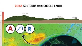
The altitude you took from google earth was not the altitude of your placemark, but your eye altitude, it says right next to it. It's the height you're hypothetically looking down from.
Nice trick! Contour lines can also be made really easy by using Cigraph Architerra 3.
Right Odd,
I just tried to present the idea using native tools in the software !!
in my next coming movie I will import the points from AutoCAD surveyor plan and I believe you'll like it.
thanks for your comment
wow, i was interested at first, but all that looks a really unnecessary long process. It could work fine with 5 cotourn lines but what when you have, lets say, 50 of them? do you really have to go one by one? and then trace them one by one again? why don't you simply do the job in sketchup in one click and then export it to dwg and put in into archicad?
not to mention you will have a set of 3d morphs which would unnecessarily increase the file size dramatically...
that's right Enes
my point was to achieve a fast solution for simulating small chunks of the project and then use it in my ArchiCAD model. however when the whole project will be just modeling the site as it is on the ground then I'll probably ask the surveyor for his grid points map and insert it as dots with elevation in ArchiCAD and finally connect the dots.
Muaz Alnajjar y I got that. I've tried to find a way to do that too in archicad alone for a while but at the end of the day sketchup will do the job way better, faster, easier and lighter than AC. Then you just import a a set of 3D LINES (.dwg) and instantly create a mesh out of it in archicad. Just saying that going thru the contourn lines one by one is really non-efficent to me and the give-a-thicknes to the moprh really kills it since (i don't know why) morphs are really "heavy" to deal with. I hope Graphisoft will come up with an easy way to do this inside AC alone. I'd really like a direct tool to just get contourn lines out of a mesh/morph. Input the desired distance and click, done.
let's keep dreaming...
Enes Libohova let's keep being unfriendly.
this is great for presentation and design phase but not for legal documents. I recently used the site contours and there was a discrepancy with the council contours...luckily its student project...
I'm having issues with image not merging into ArchiCAD 18 along with the topography. Do you know if there are any settings i might need to switch on to be able to see it?
Hi. Thanks for a great tutorial. Waiting for the next one !
Also, how to make the sat image show up in Floor Plan or 2D view. I remember seeing a tutorial on the matter sometime ago but somehow not able to do it, like scaling, aligning, etc.
Thanks
thanks for pushing me making more and more for ArchiCAD.
in order to make the image to be viewed on floor plan, please go to where you've stored the kmz file in addition to embedded library that have the new GDL object there (you'll find 2 file; the GSM and the texture "photo") now you have to take this photo and attach it as a texture (surface) to a "same size slab" on your floor plan.
another way is to add the photo using the figure tool and then push it to the back of the seen by r-click on it and choose move to ..
Thank you! I was wondering if there is any way to grab
terrain form Google Earth Pro? There, terrain is better and a lot
more detailed, and buildings as well! Actually there is a way to do it through Rhino with RhinoTerrain but it's impossible to find the software...
Hi Muaz, I'm trying your technique and strangely the mesh is coming in mirrored. Google and all the copyright text is mirrored and the image of the site is mirrored. I checked the topography from another source to confirm I'm not just looking at it from underneath. And I also drew a quick four walls and roof in archicad to confirm which direction is up. Any ideas how to correct this?
Hi! So you have left importing the .kmz, and imported the .skp 8. What .kmz is for?
the struggle is real
Is it true that you should purchase sketchup so you can use it in this way for your work?
I like your Turtorial but ihave a question.
Why in my project are only 6 lines after i Merged skp file not like you Alot of green lines. Thanks I hope you understand what i thing.
Dear
Can you tell me name of your Screen recorder
Because of its clearly recorded.
awesome trick
The Google Earth surfase why it isn't any more in ArchiCAD17 the real image in 2D, as cover fill? How can I redo it?
thanks for share, but how to open google earth? does it open in archicad or just open in google map?
you have to download it separately from google
just google it and press download and get the normal copy and you're there
Muaz Alnajjar thanks, i will try
Hello! Does this way still work on Archicad 22/23?
thank you very very very much
prepare better next time when you upload a video....
oh it is very fine! can I conduct that in ArchiCAD16?
thank you for the tutorial but its total chaos! it made me nervous watching it... :(
thank you Phi, what exactly you were upset with?
the to do list is great but you give too much information. for example: it takes you 2 minutes to explain the location settings(11:15min) when inserting the kmz part which in my opinion is way to long. 20 seconds max.
there are too many mistakes. its an upload not a live feed, just edit it out. and you repeat the mistake 3 times. again just edit it out.
thanks again Phi. unfortunately I've come to learn that in a hard price. my other tutorials on rendering in AC + in CineRender had the same review "too much info"
however it all came from the point that I've struggled a lot to learn that so I did wanted to make easier for other professionals to understand.
I know for sure it takes longer to watch but it will utterly let people get the idea behind the technology.
I'll definitely take care of that in coming tutorials :)
toooo tedious! its way easier to just google earth the image into rhino and use the plant library and get the entire contours in less than half the time!
I'm interested in this method could you please message me some more details thanks!