How to download SRTM DEM from Open topography

HTML-код
- Опубликовано: 2 окт 2024
- #PleaseSubscribe, #PleaseShare, #Download_SRTM_DEM,#digitalelevationmodel, #opentopography,#howtodownloadsrtmdemdata
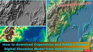
In this tutorial, you will learn how to download SRTM DEM from Open topography web portal with a resolution of 30mx30m .
The type of digital elevation data demonstrated in this tutorial is SRTM, which stands for Shuttle Radar Topography Mission. You can download the following three types of DEM data from Open Topography web portal;
1. USGS 1 arc-second Digital Elevation Model
2. USGS 1 meter Digital Elevation Model
3. Copernicus Global Digital Elevation Models
4. NASADEM Global Digital Elevation Model
5. Global Bathymetry and Topography at 15 Arc Sec: SRTM15+ V2.1
6. Global Multi-Resolution Topography (GMRT) Data Synthesis
7. ALOS World 3D - 30m
8. Shuttle Radar Topography Mission (SRTM) Global


what is i don't have ArcGIS? you have to pay for it, right?
Best and easiest method and website to download DEM, check it out.
Keep watching 👍
It's a very easiest way to download SRTM DEM i have ever seen. Thanks for your nice tutorial.
My Pleasure
For which year this data belong to. ?
produced in 2000, released in 2015
this data belong up to 2015
I selected an area then submitted it,but the total size was only 8 mb !!!!
DEM have no relation with MB
can i chose any wgs utm coordinate
No,you have no option to choose projected coordinate. You will be able to download DEM with geographic coordinates only. You can easily convert this GCS projection. Please follow my another tutorial “How to change the projection of a raster in ArcMap or go to this link : ruclips.net/video/TPhPgdTRG88/видео.html
Great Job. I have learned a new thing
Glad to hear it!