How to read Latitude and Longitude Coordinates

HTML-код
- Опубликовано: 6 фев 2025
- Check out products related to Geography, Travel and the Outdoors on Amazon:
www.amazon.com... (Paid Link)
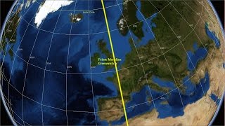
Latitude and longitude is a coordinate system that is used for locating any place on the globe. Key terms covered include the Equator, Tropics of Cancer and Capricorn, Arctic & Antarctic Circles, the Prime Meridian (Greenwich), the antipodal meridian, the northern hemisphere, southern hemisphere, the western hemisphere and the eastern hemisphere.,
Globe images of the Earth are adapted from NASA World Wind.
A better quality version of this video (in terms of audio quality and accuracy) can be seen here:
• How to read Latitude a...


I'M A 50 YEAR OLD MAN AND I HAD TO LEARN THIS TO INSTALL MY SOLAR PANEL ARRANGE.. tHANKS for uploading.
I have a social studies test tomorrow and this was really helpful.
Thank you!
Its weird how some comments are days old, but we all know most of us are here cuz of school :(
lmao
Fr
Same bro
Same fr
I’m not in school but I’m here because I was bored and wanted to buy a GPS but have no clue how to interpret coordinates 😂😂
The Paris meridian is a meridian line running through the Paris Observatory in Paris, France (now longitude 2°20′14.03″ east.) Until 1911 it was a rival system to the Greenwich one. I do not know what the gaps were between meridians. Somewhere on the Internet there must be an answer to this.
It's fun to learn about all the destinations you can't travel to in 2020.
Sydney Opera House:
33°51’26” S, 151°12’52” E
Uluru:
25°17’58” S, 131°00’58” E
Mount Cook:
43°35’41” S, 170°08’30” E
My left ear is thankful.
😁😁😁 yes
8 years later. If you still alive reply me
@@ruslanjumatov6518 he isn't alive I killed him👹 muaahhahahaahahahahahahha😈
@@LifesBetterOnSaturn 😳😳
@@yuridanylko you're next watch out😈😈😈
Thank you for this video! We're about to locate volcanoes in our country using a map and a set of coordinates only. This is very helpful.
is it just me here from online school work?
Aviation school work here 😂
Nope teacher send me this vid that she said i had to watch lol😂
Nope prep for geography end of year
I also have to do it
It’s actually fucking crazy that this guy is my current Geo teacher lol...
audio is not stereo. i am able to hear only in one side of earphones.
in 2012 im pretty sure thats the best you could do...dont hate
Lmao yeah, I was trying to fix my speakers til I realized the problem was the video, not my equipment...
2019 here :D
Ugh same
Not as complicated as I thought it would be, but still will need to watch a few more times to get it to stick. But it seems manageable now.
Side note, about 10 +/- years ago, I was in Arizona for a rodeo and drew a bull named Uluru. Never got the chance to ask the stock contractor what exactly that meant. All I knew it was Australian and I had been curious ever since. Why that insignificant memory stuck around for this long is beyond me.
Haha thats funny
Did anyone else go def at 1:09 ??
If your speakers are on loud... can't say you haven't been warned!
RollOut82 yes
@RollOut82 almost jumpscare
Edited due to typo
OMG - thank you so much for posting this. Perfect video to explain perfectly how to read lat and long coords for a programming I am developing.
My teacher forced me to watch this
same lmao
Name Stealer ikn same
same
Nickster2102 😂 same
Who gives a shit nega
Hell yeah now my left year understandings longitude and lattitude
Thank you very much, I wanted to understand how to find the Longitudinal and latitudinal extent of a nation, this helped very much.
Excellent! The video summaries most important concepts!
thank you for making an amazing video to make us study and understand what an amazing person
Thank you so much! This makes so much more sense now.
No Thanks please explain to me I have test tmr
TheDerpy Kid So basically the Latitude is a sideways measurement starting at the equator, measuring north and south. The Longitude is a vertical measurement at the prime meridian, measuring east and west. When writing the latitude and longitude, write degrees north or south for latitude first, and then degrees east or west for longitude after. I'm so sorry for the late reply and I hope it helps... its pretty hard to explain as you'd need a paper for it. Good luck on that test Hun ❤️
I have a social studies test today, I’m watching this in the morning
Oh sad
lol same but for me its an exam
Just south of the Pyrenees from what I can tell. Between some towns called Berga and Manilleu.
This geo exam made me watch this !!😊
Thank you for making this video (was very helpful)
very helpful for my exam, thank you! Very interesting
Thank you for this educational video. Much appreciated.
Thank you I think we can shall may ( or any suitable helping verb ) understand the importance of studying observing the changes in earth s latitudes and longitudes............flattening and bulging of areas and how our activities like deforestation hurting women ( or men ) can affect its rotation and deviation between magnetic and geometric poles
This is why the earth is not flat
Darron can I pick your brains again. The Paris Meridian runs close by the village of Renne le Chateau in the Longuedoc. What is the closest parallel to Renne le Chateau? And did the Paris Meridian have a different set of parallels from Greenwich?
Are you still alive?
0:35 thankyou latitude is read 1st & longitude is read 2nd. Much looking elsewhere no one seems to think that could possibly be important.
It has nothing to do with speed.It is about location. (unless you are referring to how fast the Earth rotates) It is more to do with how lines of longitude, the Earth has been divided into 360 meridians (representing the 360 degrees of the earth). That is 180 degrees east plus 180 degrees west. Every 15 degrees longitude represents one hour. 15 degrees x 24 hours =360 degrees. 24 hours in a day.Each lines of Each of those meridians is further divided up into 60 minutes.
Excellent. Exactly what I was looking for.
It confuses me that the horizontal lines measure north to south when they run east to west and the vertical lines measure east to west when they run north to south..why is that?
Just imagine you slice a sphere along the Equator line. You’d end with a top (north) and a bottom (south) half. They run horizontal, but create vertical divisions, and same idea applies for longitude lines.
So if you keep slicing the top half, the way to identity them is to think about the vertical increments.
Thanks so much. The videos have been helping me and that of some colleagues in Ghana Geographers Association. We are really grateful to the administrators.
Thank you, good education.
Very well explained. Thank you
Thanks. Am going to use this on an article on my blog tomorrow!
Just what I needed to know, thanks!
I'm so lost
same
same here... this confused me alot i have no clue how i will do in my exam tomorrow but i will try my best
Carter Busby how it is so easy
Heyitsjust Yeneth you should not be
?.. this is the most simplified explanation how are you guys lost lmfao..
Thank you for the great video!
This was a great insight, you have helped me a lot!
Why is the sound of this video so weird when i wear my headphones, i only hear the left side of my headphone
your headphones are broken m8
@@richardthavendran932 No i can hear the left side on my tablet so the video is kinda made that way
same
Great video - thank you for your time, effort and knowledge :)
Brilliant. Better than GPS. Thanks.
Good explanation sir😊😊
Thank you🙏🙏
This is a good intro video explaining how to read mapping coordinates... easy to follow. Has a challenge exercise at the end.
great dry tone to the edification. learned some
When the coordinates say "Sixty minutes", what speed are they calculating that at?
GO NZ
Donald Ducky f___k
Incorrect vocabulary: 'Horizontal' means along surface, 'vertical' means up and down along the gravitational gradient.
The speed of the earth's rotation explained it. Thank you for your help. :)
No, sorry. Despite the use of minutes and seconds, this isn't about "time". It's all about how a single degree is divided further into smaller units, i.e. minutes and seconds. 1 degree = 60 minutes = 360 seconds.
I still can’t find my car keys 🔑
I understood something, but don't know what I understood.
I love YT. Thank you.
My favorite coordinates are 10 deg longitude and 49 deg latitude with the geodatic datum Potsdam or Rauenberg Datum. Weird, isn't it?
But there are also numbers after the 60 minutes numbers as like the coordinates of this airfield in the caucasus region: 41.55.54 N 041.51.33 E How to get those last numbers? Are those the seconds?
watching this because im lost in Minecraft Earth 1:1. I want to find canada please help
This was very helpful for me! Thank you.
Who else has AP GEOGRAPHY TEST AND ARE STRUGGLING
Not ap, but I'm severely struggling rn 💀
Not an AP but i have MYE coming and i am not ready
good video at all. you can increase your primary knowledge by this video.
well done, well done..... I appreciate your time and efforts. It has helped me..
1:08 the random music scared me
Oh my god jumpscare at 1:09 (btw ty for the help)
Very useful, Toodle-oo
I'm in grade 9 and my teacher doesn't even teach us this. This is important to learn. In geography my teacher teaches us kindergarten level things. She asks questions on test like, "which city has a longer name? Which country has a larger are? How many mountains are in this area?"
School work thanks
I have a compass app that tells me degrees and second. Now I get it. Thanks a lot.
thanks you explain it very easy to understand
wonderful. thanks for your time and effort
helpful, thanks!
I need this to do my homework.
And I still don't understand.
At 1:10 and at 1:15 you said 22.5 degrees but on the screen it says 23.5 degrees ??
22.5 degrees is an error in the video which I dealt with by putting the correct 23.5 degrees on the screen.
Greenwich is pronounced 'Grennich'. Excellent video.
502 flat earthers disliked this video
I liked it
I liked because it is an animation of earth not the real video of the earth
this is no joke my geo teacher mr Gedge LMAOOOOO
Great!
thank you for your information
first time i have gotten homework in a while lol
Thank you! I understood!
Great video.
So what are the readings of the three places....? I want to check I have these right =)
+Lana Aitcheson
Sydney 33° 51' S Long151° 12' '' EUluru
25° 20'' S 131° 2' E
Mount Cook
43°36'S, 170°09'E
+Darron Gedge's Geography Channel great thank you! What happens in the case with a country exactly on the equator or meridian....? For example Kisumu, Kenya.... this is a tricky one!
That depends on how precise you need your coordinates to be. If you are talking just degrees it would be just 0 degrees. But if you are using degrees, minutes and seconds then you are likely to have a precise location in either the northern or southern hemisphere.
I was more curious than anything =) so there is no N or S needed. clears it up, thank you! you are amazing!
Lana
I hope my teacher Mrs botsio sees this comment. That possibility it’s brobably very low but ya that would be cool
Perhaps those lines are merely a way of depicting the Interior Structure of Earth, a Sphere that was constructed. At the North and South Poles there would need be a circular ring to support all said latitudinal edifices. Like the bottom of Earths Lunar Satellite, you can see this correlation.
I meant to say longitudinal edifices, the rings that connect to the north and south poles.
Yeah good one!
thanks, very informative and sweet.
Can anybody out there tell me where the old Paris Meridian touches 42 N? Somewhere in the Pyrenees I think - a exact location would be much appreciated.
Curiosity question: Why aren't the coordinates read in an (x,y) fashion like a mathematical graph? Meaning Longitude, Latitude vs the actual way it's read?
bcuz some people arent geniuses
Really do need to explain how we find the degrees and which way do we read from the starting point. Confusing explanation for a beginner.
Nicely explained, very straightforward. :-)
3:07 is where you lost me... can anyone explain this a little clearer? Sorry, just a slow learner. Great video!
We're dividing degrees of latitude or longitude in 60 minutes, and the each minutes to 60 second
Imagine a scale, let's say meter scale, then it'll have 1 meter which is divided into 100 cm which is further divided into mm, like that
This is done so to locate a place or a person on earth surface in very precise manner, let's say there is a person between the space of 5° N and 6° N, how we'll locate him ? That's why we use minutes and seconds, not only this, there are 3 formats that are used majorly, dms(degree, minutes, sec), dm(degree, minutes), dd(decimal degree), I find decimal degree easy and more useful
@@kravlone7612 Thank you so much!
between where and where is the temperate zone?
Like many rings, or Halos, physically built, to form a sphere.
My Notes from this video
First ever system of finding locations via longitude and latitude was done by Greek Philosopher Hipparchus
Widely used in GPS systems and Geographical information system
Latitude = Horizontal lines; North/South; 0-90 degrees max
Lines of latitudes = parallels
Longitude = Vertical Lines; West/East; 0-180 degrees max
Lines of longitude = meridians
Equator = 0 degrees Latitude
North Pole = 90 degrees N Latitude
South Pole = 90 degrees S Latitude
Either North/South Pole & Equator form a 90 degree Angle
North of equator is Northern Hemisphere
South of equator is Southern Hemisphere
North of equator at 23 degrees N is Tropic of Cancer
(Northern Hemisphere)
South of equator at 23 degrees S is Tropic of Capricorn
(Southern Hemisphere)
Between these two is a place known as the “Tropics”
66 degrees N/66 degrees S of the Equator is the Arctic and Antarctic circle
The area between the Tropic of Cancer and Arctic circle is called the “Temperate Zone”
West of Prime Meridian is the Western Hemisphere
East of Prime Meridian is the Eastern Hemisphere
Degrees of Latitude and Longitude have been divided into minutes and seconds
60 minute in each degree and each minute into 60 seconds
You are also Very Wrong...
All you have to do is watch.
THE GREAT PYRAMID K 2019.
This dude teaches at my school lol
Anyone who actually wants to know how to read longitude and latitude it’s at 2:24
Why am I getting a flat Earth warning. RUclips is a joke
seriously tho, i thought the same thing
Nope you just need to find the right clip.
Watch The Great pyramid K 2019...
What do you mean you’re getting a flat earth warning?
sir i am teacher of geography but it is always hard to teach them about location regarding grid
Thank you I understand now.
CLEAR EXPLAINING
Learning about this