We are constantly making improvements to our user interface. If the UI in this video doesn't match the current UI of the Equator platform, watch our latest video on extracting data from Equator's newest interface: ruclips.net/video/Ogy6F-Fczac/видео.html
If you are having issues with your .dwg coming at the proper scale, try this: When you import a .dwg from Equator, prior to selecting "import" from the Import dialogue box, select Options (or Configure if you are using a Mac) and change your scale units from model units to the units your .dwg is in (either meters or feet).
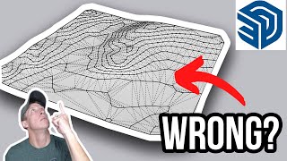
If you log into your account at maps.equatorstudios.com/, under the Data tab, select LiDAR and LiDAR-derived, and scroll to the second option which is Contours as DWG.


We are constantly making improvements to our user interface. If the UI in this video doesn't match the current UI of the Equator platform, watch our latest video on extracting data from Equator's newest interface: ruclips.net/video/Ogy6F-Fczac/видео.html
If you are having issues with your .dwg coming at the proper scale, try this: When you import a .dwg from Equator, prior to selecting "import" from the Import dialogue box, select Options (or Configure if you are using a Mac) and change your scale units from model units to the units your .dwg is in (either meters or feet).
Hmm I import the DWG in SKP but it doesn't read it, can't see the contours...
Hello! There wasn't a .dwg file option for download, only an .shp, .dxf., and .svg files.
If you log into your account at maps.equatorstudios.com/, under the Data tab, select LiDAR and LiDAR-derived, and scroll to the second option which is Contours as DWG.
@@equatorstudios that helped! Thank you!