How to Perform a Simple Spatial Data Analysis using QGIS

HTML-код
- Опубликовано: 4 окт 2024
- In this video, I demonstrated how to do a simple spatial data analysis/representation using different colours in QGIS. Please kindly subscribe to this channel and share the video with others.


![KSI - Thick Of It (feat. Trippie Redd) [Official Music Video]](http://i.ytimg.com/vi/At8v_Yc044Y/mqdefault.jpg)


All your Videos on QGIS has been of great help sir. Thank you so much. You're the best i have literally seen in learning QGIS
Am glad to help everyone understand how to use these GIS tools
Good work
I would love to learn from u virtually
Sure, we can arrange for that
Thanks a lot for this video! 🙂
Glad it was helpful!
Dear Dr.,
Could you give present how can we apply suitability analysis using qgis?
How to create a map which show the area suitable for two species A and B i mean the overlap area and the area only suitable for species A and or species B only and area not suitable for both species. you answer will be highly appreciated. tbanks
is there a way I could drop few areas for which I do not have any data.. I have 5 states out of which 2 are islands having no neighbours and 3 states have 1 or 2.
Thanks for imparting 🙏
My pleasure
Good morning, how to select 3-5 different countries to draw a single map?
It is very possible. You will have to select from the map of the world. Or u can get their separate shape files and combine together on the same interface
Sir.. how do I create a facilities map
thank you
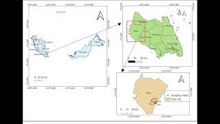
Dr. Festus please what is the source of your delta shapefile
I got it from diva GIS web. Check my video on creating study area map using QGIS...
Please can i get the previous class before this?
Pls check my channel for the videos
@@dr.festus354 please do you know how to design a fiber network FTTH using QGIS and can you train me?