Awesome video! I wanted to add that instead of dividing the amount of altitude you need to lose by 1000, and then multiply by 3, you could also just divide the amount of altitude needed to lose by 300!
I'm only a flight simmer but I'm constantly learning a little bit more than the day before. This video is brill and I'll be going through everything else you have! thanks!
Try the The rule of 3 & 6. In a piston a/c if you have 10000 ft to descend use 6x10 = 60 miles to get down. use 3 x you GS as you decent rate. In jets: if you want to descend 10000 ft use 3 x 10 = 30 miles to get down use 6 x your ground speed for you decent rate. It’s simple you can do it in head. Slowing down use 1 mile per 10 kts in level flight idle power.
well, if you dont have any GPS in your plane, you may also need to calculate the ground speed with an E6B before doing these calculations great video as always!
You can use ForeFlight to generate both a TOD waypoint and view a Descent to Destination (in feet per minute). The nice thing about this is that - if you’ve accurately entered your Performance information for your Aircraft, and planned your route - with older avionics stacks, you can get much the same info on ForeFlight. If, however, you just want to fly a general area and pick an airport to have lunch along the way (or get priority-diverted due to a family bathroom ‘emergency’), using Descent to Destination works extremely well. I’ve used it in both the 172 and the BL-17.
In the 530/430 there is a field you can put in the display called VSR (Vertical Speed Required) in connection with the VNAV function where you can input when you want to be at any altitude. It also works well when given clearances like "Cross 20 mi west of XXX at 8000". On that screen you have to put in your estimated/desired vertical speed, and it assumes the same groundspeed as in cruise, so you have to adjust for any speed increase in the descent. For example, I set it for 1200 fpm, knowing that I will actually descend at 1500 fpm. From that point it will give you time to TOD as well as an instantaneous readout of VSR, so you just need to match the numbers to hit your spot.
For a PA28-180, descending at cruise spd of 120kts, divide your descent 11,000' by 300, or, 110/3 = 36 nm. At cruise speed of 120kts, you'll need to descend ~600 fpm. My CFI said not to exceed 500-600 fpm for pax comfort, ears etc. What do you think of this method?
I live 12 miles away from our airport and aircraft that pass overhead are most usually I’m guessing 500’-1000’ up before landing. So they’ve made their descent long before.
Thank you for great formulas. Very very usefull when FMS profile calculation is inoperative ;))) So, taking into consideration that we fly JET with 400 knots ground speed at initial descent, our vertical will be 2000 feet per minute, arriving to the airfield within 200 knots we decrease it to 1000 to stay with our 3 degrees profile. Is it correct ?
I usually do similar to the second method. How much altitude will I need to lose? At a 500fpm decent (easier math than my usual 700fpm), how long will it take? Within 5 minutes of that time, start cruise descent.
Agree. I do the same. Easy to calculate in your head and ties to your speed, your aircraft. Plus a standard rate of descent (like climb) is more comfortable for your passengers and better for your engine. 500 fpm works great for me too.
0:50 doesn't work for 'any' aircraft. There are gliders that need a lot shallower descent than that. That approximation is like 1 to 20ish where as gliders need 1 to 50 and some 1 to 75. I can imagine helicopters and fighter jets as well as space shuttle and many other 'aircraft' need a different formula.
Do you have a video on the explanation of magnetic dips, variations, and turning errors? I understand course corrections but visualizing what a ‘magnetic compass will normally indicate a turn to the _____ when a ____ turn is entered from a _____ heading’ type questions are puzzling me..
We do have a great video on magnetic dip. Though it's not on the Channel, it's one of dozens of videos on the IFR ground school. Check it out at flight-insight.com/ifr
@@flightinsight9111 Ah thank you! I will be signing up for a few of your classes - dont tell John and Martha from King Schools that I'm cheating on them :(
I have a question. There doesn’t appear to be any factoring of earth curvature. I used all the numbers given and calculated that you would be 1200 feet higher than planned at the destination, since that would be the additional drop over 38 nautical miles.
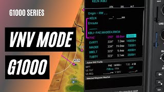
It seems I'm unable to enter altitude and offset in the g1000 nxi in MSFS2020. Does anybody know if this feature works similar to what the video shows at 04:59 ?
Is the G1000 you are using the Working Title version? Some of the things you are doing (changing Direct To ALT/offset, adjusting VNAV profile) don't seem to work for me.
Taboo Conspiracy is a liar and a con-man. Aircraft flying long distances or pretty much any distance at all plot their routes based on a globe. Their navigation systems are even based on one.
Loving your content! I have some calculations I made to explain the math for descents and CDI deflections, summarized in one image, that I would love to share - PM me if you want to see!
On behalf of every sane person on this globe, I feel truly sorry that your informative video has been twisted into proving that the Earth is flat, by some con-man.
@@flightinsight9111 Thank you for your reply, and video. But unfortunately people who think that the Earth is flat do not think, not logically at least. I am curious, does the curvature of the Earth matter during this type of approach? Or are the effects of it negligible?
@@aaallljjjj The altitude changes referenced in these calculations are based on "indicated altitude" read off the altimeter using changes in air pressure. While the curvature of the Earth requires us to lose more altitude than what the calculation shows, this is accounted for in our descent. Similar heights above the ground (regardless of the Earth's flatness or curvature!) have similar pressure, so we can ignore curvature and use the straight lines of trigonomtery to model the descent.
I googled it to double check and still am not sure (not a math genius). All I know is that calculating the cotangent of 3, then multiplying the opposite side gave me the correct result.
@@weiniesail Yes, arctan is for finding the angle. But he knows the angle: 3deg. He wants to find the length of the side adjacent to the angle. tan(3) = opp / adj adj * tan(3) = opp adj = opp / tan(3) adj = opp * cot(3) Ps - Best Flight school videos around. Thanks.


![Jack Harlow - Hello Miss Johnson [Official Music Video]](http://i.ytimg.com/vi/Q86_nlRoIGw/mqdefault.jpg)


Currently studying for my CFII. Finding your videos is like stumbling upon a gold mine. 100% the best instructional videos on youtube.
The guy is phenomenal
Doing the same thing , best of luck !
Awesome video! I wanted to add that instead of dividing the amount of altitude you need to lose by 1000, and then multiply by 3, you could also just divide the amount of altitude needed to lose by 300!
I'm only a flight simmer but I'm constantly learning a little bit more than the day before. This video is brill and I'll be going through everything else you have! thanks!
One of my favorite youtube aviation channels. Thanks for all your content. It provided for great learning.
Man literally I was just looking for this calculation and you uploaded thank you😂❤️
Same
Same
One of the best explanations ever
Try the The rule of 3 & 6. In a piston a/c if you have 10000 ft to descend use 6x10 = 60 miles to get down. use 3 x you GS as you decent rate. In jets: if you want to descend 10000 ft use 3 x 10 = 30 miles to get down use 6 x your ground speed for you decent rate. It’s simple you can do it in head. Slowing down use 1 mile per 10 kts in level flight idle power.
well, if you dont have any GPS in your plane, you may also need to calculate the ground speed with an E6B before doing these calculations
great video as always!
Or do everything in the time domain
You can use ForeFlight to generate both a TOD waypoint and view a Descent to Destination (in feet per minute).
The nice thing about this is that - if you’ve accurately entered your Performance information for your Aircraft, and planned your route - with older avionics stacks, you can get much the same info on ForeFlight.
If, however, you just want to fly a general area and pick an airport to have lunch along the way (or get priority-diverted due to a family bathroom ‘emergency’), using Descent to Destination works extremely well. I’ve used it in both the 172 and the BL-17.
Holy smokes this content is so good I feel like I’m stealing. You guys rule.
In the 530/430 there is a field you can put in the display called VSR (Vertical Speed Required) in connection with the VNAV function where you can input when you want to be at any altitude. It also works well when given clearances like "Cross 20 mi west of XXX at 8000". On that screen you have to put in your estimated/desired vertical speed, and it assumes the same groundspeed as in cruise, so you have to adjust for any speed increase in the descent. For example, I set it for 1200 fpm, knowing that I will actually descend at 1500 fpm. From that point it will give you time to TOD as well as an instantaneous readout of VSR, so you just need to match the numbers to hit your spot.
Super clear ! Well explained. Good job 👏🏻
For a PA28-180, descending at cruise spd of 120kts, divide your descent 11,000' by 300, or, 110/3 = 36 nm. At cruise speed of 120kts, you'll need to descend ~600 fpm. My CFI said not to exceed 500-600 fpm for pax comfort, ears etc. What do you think of this method?
I think you really made this more complicated than it needed to be. Even King Schools isn't this convoluted.
I've taken the King School ground school course for PPL, do they discuss TOD in their courses?
Gotta love these tips n tactics.
I live 12 miles away from our airport and aircraft that pass overhead are most usually I’m guessing 500’-1000’ up before landing. So they’ve made their descent long before.
Thank you for great formulas. Very very usefull when FMS profile calculation is inoperative ;))) So, taking into consideration that we fly JET with 400 knots ground speed at initial descent, our vertical will be 2000 feet per minute, arriving to the airfield within 200 knots we decrease it to 1000 to stay with our 3 degrees profile. Is it correct ?
Your vids prove the best!!
I usually do similar to the second method. How much altitude will I need to lose? At a 500fpm decent (easier math than my usual 700fpm), how long will it take? Within 5 minutes of that time, start cruise descent.
Agree. I do the same. Easy to calculate in your head and ties to your speed, your aircraft. Plus a standard rate of descent (like climb) is more comfortable for your passengers and better for your engine. 500 fpm works great for me too.
Hello, how do I calculate the fuel consumption for the descent?
0:50 doesn't work for 'any' aircraft. There are gliders that need a lot shallower descent than that. That approximation is like 1 to 20ish where as gliders need 1 to 50 and some 1 to 75.
I can imagine helicopters and fighter jets as well as space shuttle and many other 'aircraft' need a different formula.
How do you include the “curve” of the spinning globe in your calculation???
does the MFD automatically display the alt intercept arc or do you have to select that setting?
Great video
Thank you.
Do you have a video on the explanation of magnetic dips, variations, and turning errors? I understand course corrections but visualizing what a ‘magnetic compass will normally indicate a turn to the _____ when a ____ turn is entered from a _____ heading’ type questions are puzzling me..
We do have a great video on magnetic dip. Though it's not on the Channel, it's one of dozens of videos on the IFR ground school. Check it out at flight-insight.com/ifr
@@flightinsight9111 Ah thank you! I will be signing up for a few of your classes - dont tell John and Martha from King Schools that I'm cheating on them :(
I love you you make everything so do able
1:00 hahaha 😂Great video!
I have a question.
There doesn’t appear to be any factoring of earth curvature.
I used all the numbers given and calculated that you would be 1200 feet higher than planned at the destination, since that would be the additional drop over 38 nautical miles.
Is this the default G1000 functionality in the sim? I assume your using MSFS.
This is the Working TItle add-on for the G1000, excellent tool
It seems I'm unable to enter altitude and offset in the g1000 nxi in MSFS2020. Does anybody know if this feature works similar to what the video shows at 04:59 ?
Is the G1000 you are using the Working Title version? Some of the things you are doing (changing Direct To ALT/offset, adjusting VNAV profile) don't seem to work for me.
Looks like the video cut over to the G1000 trainer rather than the MSFS WT G1000 for that part of it.
Yes it's the Working TItle, with a cut to the Garmin PC trainer to show a function not available on the WT version
@@flightinsight9111 Hopefully when the the WT version becomes the default, they will those functions
Thanks! You proved flat earth with this video :)
You cant triogeometry with a curved surface as baseline :)
*use
*Trigonometry
ruclips.net/video/TFwPf9Cpz-A/видео.html
Taboo Conspiracy is a liar and a con-man. Aircraft flying long distances or pretty much any distance at all plot their routes based on a globe. Their navigation systems are even based on one.
Loving your content! I have some calculations I made to explain the math for descents and CDI deflections, summarized in one image, that I would love to share - PM me if you want to see!
On behalf of every sane person on this globe, I feel truly sorry that your informative video has been twisted into proving that the Earth is flat, by some con-man.
No worries! If it gets us thinking about trigonometry it's a win any day!
@@flightinsight9111 Thank you for your reply, and video. But unfortunately people who think that the Earth is flat do not think, not logically at least.
I am curious, does the curvature of the Earth matter during this type of approach? Or are the effects of it negligible?
@@aaallljjjj The altitude changes referenced in these calculations are based on "indicated altitude" read off the altimeter using changes in air pressure. While the curvature of the Earth requires us to lose more altitude than what the calculation shows, this is accounted for in our descent. Similar heights above the ground (regardless of the Earth's flatness or curvature!) have similar pressure, so we can ignore curvature and use the straight lines of trigonomtery to model the descent.
@@flightinsight9111 Thank you, once again for your answer! It helped clear up some things. :)
arc tangent not cotangent
No, cotangent is right.
I googled it to double check and still am not sure (not a math genius). All I know is that calculating the cotangent of 3, then multiplying the opposite side gave me the correct result.
@@flightinsight9111 cot(x)=1/tan(x)
if tan(x)=y, then arctan(y)=x
btw... just got my ifr rating last month. Loved all your videos and quizzes!
@@weiniesail Yes, arctan is for finding the angle. But he knows the angle: 3deg. He wants to find the length of the side adjacent to the angle.
tan(3) = opp / adj
adj * tan(3) = opp
adj = opp / tan(3)
adj = opp * cot(3)
Ps - Best Flight school videos around. Thanks.