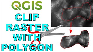
You selected the "Clipped (extent)" as the input layer instead of the "Merged" layer while clipping with the second method "Use Map Canvas Extent". That's why it didn't work out. Thank you for the well explained tutorial. You also showed where we could make mistake while clipping.


Thanks - this is great. It is actually useful that you make a mistake and leave it in - makes it more realistic!
Glad it was helpful!
You selected the "Clipped (extent)" as the input layer instead of the "Merged" layer while clipping with the second method "Use Map Canvas Extent". That's why it didn't work out. Thank you for the well explained tutorial. You also showed where we could make mistake while clipping.
i selected merged file it didnt clip still it came black what could be the reason?
whats a good way to get that DEM for a specific area?
Thank you so much, I'm working with climate data from wordclim and I really need it this.
You are welcome!
Thanks for this, very useful
You're welcome!
Great tutorial! How can we substitute SOME pixel values in Raster A with new updated values from Raster B?
You can do it with raster calculator. You'll just need a third raster to specify where you want to change the values.
@@geospatialschool Thanks. Are you planning to do a tutorial on that?
Thank you, this is really helpful. I am working with data from EEflux
But how do you also delete away the square from the original raster so it doesn't overlap?
Really good stuff
Glad you enjoyed
massive help
How do you clip based on grid (by polygon feature)?
I dont have the clipper option.
Am I the only one who constantly has problems when extracting? For me it doesn't work in like 80% of times
Q: Why are these types of programs (ArcGIS, QGIS) so convoluted? A: Because the programmers don't actually use the software.
And... thanks for the tutorial!