Be sure to LIKE and SUBSCRIBE. You can support my educational videos by clicking on the "Thanks" button just above (right of Like button) or by going here: www.paypal.com/donate/?hosted_button_id=EWUSLG3GBS5W8 or here: buymeacoffee.com/shawnwillsey
Thanks, Shawn. From the viewpoint of human lifetime, it's often hard to comprehend how much erosion goes on around us on a geological timescale. A shift of perspective is needed, and then we can be awestruck by the scale of things. This landscape is a beautiful example of erosion at work.
This 10-minute video is a perfect microcosm of your channel's philosophy and style. Observation, differentiated events, geologic classification, hypotheses framed by geologic processes (pressure and time -- erosive here), clear explanations and pleasingly informative diagrams. You know your audience and have facilitated the growth of a welcoming and curious community. Thank you Shawn.
Awesome. I'm from Montana but we used to have a place in St George. After seeing your video about the fault line to the east, I hoped you'd do Snow Canyon next! Any cyclists reading these comments need to visit this park. After a long climb up to the northern boundary you get to enjoy a fast, steep descent on a paved bike path along Hwy 18. St. George traffic is terrible but there are many bike paths that provide a safer way to enjoy long, scenic rides.
Great video Shawn. At the start I thought you were maybe going to describe some sort of magma dike being injected underneath an older layer, but I'd say the different lava flows still follow the superposition rule here. Each flow is still being extruded and layered over the older sandstone rocks, even if the elevations of the newer flows are lower in this landscape.
Thank you for these videos Mr. Willsey. I moved to St. George in 2017. The surrounding landscape is very dramatic and a far cry from the flat swamplands of Florida. Your videos have taught me so much and helped me understand the geological history of this region. The first video of yours that I watched was a random roadcut you did along I-15 explaining the lava flow cap on the Navaho Sandstone. That video sparked a learning adventure that I anticipate having no end. Thanks again. Many thanks!
Wow, that first one you watched is an old one. Way to stick with me this long. Glad you are enjoying these. Look for a few more STG area videos that I recorded around Christmas time.
I tell you what man... I've learned a lot from watching your videos, and those from Nick, and Myron Cook... But I still feel like a clutz with this stuff when I walk out my door and see the redish shale that covers everything in my area and have no idea what I'm looking at. But I got this one... I figured it out right away, but only because you dated those lava flows, as I couldn't have figured it out otherwise... There's a learning curve. As with so many other things, there's just a lot to it. So... I thank you for being one of the small number of precious, prominent and professional voices in my geology studies. Peace.
Such raw beauty in this landscape! I want to grab my sketchbook and pens and capture some of this while I listen. Thank you for sharing and sneaking in your teaching while we are mesmerized by both the sight and the words. I'm hooked!
One more location added to my places to visit list. This is a more complex example of inverted topography than the long familiar Wright’s Point south of Burns, OR, a textbook example one crosses traveling from Burns to Frenchglen.
I live 5 minutes away from Snow Canyon. I ride or hike this canyon multiple times weakly. I have seen Snow Canyon when the low clouds flow thru here and its absolutely beautiful. I’ve been here when it’s rained for days and there are waterfalls everywhere. My home is surrounded by lava flows.
A magnificent example of inverted topography can be seen on Hwy 108 near the town of Jamestown in California. 10 million year old lava, which had flown down an ancient river valley, are now the highest point in the landscape. From the air, the curving path of the old river can clearly be seen.
Hello Shawn and greetings from Kanab Utah ... It would be unfortunate if this region becomes volcanicaly active again! Thank you for all your efforts in bringing your knowledge of geology to soo many of us. Respectfully, Utah Mike. 🤩👍
Thanks Shawn! I always love your videos and educating information and love learning more and more about Geology and our planet all together. Thank You. I am supporter too. Peace.
Great video Shawn, clear, concise, visually pleasing and informative. I've been there many times. My old high school buddy lives maybe five to ten miles from that spot in a small community just north called Dammeron Valley.
This country is a thrill to see. Your sketches are perfect at explaining! It's definitely something new to consider and brings up more questions. I'll do some reading and get back to you. 😉 I love your teaching moments!
Thank-you once again, DrShawn. Your succinct & informative presentations have taught me &, no doubt, so many others so much about geology. What a gift you give. Thanks again.
What a beautiful location! Here I was trying to guess something complex. This is a good reminder to me that it can be and often is a basic erosion story. Basics are so important and must not be forgotten. During your sabbatical you have greatly expanded my geology experience beyond places I have traveled. I'm very glad because I'm discovering so many new to me beautiful and fascinating places. You are creating wonderful tools for use with your future in person classes. Plus so many people not taking in person classes are gaining wonderful learning from fun videos.
I was curious about where that lava came from. I just went to Google Earth of the area and found up the canyon is the Santa Clara Volcano. And looking at the topography of the canyon you can see how those layers formed and see how the erosion of the red Navajo Sandstone that led to the next layer of lava's path down that canyon as you pointed out. Fascinating! I got to do some geology and didn't have to leave my house! Although, I admit, being there would be more fun.
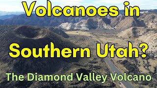
Radiometric dating of older flows. Younger ones dated with carbon-14 and charcoal deposits found in flows. Sandstone dated using index fossils. Lava comes from vents to the north.
Thanks for replying Professor, I'm assuming that all the sandstone and other sedimentary rocks in the southwest are from ancient sea deposits, what is the age range? @@shawnwillsey
Very scenic valley there, esp to the south! I believe Table Mtn on the west edge of the Sierra not far from Sacramento is another example of this inverted landscape type, with a lava flow from the east of the Sierra crest (the range was lower) flowing to the west dozens of miles. So in present day we now have this mesa mountain with a cap of basalt, and erosion has lowered the land to the sides.
Thanks again Shawn, I was able to figure it out, kind of similar to what it looks like at Table Mtn by Oroville Calif. I like your videos, good editing, tidy job!! :-)
I see the older lava is higher than the younger but I they're not actually on top of each other physically. They're indifferent areas areas so to me it makes😊 sense
Thanks Shawn. I checked out the area on Google Earth. You can see the different lava flows, the patterns and age of each each flow based upon lighter color with age due to sand infill, and 2 small cones that appear to be associated the newest flows. The oldest flow is much larger.
PS: For cyclic eruptions in the same plane (like the current Iceland eruptions an older field layer is (almost always) lower than a newer layer. The sequence of layers at any site can vary in the omissions compared to distant sites in the flows. Nearby sites will usually show the same sequence. The exceptions are lava tunnels where newer lava can be found under older lava if the tunnel is reused by a newer flow. In Utah the patterns were in large part determined by the patterns of erosion in the sandstone between eruptions. In Iceland the flow is usually determined by the current topography and the underlying plumbing
Thoroughly enjoying learning geology with you! If the source of the eruptions is the same, shouldn't there be a location nearer to the source that has lava flows in the normal order because they'd be on top of one another?
Interesting. I would have guessed either this or upthrust. While this was clear, I find myself still curious about the following: - How old is the Navajo Sandstone? - I'm guessing the Navajo Sandstone was the old sea bed? - When did the sandstone get raised from the sea bed to the current elevation? Clearly longer than 1.4Myo
Thanks for teaching me something new today! I think that Utah is a beautiful state. So many beautiful places to see! Question, Have you ever been to The Valley of Fire in Nevada? It has some incredible geology. If you haven't been there, you definitely need to see this place!
That was a neat little mystery. I was thinking some kind of subsidence so no, I didn't guess the real reason. That was fun though trying to figure it out.
The theory of superpositioning works great when the rocks are stacked on top of each other. A perfect example of this is the Snake River plain basalts there are thousands of feet thick stacked on top of one another
Would love to have you do this type of video in the volcanic areas of Northern Arizona. There's a lava tube you can walk in, sunset crater, and of course the peaks (volcanoes) around Flagstaff. There should be some good hiking & rock climbing around for you, too. :-)
How about this? ruclips.net/video/s-z2-dBFoDI/видео.htmlfeature=shared Northern Arizona does indeed have great geology. I went to NAU for grad school and know the area well.
Thanks-I had thought maybe massive intrusions from beneath but of course Geology is really about deep time so my thought did not include enough patience-
I have several from that area: ruclips.net/video/fJpBUo8rAjc/видео.html ruclips.net/video/ZchyJV_twv8/видео.html And more under this playlist: ruclips.net/p/PLOf4plee9UzCdJ19lPAlc5tVCZ22C703h
😁 Thx for the great video, Shawn! I have a question... Does this area share/overlap space between the Colorado plateau and the Basin & Range? It seems that way on satellite Google maps view... 🤔
@@shawnwillsey 😊thank you much! Your videos are invaluable to my geologic curiosity. They create perspective I wouldn't otherwise have. I'm learning a lot. 😊
it looks like there’s erosion of the sandstones along the edge of the youngest lava flow way in the west of the view you showed us. But why is it called Snow canyon?
Smarty pants. I'll just keep listening. Eventually I'll get it. I think this stuff is very relevant to know as volcanism and earthquakes start to increase.
Again, more than a touch of envy that you can just drive up there, park up and walk about in this fabulous landscape - here in the U.K. someone would have put a fence around it, some KEEP OUT signs or a little booth to pay entrance fees.
As a geological layman, how could I find out the ages of rock I was looking at without digging (pun intended) into the geological literature? Is there a website that provides the ages of exposed rock for different areas of the country or would I have to get geology books on that area or ask a friendly local geologist? Great video and thanks!
QUESTION - Thank you for all your videos - we watch all the time - here is my question - the different lava flows makes total sense. Where was the volcano located that erupted? North? Thanks.
Maybe I lived in Nevada too long - was there not any kind of pulling apart? I mean to the right I do see what looks like the markers of erosion, but to the left where the two layers of sandstone are visible, it looks more like the valley floor dropped down than was eroded out. I was thinking it was more separation than erosion (and I'm not a geologist or a geology student, I just want to know the stories the rocks are telling.)
This is very informative and interesting! But would you please keep your camera steady, mount it on some kind of tripod? The constant moving of it is not comfortable to watch.
It has to do with Graben Horst terrain doesn't it? At least the uplift component boosting erosion and providing the lava via extension. I knew about inverted topography but I'm ashamed to say that slipped my mind at the time, though in my defense you hadn't gotten to the part of the video where you explain there are no faults in this general area between these flows and the canyon. Faulting is my default guess in a mountainous area to get inverted terrain layers at least barring something absolutely crazy like the Heart mountain slide which Myron Cook brought to my attention. Off way in the distance on the other side of the canyon is that yet another ancient lava flow?
My (totally uneducated) first guess would have been Basin & Range extension causing a series of grabens, the lava flowing into what was the lowest at the time. When you look at the landscape, what are you seeing that rules this out? Thanks.
the 1,1 million to 20,000 years gap made me get the answer, because I thought oh wait that's a long time, I bet a lot of erosion can happen in one million years... So the next eruption can flow in a lower spot. The most important piece of the puzzle is the realization that these basalt stone layers are not exactly on TOP of each other, but rather like a staircase next to each other
I mean aside from the anomalous deposition of said lava, it does reinforce the fact that states outside of the larger volcanic zones (cascades arc etc) are still, and should be considered, volcanically active. 20,000 years isn't enough time to consider a volcanic field extinct..
The word "superposition" has been hijacked by the quantum mechanics crowd and now means something else (which I,admittedly, don't get). The time scale involved suggests ice age floods may have carved the valley. Were the two older flows at their terminus or were they originally more expansive and partially eroded away.


Be sure to LIKE and SUBSCRIBE. You can support my educational videos by clicking on the "Thanks" button just above (right of Like button) or by going here: www.paypal.com/donate/?hosted_button_id=EWUSLG3GBS5W8
or here: buymeacoffee.com/shawnwillsey
Thanks, Shawn. From the viewpoint of human lifetime, it's often hard to comprehend how much erosion goes on around us on a geological timescale. A shift of perspective is needed, and then we can be awestruck by the scale of things. This landscape is a beautiful example of erosion at work.
This 10-minute video is a perfect microcosm of your channel's philosophy and style. Observation, differentiated events, geologic classification, hypotheses framed by geologic processes (pressure and time -- erosive here), clear explanations and pleasingly informative diagrams. You know your audience and have facilitated the growth of a welcoming and curious community. Thank you Shawn.
Great cmt @David.
Well said. ✌🏻
Yes, couldn't have said it better!
Absolutely!
Love that spot! You do such a wonderful job of interpretation. Really makes it easily digestible. Thank you, as always!
Awesome. I'm from Montana but we used to have a place in St George. After seeing your video about the fault line to the east, I hoped you'd do Snow Canyon next! Any cyclists reading these comments need to visit this park. After a long climb up to the northern boundary you get to enjoy a fast, steep descent on a paved bike path along Hwy 18. St. George traffic is terrible but there are many bike paths that provide a safer way to enjoy long, scenic rides.
So much fun. I am going sound like a rock master when I explain it to the grandchildren 😊
Thanks! Wonderful class on interesting SW Utah topography!
Much appreciated. Thanks for your kind donation toward geology education videos.
Great video Shawn. At the start I thought you were maybe going to describe some sort of magma dike being injected underneath an older layer, but I'd say the different lava flows still follow the superposition rule here. Each flow is still being extruded and layered over the older sandstone rocks, even if the elevations of the newer flows are lower in this landscape.
Thank you for these videos Mr. Willsey. I moved to St. George in 2017. The surrounding landscape is very dramatic and a far cry from the flat swamplands of Florida. Your videos have taught me so much and helped me understand the geological history of this region. The first video of yours that I watched was a random roadcut you did along I-15 explaining the lava flow cap on the Navaho Sandstone. That video sparked a learning adventure that I anticipate having no end. Thanks again. Many thanks!
Wow, that first one you watched is an old one. Way to stick with me this long. Glad you are enjoying these. Look for a few more STG area videos that I recorded around Christmas time.
I tell you what man... I've learned a lot from watching your videos, and those from Nick, and Myron Cook... But I still feel like a clutz with this stuff when I walk out my door and see the redish shale that covers everything in my area and have no idea what I'm looking at.
But I got this one... I figured it out right away, but only because you dated those lava flows, as I couldn't have figured it out otherwise...
There's a learning curve. As with so many other things, there's just a lot to it.
So... I thank you for being one of the small number of precious, prominent and professional voices in my geology studies.
Peace.
Such raw beauty in this landscape! I want to grab my sketchbook and pens and capture some of this while I listen. Thank you for sharing and sneaking in your teaching while we are mesmerized by both the sight and the words. I'm hooked!
One more location added to my places to visit list. This is a more complex example of inverted topography than the long familiar Wright’s Point south of Burns, OR, a textbook example one crosses traveling from Burns to Frenchglen.
Thanks!
I appreciate your kind donation toward my geology videos.
Thx Shawn for breaking down the processes that formed this landscape...
I live 5 minutes away from Snow Canyon. I ride or hike this canyon multiple times weakly. I have seen Snow Canyon when the low clouds flow thru here and its absolutely beautiful. I’ve been here when it’s rained for days and there are waterfalls everywhere. My home is surrounded by lava flows.
@copi..... funny how spell ck chgd your cmt from Ride Weekly to Ride Weakly. Or was weakly intentional on your part? lol ✌🏻thx for the laugh.
We own 1.5 acres north of Veyo and also 5 min from Snow Canyon that we hope to build on someday. I love the geology and recreation of this area.
Thanks again Shawn! I love rocks that tells us these stories.
A magnificent example of inverted topography can be seen on Hwy 108 near the town of Jamestown in California. 10 million year old lava, which had flown down an ancient river valley, are now the highest point in the landscape. From the air, the curving path of the old river can clearly be seen.
Hello Shawn and greetings from Kanab Utah ... It would be unfortunate if this region becomes volcanicaly active again! Thank you for all your efforts in bringing your knowledge of geology to soo many of us. Respectfully, Utah Mike. 🤩👍
Thanks Shawn! I always love your videos and educating information and love learning more and more about Geology and our planet all together. Thank You. I am supporter too. Peace.
Great video Shawn, clear, concise, visually pleasing and informative. I've been there many times. My old high school buddy lives maybe five to ten miles from that spot in a small community just north called Dammeron Valley.
Beautiful location. Thanks Professor, i was scratching my head till you produced one of your great drawings. 👍👍👍
Thanks
Thank you for the donation toward geology education videos.
I've learned a lot from watching your videos, especially videos like this one, they're short and clear. Keep up the good work & thank you Shawn !!
Absolutely fantastic information’ great easy explanation.
Great video Shawn. Thank you for posting it.
Great to watch. Thanks Shawn.
This country is a thrill to see. Your sketches are perfect at explaining! It's definitely something new to consider and brings up more questions. I'll do some reading and get back to you. 😉 I love your teaching moments!
Love this lesson!
Nice 👍. A few of your vlogs and I’m really understanding what I’m looking at ! Fun !
Thank-you once again, DrShawn. Your succinct & informative presentations have taught me &, no doubt, so many others so much about geology. What a gift you give. Thanks again.
I haven’t heard of, nor been to Snow Canyon SP. It looks like a place that I would like to visit.
Thanks.
Thank you Shawn!! 🙏
I really appreciate your efforts
What a beautiful location! Here I was trying to guess something complex. This is a good reminder to me that it can be and often is a basic erosion story. Basics are so important and must not be forgotten. During your sabbatical you have greatly expanded my geology experience beyond places I have traveled. I'm very glad because I'm discovering so many new to me beautiful and fascinating places. You are creating wonderful tools for use with your future in person classes. Plus so many people not taking in person classes are gaining wonderful learning from fun videos.
I was curious about where that lava came from. I just went to Google Earth of the area and found up the canyon is the Santa Clara Volcano. And looking at the topography of the canyon you can see how those layers formed and see how the erosion of the red Navajo Sandstone that led to the next layer of lava's path down that canyon as you pointed out. Fascinating! I got to do some geology and didn't have to leave my house! Although, I admit, being there would be more fun.
I was wondering where the lava came from myself.
Fascinating! Thanks so much. Made me smile.
Thank you for the informative history lesson. Earth sure is a mystery with many secrets waiting to be discovered!
How was the basalt dated? How old are the layers of sandstone? Where was the source of the lava?
Radiometric dating of older flows. Younger ones dated with carbon-14 and charcoal deposits found in flows. Sandstone dated using index fossils. Lava comes from vents to the north.
Thanks for replying Professor, I'm assuming that all the sandstone and other sedimentary rocks in the southwest are from ancient sea deposits, what is the age range? @@shawnwillsey
Thank you Shawn 😊 very interesting 👍 😊
It's amazing how much the Earth changes over time.
Thank you.
wow. pretty kewl. makes so much sense. geology is so not boring at all :)
Thx Prof. ✌🏻 fascinating geo-ed adventure.
This was very interesting, I feel like I learned something today.
Well done!
Great info! Thanks
I think a similar dynamic played out on the South Fork of the Boise River canyon.
Well done, I learned something.
In addition the south end seems to be pushed up (as evidenced in the layers of sandstone) also adding elevation to the older flow.
I'll keep a better eye at my next hike on the Canary islands volcanoes, ie Teide volcano on Tenerife island, thanks for the simple explanation!
Very scenic valley there, esp to the south! I believe Table Mtn on the west edge of the Sierra not far from Sacramento is another example of this inverted landscape type, with a lava flow from the east of the Sierra crest (the range was lower) flowing to the west dozens of miles. So in present day we now have this mesa mountain with a cap of basalt, and erosion has lowered the land to the sides.
Thanks again Shawn, I was able to figure it out, kind of similar to what it looks like at Table Mtn by Oroville Calif. I like your videos, good editing, tidy job!! :-)
Another interesting video!
I see the older lava is higher than the younger but I they're not actually on top of each other physically. They're indifferent areas areas so to me it makes😊 sense
Thanks Shawn. I checked out the area on Google Earth. You can see the different lava flows, the patterns and age of each each flow based upon lighter color with age due to sand infill, and 2 small cones that appear to be associated the newest flows. The oldest flow is much larger.
PS: For cyclic eruptions in the same plane (like the current Iceland eruptions an older field layer is (almost always) lower than a newer layer. The sequence of layers at any site can vary in the omissions compared to distant sites in the flows. Nearby sites will usually show the same sequence. The exceptions are lava tunnels where newer lava can be found under older lava if the tunnel is reused by a newer flow.
In Utah the patterns were in large part determined by the patterns of erosion in the sandstone between eruptions. In Iceland the flow is usually determined by the current topography and the underlying plumbing
Love your videos, I sort of guessed it had something to do with erosion. Very interesting
I love your intro by the way, especially the knocks with the hammer. 😊
Thanks. My wife put that together. I'll pass this along.
@@shawnwillsey Please tell your wife that it’s great. The music is soothing and then the three hammer knocks to wake us up. 😊
Reminds me of a gavel, presiding over geological court.
@@markcollins3418 Brilliant!
Great explanation! Thanks. Q: what happened to the huge amount of sandstone mass that was eroded away?
I recognized those plateaus as soon as I saw the thumbnail!
The GPS location seems to point to Zhengguo China on Google Earth, just saying. Thanks for all the great videos.
Small mistake. Needed a "-" sign in front of longitude. Fixed now.
Thoroughly enjoying learning geology with you! If the source of the eruptions is the same, shouldn't there be a location nearer to the source that has lava flows in the normal order because they'd be on top of one another?
Interesting. I would have guessed either this or upthrust.
While this was clear, I find myself still curious about the following:
- How old is the Navajo Sandstone?
- I'm guessing the Navajo Sandstone was the old sea bed?
- When did the sandstone get raised from the sea bed to the current elevation? Clearly longer than 1.4Myo
Navajo Sandstone is Jurassic in age (about 200 million years old)
@@shawnwillsey Thanks. Was it the old sea bed? And when was it upthrust to the current elevation?
Shawn, this is fascinating. How quickly--or slowly--does erosion occur in sandstone? Is it measureable? If so, can you give us details?
You rock!
Thanks for teaching me something new today! I think that Utah is a beautiful state. So many beautiful places to see!
Question, Have you ever been to The Valley of Fire in Nevada? It has some incredible geology. If you haven't been there, you definitely need to see this place!
Yes, another great place. Same sandstone as Zion and Snow Canyon.
Nice info, thanks. Question, where did the Lavas/Basalt come from in that area? And possibly why?
Just to the north. Look for a future video that explores a fantastic volcano nearby.
That was a neat little mystery. I was thinking some kind of subsidence so no, I didn't guess the real reason. That was fun though trying to figure it out.
The theory of superpositioning works great when the rocks are stacked on top of each other. A perfect example of this is the Snake River plain basalts there are thousands of feet thick stacked on top of one another
Well sort of. Lava flows don't always follow these rules perfectly. But in general, this is true.
Shawn I think you need a Quadcopter for aerial photos that you can edit into your commentary.
At Coffeepot crater, you can see 1000-year-old pahoehoe lava that pooled and solidified below a scarp of 13-million-old lava.
Would love to have you do this type of video in the volcanic areas of Northern Arizona. There's a lava tube you can walk in, sunset crater, and of course the peaks (volcanoes) around Flagstaff. There should be some good hiking & rock climbing around for you, too. :-)
How about this?
ruclips.net/video/s-z2-dBFoDI/видео.htmlfeature=shared
Northern Arizona does indeed have great geology. I went to NAU for grad school and know the area well.
With repeated lava flows I was thinking active region and my mind went to a graben. But erosion works as well, of course.
Cool!
Thanks-I had thought maybe massive intrusions from beneath but of course Geology is really about deep time so my thought did not include enough patience-
I would love to see a lesson on the Owens Valley in California
I have several from that area: ruclips.net/video/fJpBUo8rAjc/видео.html
ruclips.net/video/ZchyJV_twv8/видео.html
And more under this playlist: ruclips.net/p/PLOf4plee9UzCdJ19lPAlc5tVCZ22C703h
Where was the volcanic vent located that created these basalt cliffs?
😁 Thx for the great video, Shawn!
I have a question... Does this area share/overlap space between the Colorado plateau and the Basin & Range? It seems that way on satellite Google maps view... 🤔
Yes, this is the transition zone between the two provinces.
@@shawnwillsey 😊thank you much! Your videos are invaluable to my geologic curiosity. They create perspective I wouldn't otherwise have. I'm learning a lot. 😊
it looks like there’s erosion of the sandstones along the edge of the youngest lava flow way in the west of the view you showed us. But why is it called Snow canyon?
Named after early Mormon settlers of the area, Lorenzo and Erastus Snow.
Where did the basalt flow originate from?
Just to north are vents. Featured in an upcoming video.
Watching Nick Zentner’s videos clued me into that being the likely solution.
Smarty pants. I'll just keep listening. Eventually I'll get it. I think this stuff is very relevant to know as volcanism and earthquakes start to increase.
❤❤❤❤❤
Again, more than a touch of envy that you can just drive up there, park up and walk about in this fabulous landscape - here in the U.K. someone would have put a fence around it, some KEEP OUT signs or a little booth to pay entrance fees.
As a geological layman, how could I find out the ages of rock I was looking at without digging (pun intended) into the geological literature? Is there a website that provides the ages of exposed rock for different areas of the country or would I have to get geology books on that area or ask a friendly local geologist? Great video and thanks!
Learn to read geologic maps which include ages of geologic units. Hope to do a video on this soon.
thanks, a google search shows that they are available at USGS and Colorado geological survey.@@shawnwillsey
It seems so obvious once you explained it, but my first guess was a major flood. Shows you why I'm not a geologist.
QUESTION - Thank you for all your videos - we watch all the time - here is my question - the different lava flows makes total sense. Where was the volcano located that erupted? North? Thanks.
Yes, vents are to the north and lava flowed mainly south. Look for future video that showcases the youngest vent and a nice volcano.
Is there a river running through there now?
No permanent streams here.
Are all of the elevation changes due to erosion, or is this valley a graben?
Mainly erosion.
@@shawnwillsey Thanks!
Maybe I lived in Nevada too long - was there not any kind of pulling apart? I mean to the right I do see what looks like the markers of erosion, but to the left where the two layers of sandstone are visible, it looks more like the valley floor dropped down than was eroded out. I was thinking it was more separation than erosion (and I'm not a geologist or a geology student, I just want to know the stories the rocks are telling.)
might be a simple erosion (river make canyon then lava flows into that canyon)
oh, i got it right (i was halfway watching video when make first comment), now i hope for a prize🤣🤣🤣
@@leafeon_gtr9223 no prize, but I'll give you a 👍
This is very informative and interesting! But would you please keep your camera steady, mount it on some kind of tripod? The constant moving of it is not comfortable to watch.
How are you in so many places all the time? I want to do that.
This was taped around Christmas time. Videos are backlogged at moment so the order they are posted does not reflect my whereabouts at that time.
It has to do with Graben Horst terrain doesn't it? At least the uplift component boosting erosion and providing the lava via extension. I knew about inverted topography but I'm ashamed to say that slipped my mind at the time, though in my defense you hadn't gotten to the part of the video where you explain there are no faults in this general area between these flows and the canyon. Faulting is my default guess in a mountainous area to get inverted terrain layers at least barring something absolutely crazy like the Heart mountain slide which Myron Cook brought to my attention.
Off way in the distance on the other side of the canyon is that yet another ancient lava flow?
The word I’m looking at is Graben
My (totally uneducated) first guess would have been Basin & Range extension causing a series of grabens, the lava flowing into what was the lowest at the time. When you look at the landscape, what are you seeing that rules this out? Thanks.
if you know the rather obscure word 'graben' you are certainly not 'totally uneducated' :D
Shawn never mentioned faults.
the 1,1 million to 20,000 years gap made me get the answer, because I thought oh wait that's a long time, I bet a lot of erosion can happen in one million years... So the next eruption can flow in a lower spot. The most important piece of the puzzle is the realization that these basalt stone layers are not exactly on TOP of each other, but rather like a staircase next to each other
👍
To me I would look at Grindavik Iceland, If the land is sinking, It is sinking, where the land is rising due to a temporary rift!!!
it is a pity that in Holland the volcanoes are in the Wadden Sea and are 160 million years old and covered withe sand and water
I mean aside from the anomalous deposition of said lava, it does reinforce the fact that states outside of the larger volcanic zones (cascades arc etc) are still, and should be considered, volcanically active. 20,000 years isn't enough time to consider a volcanic field extinct..
The word "superposition" has been hijacked by the quantum mechanics crowd and now means something else (which I,admittedly, don't get). The time scale involved suggests ice age floods may have carved the valley. Were the two older flows at their terminus or were they originally more expansive and partially eroded away.