Размер видео: 1280 X 720853 X 480640 X 360
Показать панель управления
Автовоспроизведение
Автоповтор
Very impressive! :D
What 3D point algorithm did you use?
Is it using IR or ultrasound? Can i get a link with the sensors it is using? Thank you
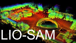
Its a VLP-16 laser scanner
@@PinguiniAlfredo thank you very much
That's so cool
is it expensive ? It could be combined with the SLAM
what do you mean combined with SLAM? This is literally SLAM, isn't it?
Where can we buy these in Canada
How is this going?
is this underground?
Obviously no. Those are trees.
@@inglam 🤣
Panner Selvam..... dharmapuri


Very impressive! :D
What 3D point algorithm did you use?
Is it using IR or ultrasound? Can i get a link with the sensors it is using? Thank you
Its a VLP-16 laser scanner
@@PinguiniAlfredo thank you very much
That's so cool
is it expensive ? It could be combined with the SLAM
what do you mean combined with SLAM? This is literally SLAM, isn't it?
Where can we buy these in Canada
How is this going?
is this underground?
Obviously no. Those are trees.
@@inglam 🤣
Panner Selvam..... dharmapuri