What a blessing l found this. The plat map for the land I am buying has contour lines showing a steep grade in back of the neighboring lot. But not mine. What a relief. I can rest assured I have a liveable backyard now.
Excellent review video on Topographic maps and the rules to follow. Two comments: First, as Coda8566 mentioned, the first practice question answer should be choice D. 561-569 not B , if you count the circle around the "*" as 560. Second, I am not convinced the lake shoreline is EXACTLY 460. I think this is an assumption on Ms. Kidder's part. I see it as LESS than 470 feet but greater than 460 feet.
I've just started on agtek earth work takeoff and sometimes I don't get all of the contour lines elevation and sometimes it was harder to determine whether it es going up or down , thanks for the insights
Holland Hill. IS 560!!!! THE * is the position "your at"..... meaning the circle around.it.IS a Contour Line...... The Elevation you seek IS 560! Attention to Detail is all. Just as Aurora Hill w the Triangle is also w in the top Contour at 533 hill top.
She got the first question wrong. It's D, there is another contour line for 560ft she traced over it when she was identifing the star (the star is in the middle of the 560ft contour line).
@@coda8566 It looked like a contour line to me also if it was a circle around the point it should be a different color i would've missed the question too
Watching this for the first time and I have to agree with you Coda8566. Ms. Kidder even said if it was 560 there would be another circle around the star. WELL there IS!!! So I would count that as 560, so the "*" would be 561-569.


Excellent teaching. Currently doing some geology and this explains it much easier for me. Thanks much.
Excellent presentation which is easily understood by a person new to the subject
.Thanks
IK
Nice, simple and straight to the point
What a blessing l found this. The plat map for the land I am buying has contour lines showing a steep grade in back of the neighboring lot. But not mine. What a relief. I can rest assured I have a liveable backyard now.
This girl just explained better than my teacher
I bet she's older than your mama for being called a girl.
same here.
onggg!
Your not funny
This helped me A LOT! Thank you!
Excellent review video on Topographic maps and the rules to follow. Two comments: First, as Coda8566 mentioned, the first practice question answer should be choice D. 561-569 not B , if you count the circle around the "*" as 560. Second, I am not convinced the lake shoreline is EXACTLY 460. I think this is an assumption on Ms. Kidder's part. I see it as LESS than 470 feet but greater than 460 feet.
I've just started on agtek earth work takeoff and sometimes I don't get all of the contour lines elevation and sometimes it was harder to determine whether it es going up or down , thanks for the insights
You are amazing, very clear!
this was a great refresher mam thank you so much!
Simply superb 👌 explanation mam thank you
Thank for your explanation, but my concern have to do with,why the contour lines never cross or intersect each other?
Great presentation; easily understood. Thank you so much.
Holland Hill. IS 560!!!!
THE * is the position "your at"..... meaning the circle around.it.IS a Contour Line...... The Elevation you seek IS 560!
Attention to Detail is all.
Just as Aurora Hill w the Triangle is also w in the top Contour at 533 hill top.
She got the first question wrong. It's D, there is another contour line for 560ft she traced over it when she was identifing the star (the star is in the middle of the 560ft contour line).
R you dum or stupid, no it isn't , its not suppose to be 560
Well what's the circle around the star then?
@@coda8566 It looked like a contour line to me also if it was a circle around the point it should be a different color i would've missed the question too
Watching this for the first time and I have to agree with you Coda8566. Ms. Kidder even said if it was 560 there would be another circle around the star. WELL there IS!!! So I would count that as 560, so the "*" would be 561-569.
Does anyone know what a contour interval line is
Thanks for the help! I now understand 🙂👍
Thanks for the explanation.
This really help a lot. thank you for sharing.
What if there is a question on how to find the interval for the topograpic map that you can see?
First question is D to my interpretation of the map. But in all a great video. I learnt a lot thanks.
Yep. The asterisk is surrounded by the 560 contour
The first question is choice D
Would like to see many more of her videos
IK
How to draw contours using surfer 8
ruclips.net/video/sZYmx-XV_n4/видео.html
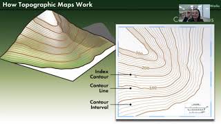
This is Ashley Bryant. I learned that contour maps show changes in elevation.
great video😊 ty
GOOD ONE RENE
Great, thank you, helped a lot.
Nice very excited
Super informative video regarding contour map, thnx pretty Rene Kidder :)
Thanks so much, helps alot , my teacher doesn't really know how to explain
Thank you. You are awesome
we learnt these concepts at a technical vocational school and I just want to know what are the benefits of studying about them in this current state
Very helpful ❤️
perfect thank you❤
It really helped me to understand but I dont know that I can do this in my exam or not
Do you have a student worksheet available for this?
Thanks
Thanks would have failed without you
What is the elevation of the index contour line?
Thank you so much
this really helps
A. Dean GOL105V1SU24
This was super helpful, thank you.
this helped a lot
Thank you
Is this possible to use the compass on the topography map?
Geography exam tomorrow, very desperate 😂
Same bro 😂
@@Regnaild I have stopped taking Geography now
really helpful
👍
Thanks mam
👏🏽👏🏽👏🏽
Really? if you saw this map in 15 years lol
mam how to find Ridge line in contour map? please explain
Trilingler??
500ft above what? Sea level or that lake?
Mum please 500 for Y but 590 and wrote 520 for z
define contour lines
Please*
10 Q so much
7:25 I thought that asterisk is surrounded by a contour line i.e. thatd make it 561 569. I does look like another contour. anyway...
"If you look really, really careful..." should be: "if you look really, really carefulLY..."
Apparently you missed that English class.
chill
0:00