How to Process Drone Images in Agisoft Metashape Without GCPs

HTML-код
- Опубликовано: 29 авг 2024
- Welcome to geomatics Engineering Nepal
In this video, you'll learn:
How to import and organize your drone-captured images in Agisoft Metashape.
The best practices for aligning images to ensure accuracy.
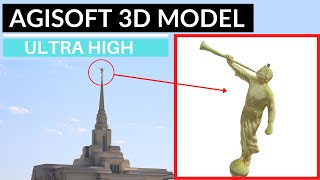
Techniques for building dense point clouds, mesh models, and textured models.
Tips for generating high-quality orthomosaics and DEMs (Digital Elevation Models).
Common pitfalls to avoid and troubleshooting tips to optimize your results.
Join us as we navigate through the entire process, providing you with valuable insights and practical advice to make the most of your drone imagery. Don't forget to like, comment, and subscribe for more tutorials on Agisoft Metashape and other geospatial software.
Links & Resources:
Agisoft Metashape Official Website
Drone Photography Tips
Join our Geospatial Community


Great video, can you guide me on how to create a flight plan for Phatom 4, thank you very much