Hiking off-trail Minaret Lake to Iceberg Lake Cross Country Route in the Ansel Adams Wilderness

HTML-код
- Опубликовано: 6 сен 2024
- Link to full length video here: • Backpacking The High S... ...This is an excerpt of days 4 & 5 from a much longer 7 day backpacking trip video in the Ansel Adams Wilderness in the Sierra Nevada Mountains of California in September, 2021.
NOTE: This is not intended as a guide, but merely a triplog showing what it is like to hike this area. I provide a basic run-down of the route below - but this is my own recollection and not any type of official guide. Please do your own research and be honest with yourself about your comfort level with off-trail travel.
Route Description:
Approximately 1.3 miles / 2-4 hours going south to north, depending on comfort level with cross country travel. Most folks go north to south but I went the opposite direction on this one.
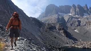
Once you're north of Minaret Lake, this is an off-trail route (class 2). There are pockets of intermittent social trails, but most of it is unmarked talus & boulder fields. There is a small amount of class 3 (scrambling with use of hands) mainly in the boulder field along Iceberg Lake, and depending on how you choose to hike it. Once you are down at Iceberg Lake, you're back on regular trail. Trekking poles are recommended.
Taking a fall anywhere along Iceberg Lake would be catastrophic; there is exposure, and the boulders you'd be landing on have sharp edges and are fairly loose. Most of the time, it is covered by a steep snowfield - in which case you want an ice-axe, crampons and the skills to use them. On this trip I knew ahead of time there was no snowpack left.
From the north side of Minaret Lake, the official trail departs a series of campsites near the shore, and becomes intermittent and very steep - around 40-50* angle. If you're hitting the talus/boulder slope on the very southern end of Cecile Lake, you've gone too far. The trail is clear enough to indicate that you go up into switchbacks between two granite mounds to the east when you are just north of and a good distance above Minaret Lake. In between the two granite mounds, the route levels out and there should be a small tarn to the north-east. Head north-west from here towards Cecile Lake. You'll be walking up a short easy, but steep boulder field before you see Cecile Lake. The views of the Minarets on top are breathtaking.
From the top of that section, you travel a mix of scree, talus & boulder fields, contouring the east bank of Cecile Lake. There is excellent camping at Cecile Lake, but the sites have a good amount of wind exposure and water is not easy to reach if the nearby tarns are dry as you're up high from the lake.
If you enjoy my content, please consider donating to my Patreon using the link below. Your support helps me to create and improve my content for years to come!
/ wildlandexplorer
From Cecile to Iceberg Lake is also very steep - especially from the Cecile outlet stream - 50* angle. If coming down from Cecile, you want to aim for its outlet stream. Many people cut away too early and end up in more technical terrain. Which is fine if that's what you're after!!
If you stay close to the outlet, there is "trail" which is again 45-50* angle. It's loose over hard dirt and easy to lose your footing and slide. Then you will be going in and out of walking through a complex boulder field that contours the east bank of Iceberg Lake; there are a few small random cairns along the route, mainly along Iceberg. They basically only serve to indicate if you've gone way too high or way too low from the "walkable" non-climber section of the route.


Thanks for sharing! 12:01 - The traverse between Cecile and Iceberg was perpetually covered in snow 20+ years ago. It was sketchy as all get to cross it in the morning. One slip, and you'd ride all the way down into a bath in Iceberg, which was then often covered in - you guessed it - icebergs. I'm not sure how much easier the boulder and scree is though.
I did a lot of research on that pass and read about the guy that died exactly that way in 2017 I think it was. A couple was doing that traverse early season and the dude slid right off the ice, over the cornice and into the rocks / lake and died instantly. Folks act like that pass is no big deal due to how popular it is but I think for that reason it's one of the more dangerous cross country passes in the Sierra. A number of folks have died crossing it. These days if you pay a yearly subscription to CalTopo or some other similar method you can look at Sentinel satellite imagery to determine if there's any ice at all - which I knew it was ice free weeks before I went.
@@WildlandExplorer Thanks for posting. I believe it was in early August, but in a year with late season snow, and enough to cover the traverse. They were indeed early in the day (which I would never do), going from Cecile to Iceberg, which I think is the harder way (both directions are hard, to be clear), both fell, and one was killed.
I've made the traverse twice. First time was with no gear, not even trekking poles, late in the day, in about 1992. I was young, and somewhat foolish, but smart enough to go late in the day, and went very slow. The snow was just soft enough to get my feet planted. The second time I talked with the rangers who recommended an ice axe. I instead took crampons, and I'm glad I did. An ice axe would not have hurt tho. This was in about July of 1998 is my guess.
I'll be there in about 3 weeks. Looks like this year's snowpack has the area looking like early July right now (8/24). I've only found one report of someone doing the traverse a few weeks ago, and he said it was as dangerous as ever, snow over layers of ice, over boulders. I will be doing the traverse late in the afternoon, when it's very likely to be fairly soft, and going from Iceberg to Cecile. I will be taking microspikes at the minimum, unless I can get absolute confirmation the traverse is snow free.
I'm not some badass, but have a lot of experience, and used to do a lot of climbing. One of my strengths was not falling, and being safe. If I have to turn back, I will.
Some people equate this traverse to the paths on the west sides 1000 Island and Garnet, and Garnet to Nydiver. Not even close. This is far more sketchy. The hardest part of those is route finding.
We did the traverse last weekend from Iceberg to Cecile. Lots of people going from Cecile to Iceberg but didn’t see many going the other way around. Good call on going later in the day. Snow is softer and easier to plant your foot in in the later afternoon. Good luck and be safe!
It's interesting to hear you mention how difficult it is, being that experienced with the area. I wasn't sure if I was imagining the difficulty. I feel better about it now, lol. Be safe out there friend!
It is fascinating, how different the same place can look. We went the loop from Agnew meadow to devils postpile via Lake Ediza- Iceberg-Cecil-Minaret Lake, started at 7am, ended at 8pm in August 2023. And we totally underestimated the trail. Iceberg lake was completely covered in ice and there was a big snowfield from the trail to the waterfall at iceberg. We hat microspikes and thought after Iceberg, there would be a trail again, but there wasn’t one until Minaretlake. It was exhausting and scetchy. There we met a man, who died 2hours later at iceberg lake. So sad and shocking. But I’ve learned a lot that day and will never again be that naive going in the mountains without knowing, what I’m doing… and still… it is absolutely amazing and beautiful out there.
You’ve been busy.
This is amazingly beautiful!
Great highlight video. I’ll be watching the full version tomorrow when I have more time to relax..✌️
Absolutely. Most of the videos have clear early summer days of the Minarets. The smoke is usually something people try to avoid, but I made it work to get a unique view no often captured. Thanks for checking it out!
Wow, I remember seeing the Minarets from a lookout point near Mammoth Lakes some 60 years ago. Thanks so much for sharing. The remaining glaciers seem awfully small. This makes the Middle Fork of the Gila River seem like a walk in the park!! I am glad you are still Out There!
Thanks! I think the Sierra had a pretty bad snow year in '20-'21. Hoping it improves. Some of the high altitude lakes are beginning to see some stringy blue-green algal blooms. A worrying sign of the changing times. I imagine the glaciers on the eastern slopes are just going to disappear completely at some point in the next decade.
will have to check out the longer version, wow this is awesome thanks for sharing.
Simply beautiful, is it ok not to camp overnight but to return in the same day?
Absolutely! I saw a number of people along that route with just day hiking packs.
Amazing place! Beautiful footage! Big like from Switzerland.
Crazy to know this footage is getting around the globe. Thanks so much for watching and for your support!
Beautiful place!
gotta say, this video is absolutely gorgeous
Thank you! I'm still surprised how good it came out, lol.
Looks like a great trail!