Why California is an Island on Old Maps

HTML-код
- Опубликовано: 8 дек 2023
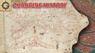
- Maps from the 16th to the 18th century are riddled with errors, myths, bad theories, & lies but one really stands out amongst the others. For hundreds of years, California was depicted as an island.
If we go to raremaps.com and type in the Island of California, we see one map after another. I’m not counting every single map but there could be hundreds listed here. This may very well be the most widely published cartographic error in history.
RareMaps.com Maps
--------
www.raremaps.com/inventory/se...
Social Media
-----------------------
Map Shop - thegeographygeek.com/
Instagram - / thegeographygeek
Patreon - / geographygeek


Since before Japan opened up to the outside world, their primary outside contact was with the Dutch it makes sense how a Japanese map would be one of the last ones to show an island of California.
Thank you RareMaps.com for supporting another video! Their maps and descriptions are a huge part of the research and visuals that go into these videos. You can purchase your own map with the Island of California on their website - RareMaps.com
California Natives were seen as black skinned with hair like Ethiopians it was said Queen Kalifa discovered California.
Is it possible that at the time these explorations were happening, the Salton Sea was in full flux and the Colorado flowed through it to the Sea of Cortez? That might explain the mistaken impression that the left coast was an island.
Not a chance. The reason they assumed it was an island was that THEY NEVER WENT FAR ENOUGH NORTH to be sure that it WAS actually an island. It's just that simple. Why didn't they go farther? They couldn't imagine that they had found the longest peninsula in the world. (Malay is close to the same length, over 700 miles.) And good luck trying to find fresh drinking water along the west coast of Baja. I can sum it up in one word: hubris.
Wasn't the Salton Sea man made? An accident if I recall.
The salton sea was accidentally created from agricultural run off
I don't know a lot of the history or even geographical names but the part I think of as being Mexican, Baja California, it would make sense to me that it was easy to misunderstand
@@ronjones-6977 Nope, in 1539 and 1540, two expeditions reached the head of the Gulf, and discovered and explored the outlet of the Colorado River. They both reported back to Cortez that California indeed was attached to the mainland.
What I found more notable than whether or not it was connected to mainland, which can be attributed to the limits of exploration, is how wrong they got the scale. Compare Baja to Florida which they pretty much nailed despite southern Florida being insanely difficult terrain.
I've had this question since I first saw one of your videos!
I had no idea the name “California” was so old!
Come from the Queen Chalifa
The Spanish knew from the 1540s that California was a peninsula and not an island, and showed this on what atlases they had. Before the Eighty Years War the Dutch, with their Spanish connections, originally showed California as a peninsula.
The problem was that the Pacific was a "Spanish lake" until the mid-18th century...if you weren't a Spanish vessel, you tended to get attacked and killed. The Spanish themselves didn't give a flying flip about anything that didn't relate to the Manila Galleon trade route, so anything north of Cape Mendocino was terra incognita and the west American coast itself was considered too rocky and dangerous to approach closely, which is why San Franciso Bay wasn't discovered until much later and by land.
Based on fantastical Spanish speculation that fell into the hands of Spain's rivals, and with no practical way to verify the truth, French cartographers began to show California as an island, and since France was top dog under the Sun King, soon every atlas in the non-Spanish world--which would be just about all of them--showed California as an island, until Spain's rivals became powerful enough at sea, and Spain itself became too weak to resist them, that these ships could actually go and see what the west coast of California looked like.
Not hundred of years, from Cortés just 50 years until Urdaneta discover the return voyage from Philippines to Palo Alto and navigate by the coast to Acapulco...
If you drive up the 395 from Palmdale to the north, the high desert, you could see that the land was a washout. Probably an old lake in Wyoming's southwest corner broke loose and washed the soil filling in the old ocean that was between California and Nevada and then creating the grand canyon. You could kinda tell on Google maps and more if you just drive around those areas and look around for yourselves that some kind of catastrophic event took place there.
The lake on the old map was 200 miles long surrounded by mountains that’s what close in the Red Sea
Are you a geologist? Just curious.
@@markflierl1624 you could see for yourself where the the sand and soil flowed with a rush of water. Right from Mojave to Tehachapi and down into Bakersfield was a wash. In those areas you can find sharks teeth. There's even a place called sharks tooth canyon.
Also, you know death valley is below sea level. Utah has a salt flat. You could tell that Wyoming, Idaho, Oregon, and Washington is where a catastrophe originated. They used to have inhabitants and cities in and around the areas where the inland sea was. When the disaster happened everything was buried. That's why Those higher desert communities in California has a lot of gold mines. Mainstream channels like this one is probably a mislead. They scoff at the idea that there was an inland sea and California was once an island, but in my opinion, they are just regurgitating a Mainstream idea. I encourage you to look with your own eyes and possibly travel to these areas and look at Google maps to find your own beliefs.
Thanks for the insight. @@vademecum8173
@@vademecum8173 - There was a giant flood at the end of the younger dryas.
There is one map which depicts California as an island and also includes the Mexican peninsula always used as an explanation for this mistake. Which would take into question whether that is a legitimate explanation.
This I think is what I assume the answer is, I think I'm on the third ad now, waiting to watch this lol
Yep, blame the Dutch again for their lack in fact checking! ;)
But that is the way science works, take the knowledge of others, complete it with your own knowledge, and until others prove you are wrong, it's the new 'truth'. Step by step, mostly small ones, we discover the natural world and the universe we live in. There is so much more to discover!
Heh, 3:10 not only shows California as an island, but has the Rio Grande (labeled as "R. del Norte" flowing out of Nuevo Mexico past Santa Fe) flowing into the Pacific as well!
The areas are coral where it shows the water between Cali and the east
Thank you very much Spain for discovering Alta California.
Why would you think it’s an error. To say those explorers were that stupid to make that mistake is crazy. If you do your research California was an island until the mountains collapse and that 200 mile lake came running and push all the segment and rocks and filling the Red Sea. That’s why they have so many earthquakes because the ground is just sent from that flood. Look at google maps and look how the land flow
No.
well said!!!
Our current maps are inaccurate as well. Who's to say who is right and who is wrong??? 🤷🤷🤷
The world’s climate was very different in the 1500s, 1600s, and 1700s. It was the middle of the Little Ice Age (1350-1850). That would mean a lot more snow and ice draining from the mountains into the lowlands. The Salton Sea last flooded to merge with the mouth of the Colorado River and the head of the Gulf of California as recently as 1907, making the peninsula of the Californias to extend up as far as Palm Springs! Then the Salton Sea has been slowly shrinking ever since. Also the phantom Tule Lake flooded in the record rains of 1862 (at the lowlying San Joaquin Valley) putting all the land from Bakersfield to Sancramento and the San Francisco Bay underwater for a number of years until it started drying out again. Tule Lake reappeared in minature form as recently as January 2023. This made the peninsula of the Californias in 1862 to extend from the San Francisco Bay for hundreds of miles east and south until approximately present day Bakersfield. The Californias really have been almost an island even in the last 250 years of European settlement, except at a very narrow neck at the San Gabriel Mountains and the Grapevine (Palm Springs to Bakersfield). Before the 1500s & 1600s there were even greater possibilities for climate changes (and even earthquakes) changing the topography. We do know now (through the study of tree rings) that the 1700s brought a disastrous 40 year drought (1720-1760) which made a wasteland of Alta California. That could explain why the Spanish did not bother much with Alta California until the drought broke in the 1760s, concentrating on Baja California ( ironically to us). Could the drought have dried out the Salton Sea and the massive but shallow Tule Lake, giving the Californias their present configuration? That is about the same time mapmakers starting depicting Alta California as mainland and Baja California as peninsula. This opens up the possibility that the old mapmakers may not have been as ignorant as we depict them in showing the Californias as near shore island (only missing the narrow bottleneck of the time). Maybe it is us who are ignorant of all the changes over the last 1000 years+ (?).
It's us!!
0:30 so they thought the Mexican California was an island cause they didn’t just keep going north? Lmao
Seems pretty obvious to me that the maps showing california as an island were either made when the ocean levels were higher or were inspired by maps from a time when the ocean was higher.
No.
@@michaelinnes2754 Yes.
Or they were mistaking Vancouver Island and the Gold Coast for the same area, that land bridge from Alaska looks too far South.
@@JS-jl9gb If Florida was completely under the water, so would the coast of california right? But we see california on the map so the water wasnt so high as to completely cover california in water, at least not at the time the source map was made. My best guess would be this map was made far enough after the flood that land was becoming visible again but was still high enough to where california couldve been an island. Also keep in mind that isostacy and eustacy can come into play here too. As the waters recede, the land theoretically could rise rise from less weight. Its possible this map was made where the land just handnt bounced back yet. Either way, it was still related to water levels rising and falling.
@@JS-jl9gb Its impossible to know exactly how much of florida was underwater at the same time california was an island. The size things appear on maps rarely reflect the actual size in real life. For all we know, the channel was a river and florida couldve been much smaller. Either way we know a couple things for sure. We know there was a worldwide flood and we know as these waters receeded california would've been an island for some time. How and when that relates to Florida's appearance on this map I cannot say.
Then explain ship's found buried in the Arizona Desert???
Links?
9:25 California - New Mexico - Florida
Nothing else in between
New Mexico was much bigger back then including most of Texas, part of Oklahoma, Nevada, Colorado, and Arizona, however part that was owned by French is missing, part of Texas to Louisiana and part Mississippi to Alabama coastline a part of Florida at the time owned by the Spanish.
If there is the "big one" as in a giant earthquake that will split California into two, the western side of the California would become an island, funny how old maps can possibly foreshadow the future hahaha
I hear they’re filming Escape From California starring Kurt Russel.
The Secret of proving California was an island " The Northern Border .
China Mountain , Port of Idaho , & Fusang .
It’s “Baja-California”… they hadn’t yet mapped Northern California like Southern California.
The North was called Alta California. Explorers new it was not an island for many years before but a few people kept the myth going.
Ironic that it predicted that California was full of gold.
I wish it was an island now....
There were no states yet. California was just drawn onto the west coast maps as we know it. The island is sunken off the coast
the island indeed sunken off the coast.. only remains of the Queens Castle exists and in the form of a prison, like all of our Queens Castles on Tameri.
Álvar Núñez Cabeza de Vaca has to be one of the best Spanish names ever. A.N. Cow Head
De Vaca did not go through the Southwest US. He went through the South Eastern US. The Gulf coast. From Florida to Texas
They got California and Vitoria Island mixed up.
Vancouver Island?
Your comment makes sense to me, when I think about that
They sent the wrong people to do the cartography.
South America wasn't accurately surveyed until Percy Harrison Fawcett went down there in the early 1900's.
They probably were better at fighting the locals than doing the skilled mapmaking end of things.
I came here looking to see if there were any flat Earth types claiming that California is secretly an island and we are just being lied to.
Great video! The conspiracy community needed this one lol
Can we have the option to turn it into an island? Before mother nature does? If we do will it float away?
We can dream...
There are always the rumors of California falling into the Pacific in the next big earthquake. Consider the possibility that the rest of the US slides into the Atlantic. As a resident of California, I am comforted by the fact that we would then be an island. ; P
Nice hearing people bash California and the residents. We all aren't rich, Hollywood types and leftists (out there) idea ologies. In fact most Californians are conservative or Constitutional libertarians. You'll find out that in November 2020 California voted RED. The only semi blue areas are San Francisco, LA and parts of Sacramento. Maybe u should appreciate what agriculture in California brings to the U.S not to mention the huge ports. California is in the middle of a huge change in the next few yrs. The newly formed New California has already been established Constitutionally. Keep an eye out for the big changes in State government that will surprise many. Back to a Real Constitutional Republic we have formed. Bye bye corrupt politicians 😎🇺🇸💃
Your'e just jealous and ignorant.
7:05
Haha very fun, I have never heard of it
Oh boy
Thanks for your work Geog. Geek,
A woman in the modern era actually found a Viking-like ship
north of the gulf of California. As always, a flood destroyed
it very shortly thereafter. Funny how that always happens.
And there was gold in California. Anza discovered natives
mining and working it when he arrived. The modern propaganda
says the Americans discovered it, but that is not true.
The Big Bend of the Rio Grande River of Texas was known
by the Spanish, but took years for the Americans to realize.
Too bad its not an island in real life they can stay down there
Naval blockade.
Another banger 🔥
Love it ✌️😎🇺🇲
Thanks man!
They didn't go far enough up Baja Cali .. haha
Actually they did but some other guy decided to lie about it
Salton Sea was an engineering disaster caused by the army Corp of engineers
Is it possible the 10 route and the Mexicali region were under water at some point? Idk, just wondering.
When the maps were made they were not. Maps should be accurate when made. Maps should not be fiction.
No
Seems like intentional misinformation. A northern trip would rather take the strait then endure pacific coast. The dead end would be a costly waste of resources for one's competition.
If only California was an Island for real.
Yeah like Hawaii. That would be awesome
Surely they just mistook Calofornia for the Gulf of California?
California being an island would be the good timeline.
Alvar Nunez Cow Head?
Weird.
Wish it werent an error
is it possible the valley was lower but has risen because of tectonic activity
How fast do you think tectonic plates move?
@@gordon1545 And I thought the map makers 200 years ago were dumb. lol
@gordon1545 considering there's a massive fault line that happens to run through California you don't think there could have been a massive earthquake or event that might have created a significant shift at some stage or over several stages?
during the Sumatra the sea floor moved west up to 20 feet and upward by 2 feet and that happened in a matter of seconds yes geologic changes normally happen slowly but events like that have probably happened more often than we know @@gordon1545
@@ajfracinglol no.
How they saw Baja from Mexico
They sailed there dummy
Sounds to me like they might be mixing up California with the legend of Lumeria
Lemuria.
Nope, not even close
@shrimpflea okay, so what is your theory?
North America was in an Ice Age . I ndia has it in their history . Fusang.
I would like to know of so call black women that were on this island who were they? Where they came from? Their history etc. please any information Thank you
Queen Kalifa that's why there is a woman in the California seal.
American Indian that the USA governement relabeled as Black Americans. We have many many Indian tribes and NONE of us are Africans and share zero blood with Africans. WE are the American Indian!
Baja California is the original and only California, the American California is just an extension of the desert.
I love to luagh everytime someone says they know this or that as if you were there and got it all figured out thank god for your wealth of knolage
That's knowledge.
Prophesy? lol
You have bad info on this channel ....after the phoenix event of 1488 the topography of north america changed drastically. Thats why there was gold exposed for the gold rush
Nonsense
It was premonitionary wishful thinking.
Very Good!... #144 ✝ {12-28-2024}
These maps will probably be accurate after California finally has "the big one".
While the west coast may break off, the east coast is currently sinking as much as .08 inches a year.
Too bad it wasn’t an island in shark infested waters.
If only one of these people had opened google earth this could have been resolved pretty quickly.
Exactly
Hi. I opened it years ago. What my eyes see is beyond damning.
Yes, we be Indigenous American Indian NOT African NOR black blank bland bleak bleach blond Blanco blanc blackout bla bla bla Websters Dic!!!!!! And Ruler Kalipha be ruler of Kaliphornyh
bs
this guy is a lie making it all up
the reason they thought california was an island was because they went up the gulf ,,not that difficult to figure out
there have been erased Natural Disasters and Resets
How if true does that apply to this?
Ok.
@@gordybishop2375 The great Oldogaheaden upheaval caused the sea between California and the continent, AKA the an Andreas fault, to rise up and drain. This is why seashells can be found in the surrounding topography.
@@bluestormcloud791 but that was way before the maps were made, not afterwards
if the mud flood happened as explained (around the 1700s), then that would explain it, possibly, the mud once the flood subsided filled in the gap which would explain the landscape in that area as well. who knows . . . the people who survived the flood may have used that opportunity to bury their crimes and create new land and steal the rest (edited to add just as i finished typing this the narrator mentions jesuits lol). . . the mud had to go somewhere . . . no idea but makes just as much sense as this explanation @@gordybishop2375
Because they thought it was Vancouver island.
bc Fake History
I love the tartaria theory but sometimes there is legitimate reasons behind things like this
WTF 😂
Bla bla bla……fake news
poop
That does make sense
I think they are disappointed it’s not an island.
No.
You are American, have you never read steinbecks books on baja califorinia
Not saying you do not read books, as an English person influenced as a teenager by Steinback and Orwell. Steinbeck just told your lots version of reality😀
Salton Sea?
That was created just 100 years ago