WORKSHOP: El Reno - May 31, 2013 mega-tornado analysis - with Glenn

HTML-код
- Опубликовано: 21 окт 2024
- Tim Vasquez (former Air Force meteorologist) breaks down weather patterns and events piece by piece. I'll give this a shot as a series and see where it goes... if you like it please like, share, and subscribe and I'll keep cranking them out.


I found your channel by accident, and I'm so thankful. I spend a lot of time trying to learn and understand about severe storms and tornadoes. I've been fascinated since I was six years old. My poor math skills kept me from majoring in meteorology. I'm particularly interested in the 2013 El Reno, 2013 Moore, and 1999 Moore tornadoes. I watch every vid I come across. I appreciate very much your analysis of this tornado. I look forward to more workshops in the future. Thank you!!!!
It is a VERY good idea to bring along someone of lesser knowledge, asking the "stupid" questions. Far too many storm chasers have a hard time understanding what amateurs don't get and just assume things that are very difficult to understand. So, nice move!
This is a fascinating look at the El Reno event. Thank you for posting this.
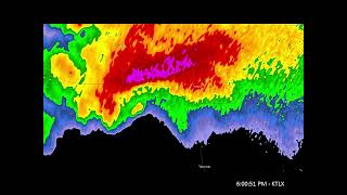
What I'm struggling to understand is your interpretation of the storm relative velocity displays at 6:00 PM and onward as if there was a single point-source tornado circulation.
Instead (and correct me if this is incorrect), my impression is that there was a large, and expanding meso-circulation/cyclone like a two-mile wide inverted bowl (or chimney?) over the ground rotating counter-clockwise. Along the rim of the bowl is where large vortices developed that many chasers apparently mistook for the main tornado.
IMO, the error of mistaking the vortices for the main event appears to be what cost some chasers their lives, because the vortices had behaviors and motions that didn't make sense from the perspective of a typical tornado, and only made sense when the enormity of the El Reno meso event was understood in it's full context.
So, back to your analysis. Assuming that my "visual model" (inverted bowl, etc) of the storm is correct, can you look at the 6:15-6:25 storm relative velocities and identify the individual vortices spinning up along the edges of the meso? If so, is it correct to presume that the vortices would be most-well defined close to ground level on the storm relative velocity radar at 0.5 degree tilt, and the vortice signature would become diffuse or lost at higher altitudes?
Thanks again for a fascinating presentation!
Your insights are always a treat Tim, thanks for putting this together.
Came across this video by accident and kept listening. Interesting. Thanks for sharing.
This is why I should have stayed in the GIS field. The breakdown analysis of the tornado development, the radar and base relativity AND then the shapefile overlays?! It's been 4 yrs since this video posted, but I'm so happy right now.
Wait...you have Tim Samaras at the intersection of Reuter/Radio before the tornado has even reached 81. The tornado was mostly across 81 by the time Tim got there which is why they didn’t go south, which had been their plan. They kept going forward, thinking they could still get out ahead of but didn’t know as it crossed 81 it turn left, got larger and faster. The tornado picked up the Cobalt around the intersection of Reuter/Radio.
Appreciate the clarification.
This was interesting. I don't always have access to as much data as I'd like, so it's fascinating to see the thoughts and data of others for these historic tornadoes. Thanks for putting this out there.
This was great info... I've never had a lesson or the opportunity to use data like this so I really liked this video. I appreciate it an wish I had this computer program to use. Please let me know how to get this type of data. I'm from Tuscaloosa Alabama an love studying weather I just wish I could go back to school to study meteorology.
I really enjoyed the calm analysis about the el reno tornado!
Wait so according to this at 32:00 the main circulation hit Tim Samaras and his crew. In other videos the narrative is that a sub-vortex came out of the parent tornado and hit his position and loped around and the main part of the tornado was south of him. Skip Talbot does a video where it shows the center of the tornado going south under Tim?
very informative and eye opening video. good to remind people that radar and models aren't perfect and how quickly and unknowingly such a powerful tornado can form. many chasers were very lucky this day to have not lost their lives.
Agreed!
this is incredible! Thank you fo sharing. I'm a pre-med student but my hobby is storm watching!
I was just going to put this on & let it run sorta in the background while I did stuff on the 2nd computer...but ended up giving it my full attention.
Interesting stuff / good presentation!
Great work, Tim...very interesting to see it broken down like this.
Tim,
My 4 th time watching this video from the analysis you did in July of 2015
Very important data / information here...
Very interesting reading all the ingredients before everything POPS East of the dry line...
I'm intrigued how all three Super cells merged together along the I ~ 40 corridor west of El Reno like they did... Much more research is required to fully understand this day...
It will happen again it's just a matter of time...
F5 / EF5 ⛈💨🌪
That may have been why the tornado was so freaking powerful
Great job - careful, painstaking analysis that makes sense out of the chaos when you watch an average chaser's video
Thank you!
Thanks for the great video! Very informative.
Great look at the El Reno workshop! I have subscribed, and hope to see more future workshops.
I was 7 blocks to the south of the Moore may 3 1999 tornado,would love to see you do a workshop on that storm....The RFD on it was so intense i was getting gust up to 75 knots going into the storm.Remeber being on I-240 near sunnylane road.....that was crazy.
That would be great to see also!
Great commentary on the progress of an epic storm with key elements to watch if you have an interest...plus, you can increase the bark count to 5, as my 2 went into orbit.
Stuff like this is being lost in the day and age of computation and computer modeling. Too many amateur chasers and weather enthusiasts focus on models, even in the short range. Being able to pick out these details is hard, but as you show can be done and is very valuable in predicting these situations. Models are awesome and help forecasters a lot but I think the pendulum has swung a little far towards that side of forecasting and will right itself eventually.
Yep, the real trick is finding a balance. Also models are very good at some things, and not at others.
Is it me, or is there a near-standing gravity wave in the cap prior to convective initiation?
at 29:30 did he get hit by the tornado? just curious cuz the camera went like spinning
"Excellent!" As always. Thanks! :)
geonerd Many thanks!
Awesome presentation! Kudos.
Wasnt this tornado basically a 2.5 mile wide bear cage with a main tornado and some sub vortices?
Essentially
I remember watching this on TV. It was insane. I have a random question. Trying to find a good atlas for future storm chasing but I have to order one online. Which atlas do you think is the best for storm chasing?
john dopieralla For a larger scale picture I've always preferred the Michelin road atlas, which does a good job putting the road network on plates rather than pigeonholing the roads into state-by-state pages. For tighter detail I prefer the "Roads Of ..." series, but the DeLorme books are pretty good also.
Wow awesome amazing sceary and what a cool presentation
At the beginning going over the bridge, a year and a half half later there would be an ef-4 tornado Crossing that same Bridge.
Dang I see 2 couplets at 21:50.. crazy storm, thanks for sharing.
What is the radar data viewing software that y'all use? Is the software able to pull real-time radar data as well?
I use a mix of GRLevel2, AWIPS, and Internet sources. All of them do bring in current data.
GRLevel2 and GRLevel3 tend to be the best software for Windows-based platforms.
this is amazing
What software was that you where using? I was on the weather graphics website looking at some, or does anyone have any recommendations for just a hobbiest, somthing not crazy expensive
This is GRLevel2 with some saved binary radar data files.
May,3rd 1999 a mile wide tornado ripped a path through OKC and Moore causing the first issuance of the Tornado Emergency.
It's too bad the TWISTEX team didn't have access to this level of technology on that day. If they did. I have my doubts they would driven through the debris cloud even if they couldn't physically see it due to it being rain wrapped.
AWESOME STUFF!!!!!
Can you send me a link to the color tables you use? Thanks!
Hello friend, I am a fan of tornados, I want to be a hunter, I live in Brazil, how do I contact you?
Great job.
On the first radar image, are the streaks on the radar indicative of the moisture surging north?
john dopieralla I suppose I should have mentioned that. It is showing the cloud streets and/or transverse bands that have developed in the moist sector. Sometimes I'll look closely at the pattern for breaks suggesting the presence of a boundary, but I don't recall there being such an example on this day.
Great analysis
Caught a second of Leonard Cohen in the beginng....great album
This is good stuff
Appreciate it!
That outro though hahahahhaha
hello tim hows it going I have a question what are those flag things called with notches on it
david marshall are you talking about the map showing the temps and dew points? If so, the flags are the wind barbs, showing direction and speed.
Fascinating!
I heard that cat and I was partially distracted so I didn’t realize where it was coming from and I immediately paused the video frantically searching for my cat who I thought was in trouble 😐
I would like to know, where I can get access to these data files?
Ik I’m late but the app is called gr2 it’s 200 dollars but it’s one of the best purchases I’ve ever made
And search up radar archives to get access to the radar files it’s on noaas website
Keep cranking them out
I have a cat on me as I watch this.
Perhaps he enjoys the detailed discussions as well.
Imagine that nothing developed that day .. Time would be still here ...
I think this ef5 megawedge was a sign of things to come if climate change isn't slowed down
OKC will be hit someday. It's just a matter of time.
I personally think we could see a tornado even larger than this giant someday
0:53 mmmm I love Yiros (Gyro)
Opa! in Rowlett has pretty decent gyro.
Interesting but you are talking way over my non-scientific head. Good luck.
Danger
Is the one guy on drugs? He doesn't even remember this storm?!
niagra898 he doesn't seem to be a meteorologists or even a "weather nut", at least, not at the time of the videos filming. with no indications of why he is there i can only assume that he and Tim are friends and that Tim is teaching him radar and satellite signatures and how to spot them with this historic storm as the sample.
you do realize some people don't have good memory? this did happen like 5yrs ago or so. that's plenty of time to forget if you don't have a good memory ESP if you wasn't effected
Seems to me that he's more likely a former Air Force meteorologist (as it claims) but does something entirely different nowadays. As friends, Tim just decided to whip up the data on this historical storm and they went over it together as a little refresher. It sounded like he had some basic knowledge in weather systems but was quite rusty as if he hadn't touched up on any of these things in a while.
I assumed he was asking for the audience.
is this a nerd thing? i dont do nerd things
I think it is.
Any way we can just pick your brain for all the information? haha sorry