Model Builder Map Tutorial - Arc GIS Pro

Поделиться
HTML-код
  • Опубликовано: 28 авг 2024
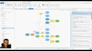
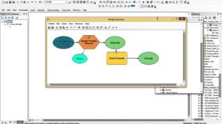
  • In this demonstration tutorial, we use Model Builder in ArcGIS Pro to perform a series of selections, intersections, and clips to find the most desirable place to live in the US. To do this, we must experiment with different attribute values from various layers, like populations density, average income, percent educated, etc. Since the workflow has to be iterated many times to find the best location, it is perfectly suited to a model which can be easily modified and re-run. The instructions, data, and a model toolbox are posted below. If you find this video helpful, please like it and subscribe to the channel. Thanks!
    Instructions: drive.google.c...
    Data GDB: drive.google.c...
    Model Toolbox: drive.google.c...

Комментарии • 18

  • @tonytellum7636
    @tonytellum7636 3 года назад +3

    Loved it. I am new to ArcGIS Pro and you taught me more in one video than I received from reading numerous chapters. Your pace was great and your instructions were easy to follow. Thanks for helping the neophytes.

  • @bobyorr55
    @bobyorr55 3 года назад +1

    I don't need this class after this semester but this really helped and I felt the need to let you know how much I appreciate this tutorial! I subscribed to help out a little because you helped tons!

  • @diogenes2454
    @diogenes2454 2 года назад +1

    Great video,
    Thank you.

  • @shadikalash3886
    @shadikalash3886 2 года назад +1

    Great. thank you so much.

  • @nataliabermudez7476
    @nataliabermudez7476 2 года назад +2

    I am seeing that you are using same tool more than twice (select), is it possible if you can connet different inputs over only one same tool, giving different outputs ? Great Tutorial, thanks!

  • @maodokan
    @maodokan 4 года назад +3

    thanks for the tutorial. Could I have a tutorial on Model in Arcmap and also the use of python to automate the model?

    • @donaswa
      @donaswa 4 года назад

      Here's a good tutorial on using Model Builder in Arcmap. learn.arcgis.com/en/projects/find-areas-at-risk-of-flooding-in-a-cloudburst/
      And here's one for using the Python API. www.esri.com/arcgis-blog/products/api-python/analytics/visualize-regional-growth-with-building-permits/

  • @mohamedasma8949
    @mohamedasma8949 3 года назад +1

    i have some question . a have a feature . the her attribute table i have comumn fclass . i wonna create a new column hierarchy with model builder i just need some help someone who verify with me my model please
    i need have values based on the fclass classification

  • @heathershearer3420
    @heathershearer3420 3 года назад +1

    So awesome and useful thank you. Do you know if there is any way I can do similar, but instead of setting my selection expression in the model (i.e. income => 20K), to have a form where a user can input from a drop down list (like in a survey) and that creates the selection layer? If I bin the variables, say into quintiles, and a user can select one of 5 in a drop down list?

    • @conorchurch7616
      @conorchurch7616 3 года назад

      Heather, I had the same question. Did you ever find an answer?

    • @heathershearer3420
      @heathershearer3420 3 года назад

      @@conorchurch7616 No, sorry...

  • @bilvotel3119
    @bilvotel3119 3 года назад +1

    Hey, thanks for the tutorial. Could you explain to me what that little bit of code which you used for not saving your data in the gdb does? 5:36

    • @MapPractical
      @MapPractical  3 года назад +2

      That code creates a new GDB in the project folder called scratch.gdb. I use it so all the intermediate data is easy to delete and doesn't clutter my main GDB. Cheers

  • @tonytellum7636
    @tonytellum7636 3 года назад

    I tried the Auto Layout but it rearranged all of my processes in random order. I originally designed them in a top-down structure. Why did Auto Layout rearrange the processes? It still looks like my processes are running in the same order I designed them. It’s just disconcerting to see them randomized. Its easier for me to follow the order I wrote them. Especially if I have to diagnose errors.

  • @aarizahmed4514
    @aarizahmed4514 3 года назад

    Can we also build model for optimal routing of canal construction?

  • @inkarsaduakassova692
    @inkarsaduakassova692 2 года назад

    Hello. Where can we download the map you used?

    • @MapPractical
      @MapPractical  2 года назад +1

      It's in the video description. Cheers

    • @CalvertHewlett
      @CalvertHewlett 21 день назад

      @@MapPractical Please I can't download the dataset you used. It says "404. That’s an error.
      The requested URL was not found on this server. That’s all we know." Can you please help me, I want to try and replicate what you did.