Landscape Axon Tutorial using Google Earth рЯМО & Photoshop [Without plug-ins]

HTML-–Ї–Њ–і
- –Ю–њ—Г–±–ї–Є–Ї–Њ–≤–∞–љ–Њ: 2 –Њ–Ї—В 2024
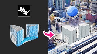
- This particular axon is another great way of illustrating the relationship between the landscape, terrain, and your project, and the context in a semi-isolated view compared to a full aerial render.
рЯУ§ Download Google Earth Pro: www.google.com...
рЯУ§ Download Google Earth Focal Lengths: gumroad.com/l/...
Thanks again for watching! Subscribe for free tools, tips, and tricks to accelerate your design process! Work less design more with Archi Hacks.
рЯЪА Follow us on social media for the latest updates!
рЯУ± Instagram: / archi.hacks
рЯЩМ Facebook: architec...
рЯФЧ Website: archihacks.com
рЯФЦ Use coupon code ARCHIHACKS10 to get 10% off on your first order on Fiverr: fvrr.co/3Hw6f8d
рЯУҐ Get a free month's trial with Audible when you use the link: www.audibletri...

![Google Earth 3D Architecture diagram [Quickest Method] Step-by-Step](http://i.ytimg.com/vi/zXySMOnVYbo/mqdefault.jpg)


![BabyChiefDoit - Too Slow (feat. STAR BANDZ) [Official Music Video]](http://i.ytimg.com/vi/zayaxws7RPg/mqdefault.jpg)


Thanks! :) Great tutorial this helps a lot
I canвАЩt wait to use this technique
eso funciona en lugares que el 3d de google es bueno, pero coloca Per√Ї, comas, que es donde yo vivo, ver√°s que el levantamiento 3d que tiene, no sirve.
jajajaja x2, estoy trabajando en lurin y mejor hago el levantamiento a mano...
Thanks for the tutorial! Can you slow down or be more specific when you use tools in pts because IвАЩm pretty new to pts? рЯЩПрЯЩПрЯЩП
More tutorials pls.вЭ§пЄО
Man I was waiting for this so bad. Thx for the great video everytime
Really cool tutorial man! Miss the Vancouver waterfront...
It really is a great place :') make sure to appreciate it next time you're around!
Killed last semesterвАЩs studio with this FOV hack.
Amazing tutorial, thanks!
Thanks for sharing good content. Do you use mouse or graphic table for Photoshop?
hii! Once i enter the FOV the save image option disapears, do you have any ideia why?
I have no idea! But for now, you can capture the screen using your operating system
Dyummmmm this is hella nice
Woooow!!!! Love this tutorial!!! Thanks a lot
Thanks for the FOVs and the video. рЯ•≤