3D Modeling with Drones using PIX4Dmatic

HTML-код
- Опубликовано: 24 апр 2022
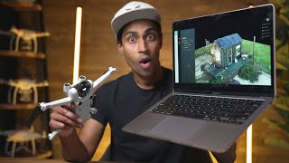
- This is how you can utilize a drone like the DJI Phantom 4 to produce 3D models of buildings. I also will show you the process of creating a point cloud and mesh using PIX4Dmatic.
Join The Survey School - thesurveyschool.com/
Join me on Social Media:
🖥️ Website: www.tamimi.biz
👤 Facebook: / tamimibiz
👕 Survey Shirts - www.SurveyShirts.com
👥 Private Facebook Group: / iamasurveyor
📸 Instagram: / ramitamimi
👔 LinkedIn: / ramitamimi
✉️ Email: rami@tamimi.biz
About Professor Rami Tamimi:
Rami Tamimi is an American doctorate student at The Ohio State University working towards his Doctor of Philosophy in Geodetic Engineering. With over 8 years of experience in the Land Development Industry, his experience revolves around traditional field surveying, civil design work using AutoCAD Civil 3D, and geospatial technology including LiDAR, SONOR, and Photogrammetric data acquisition and processing with the use of Unmanned Aircraft Systems or Drones. He is also a University Professor and creates instructional video content on RUclips.
#3DModeling #DroneModeling #pix4d  Наука
Наука


Wow. Great job. Your video helped me so much. I really appreciate you making it.
Thanks this info was gold. 🇨🇦
Very nice video! Covered topic well. I like to use a cross hatch pattern and a 10 degree tilt on the camera when flying the mapping portion, I find it helps the processing algorithm.
amazing video. thanks!
Thanks for sharing your results.
You inspired me a lot brother.
Great video Rami. Simple and informative. I use a Mavic air 2s and Litchi for gathering my photogrammetry information. Thanks for sharing
Thanks for watching!
بارك الله فيك 🇪🇬 🇵🇸
Cool Tshirt!!
Thanks!
Great video, would love to see a video on state plane vs. WGS 84
Hi Rami. Thanks always for your time do this videos. can you let me know if there is an option to trim the out border of the 3d image?
Hi man can you make a series explaining different steps involved in construction like from start to finish . would be cool to look what professionals do as im a undergraduate student so i ve no idea what actually happens. thank you
Hi Rami. Very good presentation. Using a Lidar sensor would the result have been better? Thank yoy.
Excelente Rami, buenos video , i am looking for a PPP with Emlid Studio process video i al ready watch the ppk emlid studio but maybe youo have a ppp one. thanks for yout videos
Good
In Pix4Dmapper, we can specify if image geotagged are PPK/RTK by defining accuracy columns = 0.01 or 0.02. Can we do this in Pix4Dmatic?
Great video. At the beginning you said 85 degrees, but I think you meant 85 percent overlap. To capture the facade on all sides of the house, I have seen a demo where the pilot walks the drone in hand and takes a pic every 5 to 10 feet. Can you upload to WebODM and compare to Pix4D?
can we use an iphone capture to fill in gaps not captured by the drone, and is there a workflow where both can be accurately stitched together
Hey Rami, I’m a site engineer working in the UK, I love the videos and am currently looking at adding a drone to my current inventory to possibly phase out my current GPS Rover, plus replace my total station for certain tasks, however The only thing I am sceptical about is the software aspect of things. Can you possibly make a video comparing the different processing softwares, DJI terra, Pix4D etc… or if anyone has an advice/ preferences I would love to hear it.
Oh and do you have a video where you perform a survey like this and take linear measurements? then if possible compare to another form of survey? E.g: total station or even just tape? (For example just the dimensions of your house? Or fence line?) Just thinking in terms of performing a survey and then using it to build a CAD 2D drawing to present in design meetings etc… as this could be immensely beneficial…
How much does your local FAA restrictions affect your work. Keeping in mind 400’ AGL, and 3 mile operation area from airports ?
hi, do we need to do any thing different while processing rtk/ppk data in pix4d matic?
Where good😎😎👍👍👍
Glad to hear that!
Can you publish the full specs of the laptop? Processor, amount of ram, hd and video, please.
السلام عليكم مهندس رامي...هل ممكن تدلني على درون رخيص ومتوفر ينفع لاعمال الرفع المساحي دقه +&- 10cm غير الDJI ... واكون شاكرلك
HI, cant you help me how to do oblique plan, i cant find in plan fly
COMO DESCARGO GEOIDE SOUTH TEXAS A COLECTOR DATA
What do you do with this model?
tutorial on verticality survey using total station...pls?🙏
Here you go - ruclips.net/video/PiYbU28Qrlw/видео.html
@@RamiTamimi great! Thank you
can you send the dataset
Hi, how to set the circle fly route? thanks
it's the "Waypoint" - Function
why didn't you use pix4dcatch for your high oblique pictures?
hahah you answered my question at the end. lol
Stay tuned!
Why
didn't you just plan a 3d mission? I think you can get better results...
I usually do, this is a basic workflow. I'll get into more advance methods in the future.
Great video, anyway you can check instagram messages. Thanks!