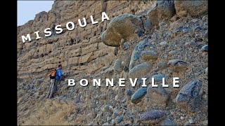
Part I - The Bonneville Flood and the Wasatch Fault

HTML-код
- Опубликовано: 7 авг 2024
- Paper presented at the Geological Society of America's Annual Meeting (10/31/2020) describing evidence of massive earthquake-induced surging in Pleistocene Lake Bonneville immediately prior to the Bonneville Flood. For more information: www.bonneville-flood.com
This paper provides new information on landforms in the areas of Sandy and Cottonwood Heights, Utah.
This is now Part I of a three part series leading to a conclusion which challenges long-standing assumptions related to Lake Bonneville.


I have been fascinated by the lake Bonneville story for decades. Appreciate your analysis. Thanks for sharing!
i live right between big and little cottonwood canyons... i really enjoyed learning the local geology and bonneville history! please keep it up and give us more
Class A detective work and analysis. An earthquake of this magnitude would have created, (as you stated) a massive tsunami heightened and compounded by the scarp features in the basin. Certainly makes sense this could have been the 'trigger' event for the Bonneville floods. Observing the geologic formations in the Portland Oregon area caused by the Missoula floods, can give a sense of the tremendous power water in this amplitude can alter geologic features.
Excellent use of old aerial photos and other graphics. Can easily 'see' what you are describing. I am most familiar with Missoula Floods. I live in Yakima, Central Washington. We have Columbia Flood Basalt, Yakima Folds uplift, Missoula Glacial Flooding, Lake Lewis backwater flooding, Volcanoes, and lava flows. I am educating myself on Bonneville Glacial Flooding. Thank you for great presentation.
What a great video!!! I grew up in Draper and hiked in the area you described a lot - always wondering about the landmarks from Lake Bonneville and the glaciers of Little Cottonwood Canyon and Bells Canyon…I moved to the northwest and really got into the Missoula Floods and how they tell a big part of the story of where I live now. Then I heard about the “Bonneville Flood” yesterday, found your video, and now my mind is blown! Thank you for telling this story of the landscape - you’ve convinced me!!!
Neat! So instead of one cataclysmic event (the sudden dam failure and subsequent flood), it could have been an earthquake, then tsunami, THEN dam failure and massive flood? Pretty compelling evidence. Interesting day in the Wasatch for sure! Thanks for this; can't wait to see more research. :)
Excellent presentation - Thank you for your work on this!!
It's an absolute tragedy that channels like this get such few views... f***** youtube and its unfair algorithms. Phenomenal work sir,👍to you, Gilbert, and the entire human effort to map these late Pleistocene events. Bravo, sub and thumbs up well earned and duly given.
Don’t know how I got here but this is a fascinating look at my neighborhood. Thank you!
I am actually using this for my report on bells canyon will make sure to reference this amazing video. thank you for the helpful information.
WOW! I knew that there have been a lake Bonneville, but I knew nothing about all of this. I had no idea the the geology of this area was, so complex--at least to me it is. Thank you for posting this, I learned a lot today! I'm subscribing as I will not want to miss other videos.
WOW!!! I grew up about 5 min from the "Authors Home", on Sego Lily Dr with the gully (Dimple Dell Equestrian park) behind my house.
After watching this I'm wondering how much of the gully was formed by the reflective waves bouncing off the area described currently as Dry Creek island, and heading west to dig out the gully.
Crazy to think how the area I grew up in so peacefully was at one point extremely violent.
Really cool work, thank you for this research and video!
Holy Cow!!!
Lake Bonneville mysteries are so present in my mind. I know these geographies well. Though your data is erudite I am glad to say I grasp it. A whole world of wonder is made clear and more ponderable
Thank you
Thanks for all your hard work!
Thanks for the wonderful video.
I very much enjoyed your video and information and thank you for putting it together. I do have a geology background and noticed that I needed to replay parts of the video numerous times to take in all the information. I suggest a slower and simpler version is needed for the layperson.
Thanks Robert. I was just trying to get a lot of information out there under the presentation time constraints of the Geological Society of America Annual Meeting guidelines. There are two follow-on videos and I am afraid they are worse as far as a lot of information conveyed with anything but polished presentation skills. If you can wade through them, they support the earlier conclusions and then go on to disrupt some other universally held theories regarding Lake Bonneville. If I get inspired, I should take your suggestion, but those who developed the previous theories haven't been too receptive and for the most part the rest of the world is indifferent, so I have switched focus to other endeavors.
It is a shame though, because in the follow-on videos I indicate that we can learn things about the Wasatch Fault and about the response of bodies of water to faults beyond current modeling which could be important in present day hazard analysis.
I've been puttering around the American Southwest for 70 years (admittedly not astutely in the early years), since about four months before my fourth birthday, in ways up close and personal. Long before fences and interstates, I got to know the landscapes of the Colorado Plateau, in particular, and the American West, in general, from the ground up, plaing on Anasazi ruins, clambering over volcanic ejecta, splashing in the rivers, lakes, and stockponds scattered across the region, and slowly beginning to recognize the patterns and complexities inherent in the make-up of the canyons, valleys, and mountains.
The region, as it appears today, is not tens of thousands of years old, much less "millions of years", as geologists, and others, claim. Undoubtedly, the rocks are ancient, beyond calculation, but their present appearance, location, and position are not. The strata in the Grand Canyon, and elsewhere, are millions, even billions, of years old, but their exposure to view is far more recent. There is no "unconformity", only a strata pushed by the weight of the oncoming southern states' express, as noted elsewhere, arriving, pushing a piece of crust from its former location. We recognize synclines in other locations, but not in the Colorado Plateau?
I recognize your bringing the number down to low double-digits is a significant, if long overdue, step. When I was in college, in my Geology class the professor said the Sandia Crest was about 10,000 years old, in his opinion, but common theory had it at hundreds of thousands of years ago. It's comforting to put catastrophes of the size I speak into the distant past, where they cannot treaten us. However comforting, it's a fantasy view of the making of this world.
Great stuff. You dug deep.
Great video, thanks! Have you ever considered if a volcanic eruption in the Black Rock Desert may have contributed to surging water levels that led to Bonneville Flood?
Nice work, iconoclast!
8:00 the missing sediment at the mouth oy little willow and other associated anomalies adjoining this area ? What effect might be expected concerning erosion and sedimentary deposit down stream were this canyonway developed extensively in terracing ?
I like the educational bent to the storytelling.
Very fascinating. Because of the drought throughout the western US, it was easy to see what features a receding lake leaves behind. I've never seen anything so clearly evident than what can be seen in the SLC valley. And your research into the faults and earthquakes is interesting.
Thank you Brandon. Unfortunately, we need this year to be evidence of a long-term climate shift to get us out of the woods on our water situation (nice for the skiing too).
Really thorough and accessible video. I’m pretty amateur in Geology and this seemed like it was university level material. But I could follow along and really enjoyed learning a pall that you presented.
Thank you. I take your statement that I explained it in an understandable manner as a very nice compliment. I am like you, not trained in geology (and that has been pointed out to me by those defending the ivory tower). But this stuff is just physics and as an engineer, I have a pretty good handle on physics, or at least the practical aspects of it. (Of course the fun little secret is that I figured some of it out because of an understanding of hydraulic forces from years of whitewater canoeing and kayaking. You bring to the table what you have.) Thanks again for wading through it. Parts II and III are also long-winded, but I am confident in my findings.
@@WasatchFault that super fascinating that you’re coming at this from an engineering perspective. My own channel I am Interested in content that is outside my field of study, but that curiosity brings something different to the table. Glad to have discovered your channel
not a normal day in the Wasatch, for sure! Cannot imagine what all of that looked like. And started by an earthquake? thank you ALL stay safe and good job
Cool! Thanks!!!
I'm lical sandy and posted a glacier vs stream erosion clip last night from Alta, where is this view point??
Often the formation of the Bonneville Wasatch front are over simplified and scaled to shorten their time period in light of the numerous sediment inputs along the mountains. This example is only one of many possible discussions that could come from the shores of this glacial period lake. Think of how many like stories are yet to be told of other lakes and shores.
Are there any estimates out there concerning how high the tsunami could have been? Would it have had the energy to travel to Idaho and cause structural failure at the Red Rock pass dam from hundreds of miles away?
Also, have geologists been able to estimate the magnitude of the quake that may have hit this section during event T?
Keep watching. I get in to all of that in Parts II and III. If that is not enough I now have a peer-reviewed paper out, but that one is a bit long. As to the magnitude of the Event T earthquake, modeling of the tsunami should give a decent approximation, but that type of modeling is not in my skill set, and not on the list of things I want to learn how to do.
One other thought. When I was studying geology in early 80 at weberstate we were told that the world's largest underwater land slide known at that timehad occurred on the weber delta Southside leaving humicky landscape in farmington area. I wonder if that slide was also related to earthquake event T ?
One would expect that there is a lot of evidence still out there if I could find so much in the limited areas I looked at. The telling thing on the Farmington slide would be the presence of specific Bonneville shorelines or lack thereof. Good catch on pulling in a potentially relevant disparate fact.
Saw a youtube of a guy digging a 18’ hole in his American Fork backyard. Many layers of sand, gravel and clay…
I grew up in Sandy. We always called it Bell canyon. Where did you get the s?
Earlier U.S. Geological Survey maps identify it as Bells Canyon, more recent ones drop the "s". Old habits. In the audio, I occasionally drop the "s", but my focus really was on telling the tale.
@@WasatchFault OK. Thanks. Actually maybe the s is good. I could call it hells canyon as I damn near got bit by a rattle snake there almost 60 years ago.
How long does these slide event take do happen
Good question. You are obviously thinking the event through, not just accepting the statement. That is great. I probably used the term "slid out" when referring to the moraines, though I might be inclined to avoid calling it a "slide event"; just because I think one of the things which has made it difficult for the Utah Geological Survey personnel to understand is that these shifts do not exhibit some of the typical hallmarks of a landslide. That is because most of the shifted landmasses were actually pushed around by the weight of surging water above them while riding on a liquified base. Thats not something you see on a regular basis in Utah. I'd be guessing if I tried to put a time on 'how long' and I am not going to do that. I like to try to minimize the number of times I am wrong so that when I make a statement like "the Gilbert Trough is a fissure not a graben" you can believe that it warrants your time in thinking it through. That said, if I were to try to get a handle on how fast these land masses shifted, I would look at the videos of the receding waves in tsunamis on similar slopes, figure out how long it took the wave to recede, look at the distance the shifted landmasses travelled and do the math. Sometime, when the field of geology catches up to where you are in thinking about this, some enterprising graduate student will actually model the surge and give you the answer you are looking for.
Where did the water of Lake Bonniville go? Did that flood create the Grand Canyon?
The flood went out through the Snake River in Idaho and cut that river channel deeper. That dropped it to what is called "the Provo level". After that, the climate moved to a dryer time and that took it down to the range of the current Great Salt Lake.
I thought this was one of those 3 d graphic videos . Like they do with landslide tsunamis that would be cool
Very interesting, I was under the impression that the rising Lake Bonneville overtopped the natural dam which caused the failure.
Thank you. There is a school of thought that the overtopping caused an immediate failure. In part III I address that. I think the evidence for a sustained high stand is just too compelling. In part II, I present additional evidence for massive surging in Lake Bonneville (a surge in excess of 140') and evidence that the timing of that surge coincides with others' dating of the Bonneville Flood debris in Idaho. Parts II and III are available on the Bonneville Flood and the Wasatch Fault channel. They are not professional presentations, I was just trying to get a lot of new information out for beneficial use in a short period of time. Parts II and III challenge more of the Lake Bonneville theories - never my intent, I just followed the data.
I hope you enjoy them. These videos are specifically directed towards people like you who are just interested in how the world works.
@@WasatchFault Thanks for responding, I've yet to watch part III. I appreciate you presenting your ideas, it just proves that science is never settled.
Lots of Remnants still from lake bonneville in Logan canyon.
I remember when Granite and Draper were mostly fields (also known as poor man's flats). The easiest and simplest way of presenting this would've been through simulation.
When was the bonniville flood in calendar years? Thankyou confused by radiocarbon years and calibrated years
Jeff, I think you can view the "calibrated years" as being a closer match to calendar years. As I understand it, the problem with radiocarbon years is that it is old tech and at one point they realized that the baseline calculation was wrong, so rather than throw a wrench in the works of the prior data by having old data and new data on different reference points, they simply made a "radiocarbon" standard. This was actually a pretty clever and useful move, since there was so much legacy data on the old standard and in the end, relative dates are the really important thing. Calibrated dating includes radiocarbon dating using the new baseline, but it also draws in other newer dating technologies. So if you are trying to dial in a date on your DeLorean dash controls, use calibrated dating. I presented both because I did not want to get drawn into the time standard debate (we will see how that works out for me). When I first realized that there was a Bells Canyon flood and it would have had to flowed into Lake Bonneville, I thought "cool, I'll be able to determine what the lake level was on a Tuesday, 18,000 years ago, all I have to do is look for the bench of a shoreline in the Bells Canyon flood deposits." Of course whether it was on a Tuesday or Wednesday wasn't really important; the important point was I was pretty certain I had an opportunity to firmly establish what the Bonneville lake level was at the time of Event T. Though when I looked, I couldn't find any evidence of an established bench of a lakeshore, just the erosion rivulets of a rapidly dropping lake level starting at the elevation of the high stand (Bonneville Level). That was one of those "oh" moments, and it did come from keeping in mind cause and effects and logical sequences of events. Thanks for the question, Rick.
Thankyou. Up at red rock pass they have a date of 12,400 BP there is a teacher named randal carlson who has worked on the younger dryas and possible cosmic impact with a year fate of about 12,850 years before present. Thankyou for ur video
@@jeffbybee5207 From one curious random youtube commenter to another: Be careful getting caught up in the whole cosmic impact thing. There are a lot of wild theories out there with lots of seemingly plausible evidence, and guys like Carlson make a living by getting people hyped about the YDIT and how it explains so many things with very little actual evidence. It is an interesting theory to pursue, but make sure you pack an extra bag full of skepticism and critical thought if you choose to go down this rabbit hole.
@@testbenchdude thankyou for the thoughts. One thing I am curious about is the energy needed to melt the ice sheets. How does that compare to the solar input? Not trying to seem crazy but I also strongly believe in elaine morgans aquatic ape theory. One problem with the mazzola ice dam that I did not understand was I thought the tounge kept sliding across the outlet like a pocket door didn't seem logical when fact is the ice tounge was being shoved up the outlet valley making a more believable dam that could form 40 or more times
@@testbenchdude "very little actual evidence"... you sound like someone who hasn't watched any of his lectures, or watched a few minutes and just shut your mind. Do yourself a favor Jeff, watch Randall's lectures for yourself, you'll find there's a lot of evidence for a cosmic impact greatly accelerating the end of the last ice age around the 12k years ago. You can find Randall's channel here on YT just search Kosmographia. Some of the most intriguing evidence of a cosmic impact is the black layer of soot that divides ground samples all over the globe at the YD boundary. This soot contains micro spherals, which are little pieces of shocked quartz and carbon that get created and tossed up into the atmosphere during impact events. Sadly science-worshipping types don't like what Randall has to say for a variety of reasons, one of which is he dares to question prevailing assumptions about our past and say "I don't know" in the face of evidence that contradicts modern dogmas, like the pyramids being way older than 6 or so thousand years because of the amount of water erosion found around them. Again, do yourself a favor and listen for yourself.
So the flood flowed north into Idaho??
Down the Snake River into the Columbia. There are several excellent RUclips presentations on the evidence of the flood in those areas.
Yes
If you were in the way
It was spectacular
Starts out slow but packs a punch.
And so? Have they reclassified it?
Nope. This one is going to require a generational change in geologists. But in the end, the evidence is overwhelmingly on my side. The metric in judging those in the field will ultimately be "who was quicker on the uptake." I'm just some engineer, who happened to notice something that didn't make sense, stuck around long enough to sort it out and communicate my findings and now I am off to other pursuits.
I do want to note, though, that I am impressed by you and others like you, who are interested in the world and how it works enough to listen to a broad range of theories. You are the true scientists.
I feel like Geological Columbo would say to event t,
"just one more thing.."
nice try, this is very difficult information to teach in a short time and on a small screen. Very interesting!
A Wasatch megaquake?!?!?!? A rupture in quick sequence over a year or two. That's what I suspect the Wasatch has been capable of in previous time. I have no credentials though. Just a gut instinct.
Empathetic scarp is a new term to me. Self-defining?
'Antithetic scarp' is the term, but I like your version because it really is self-defining.
Great video, you should talk to Randall Carson.
Lesson ONE for geologists should be the explanation of the catastrophism theory. This theory is based on the findings of the French naturalist and paleontologist Georges Cuvier around the year 1800. During the excavations when making roads through France, he discovered the fossils from land and sea creatures in the same layer, strata. But also in the layer on top of that and the one below. So he concluded that the planet Earth is suffering from a recurring natural disaster where flooding must cover a large part of the land even on high places. But I assume that this theory is neglected because nobody could think of the possible cause of regular floods. Ancient books tell us that our planet Earth is suffering from a cycle of seven natural disasters. By seriously thinking and researching we will find out that the only cause of a cycle of recurring disasters can be a celestial body that orbits our sun in an eccentric orbit. Than that body, planet, will be close to the sun for a short while and disappear in the universe for a long time. Much more convincing information about the recurring flood cycle, the re-creation of civilizations and its timeline and ancient high technology can be found in the e-book: "Planet 9 = Nibiru". It can be read on any computer, tablet or smartphone. Search: invisible nibiru 9
@Seth Stein Denying the fact that we have a recurring disaster on our planet is not an option. That planet is known all over the world with hundreds of names. I give you two others: a dragon and Huracán.
Absolutely! That planet is KNOWN from many differing disciplines of research and worldwide cultural histories. I'm glad to see other researchers noticing this phenomenon. It's too bad mainstream has such impenetrable blinders.
It is not only known but depicted in many ways all over the world and in many different times. I dare say that many scientists seam to be blindfolded because there is not even a single peace of evidence for the mainstream geologocal theory and timeline. Only assumptions, theories, ideas, filmscripts, fairytales.
Nope, not listening to someone reading arcane geological terms for 12 minutes at a rapid pace while trying to sync the map info with the narrative. I'll just stick with what I've learned from other geologists and their RUclips vids.
Good idea. New concepts aren't for everyone. I respect someone who knows what they are comfortable with.