Это видео недоступно.
Сожалеем об этом.
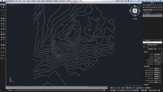
QGIS Exporting Contours to CAD(dxf)

HTML-код
- Опубликовано: 17 авг 2024
- This video is a demonstration on how to source elevation data online then create and export 5 meter contours to dxf.
timestamps
0:00 Start
0:43 Creating the project folders
1:36 Identifying the study area
1:40 Quickmapservices
3:00 Setting the project CRS
3:58 Creating the coordinate CSV table
7:41 Importing coordinates from a CSV
9:44 Creating a Geopackage
11:25 Exporting a layer to a Geopackage
13:05 Create a new geopackage layer
14:25 Snapping options
15:00 Editing a geopackage polylayer
16:51 Adding data from a Geopackage
19:50 Downloading a 30m SRTM DEM
23:02 Adding a raster layer
23:35 Clipping a raster layer with a mask layer
27:17 Extracting contours from a DEM
29:22 Exporting the project layers to dxf
32:34 Adding a dxf to QGIS
30m SRTM elevation data download link - dwtkns.com/srtm...
Requires registration at - urs.earthdata....
QGIS - qgis.org
Spatial Modelling Solutions - https//:smsgis.co.za


man that's some awesome global team-spirit to create a video as an answer to your students question and to then share it with the rest of us too. many thanks!
i m from turkey it is very hard way :) but thx you for your explain
hi, why Data Source Manager can't read my CSV properly; it can't read the X Y field
never mind, I have figured it out File Format>select "Regular expression delimiter" then entry expression as semicolon (;).
I think it has to be because of my system locale format.
Great. Happy that worked out.
Why can't I open the exported dxf file by autocad(it always shows some error and made autocad crash).Is it a bug of qgis or there is something wrong of my computer?
I had the same issue, when I saved it from the top menu Project - Import/Export - Export Project to DXF it worked, it doesn't if I do it from the layer - export as.. please try it
Hey guys, I had the same problem and what Stefano said was the solutions!
Dude, half this video is doing styles on layers and loading data in QGIS. If we're at this point, it means we already know about that. Just show us how to export layers to DXF and skip the unnecessary content. This should not be a 34 minute vid.
Point taken, I'll add some chapters / timestamps.
@@Qtips1 Thank you. Keep up the good work