Это видео недоступно.
Сожалеем об этом.
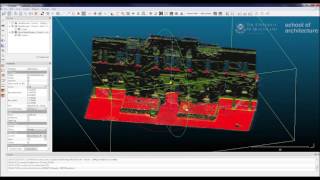
Cloud Compare tips

HTML-код
- Опубликовано: 18 фев 2018
- Stantec has certified drone pilots, and currently uses pix4D to photogrammetrically process point clouds from aerial photography.
This example shows the very simple Cloud-Compare processing tools to
remove vegetation
resample / simplify your point cloud
run contour plots


Excelente video....!!!
Thanks! great video!
master piece!
Nice video,thanks for sharing it. I would like to know though, if it is possible to display height values on those contour plots? I can remember from geography books, showing these kind of lines with altitude on the lines.
cloud compare is not the best place for formatted contours... best to learn how to do this in a GIS package like QGIS (shareware) or Global Mapper (paid)
@@LeeFluff thank you, I will check QGIS👍
Greetings, do you know how to generate volume estimates between two scans? I'm trying to scan two banks and measure the different between them with time.
You want to try the volume tool. Unfortunately it is only quasi-3D as the elevation difference between the surfaces is only measured vertically... so it does not work well with overhangs...
Hi, is only por point clouds? can i process with an image .TIF?
cloud compare is a 3D cloud editor... I presume you are talking about a geo-tiff surface... if you want to try and re-model that kind of input, then CC is not your tool... you are going to have to use some heavy GIS software work... not my specialty
Is it possible to save a project out of cloud compare that retains all your referenced files?
yes.... you can drag and drop all of your layers into an ordered tree structure in the DB Tree window... select the top of the file tree that contains all of the sub-layers and save this as a bin file to reopen in the future
Where do l find this plugin to download? I can see the page and read about it, but no apparent download.
plugin is already in there - just need to select the layer for it not to be greyed out - check out this example ruclips.net/video/ImJcvnEHYsw/видео.html
hi, do you have an email? thanks
I do, but I prefer not to give it out to people I dont know ... feel free to ask questions though - happy to answer them :)
@@LeeFluff i have a point cloud that i need to clean, i need paid help, please let me know if interested, my email jokey8852@gmail.com
thanks
@@rikimontano this is my process here: ruclips.net/video/ImJcvnEHYsw/видео.html - take a look at that and let me know if you still need help mate. :)