Vignelli’s map design was considered by design professionals to be “perfect”, but it did not meet the needs of the commuting masses. What are some other examples of things that have been heralded as “perfect” that were actually not as good as the “worse” thing they were replacing?
Apple releasing an iPhone without a physical headphone connector, eschewing it for a "solution" which drains battery faster, is glitchy (will introduce unwanted drops/skips in audio) and, drum roll please... doesn't even SOUND as good as an "old-fashioned" 3.5mm jack. Dumbest design decision Of. The. Decade.
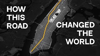
Living in New York for a decade now, i've thought a lot about this. It's all about the street grid. New York's famous grid is the spacetime ether in which Manhattan exists. Locations are known by their avenue and their street. "8th ave and 14th street" is a 2-dimensional address that any New Yorker and most visitors can immediately find on a map. The problem for a subway map designer is this street grid is very unforgiving to distortions in the diagram. It really, really matters that stops along 7th avenue appear west of stops along 5th avenue. They're considered more or less different neighborhoods in such a tight, dense city. London doesn't have this issue because it's a medieval city with a cacophony of crooked streets. But in New York, any diagram that doesn't play nice with the street grid (and offer labels for the streets) is bound to fail.
The Bay Area Rapid Transit (BART) solved this by having two maps - a diagramatic one for quickly finding your way, and a geographic map so you know where you are outside the system....
Yeah, that's a common solution. They show the Montréal diagram (which is geographically very distorted) on the video above, and in the Montréal Métro, it's the map you see everywhere (it's freely available in small pamphlet form for tourists as well). But every metro station has one or two (minimum) full maps of the island of Montréal and surrounding area, geographically-accurate and including all STM (Société de transport de Montréal) line information (both metro and bus lines for the whole island). And if you're downtown, there is a geographically-accurate map focused just on the downtown area, giving a lot of detail that's hard to read on the larger map. So if you don't know where you are, or how to get to where you want to go...it's easy to figure out. And if you do know where you're going, the simplified diagram allows you to track your trip with ease. That kind of dual system would make a lot of sense for NYC. What would make MORE sense is to invest a few billion dollars into making the NYC subway system less INSANE (also, more convenient and comfortable...but less insane is a good start).
Yeah, having ridden BART for many years, I was thinking about that. I prefer the BART diagram over the map, so I understand why he made this diagram. The Paris Metro has the same thing: a diagram, not a map. Works great. What the video makers imply, but don't seem to state, is that waiting many decades to introduce this diagram meant New Yorkers were used to the more representational maps, and wanted that in the unified system. The diagrams were introduced nearly 100 years ago, as she points out. So a lot of it may just be what New Yorkers are used to.
They did a beautifully illustrated 'overground' map for the Piccadilly line in London. They were posted in the carriages alongside the familiar diagrams and, for me at least, brought to life what was going on above as I traveled between my stops. But they never did it for any of the other lines.
The Beck diagram doesn't work for NYC because in most other cities you walk to the nearest stop and take the train to the stop nearest to your destination; in NYC you think about which train/line to take because transfers are often hard to impossible because they were built by competing companies. In most cities subway traffic is funnelled through hubs where you switch trains; in NYC you have to choose which train to take before you even decide which station to go to. It's often better to walk an extra few blocks to take the train which gets you closer to your destination. This means that the surface geography/grid is totally relevant to your decision on which transit option to take.
Yeah I gotta agree, the geographic locations of each stop are super important, especially if you want to know where you'll end up and how close you are to notable land marks. Idk i like the current map
That explains why the Beck style map doesn’t work in New York, because there are no hubs. In London, all lines cross all other lines. Transferring is easy. Two trains is the maximum you need, you can get anywhere without leaving the system. In Melbourne, they all feed into the same underground loop. You can get to Any other line by taking an escalator to a different platform. Or just waiting on the same platform. Central planning at the design stage made this possible. New York had three separate systems, so therefore had three central plans. They were never designed to work together.
Competing companies isn't the only reason. Another is that most lines in NYC go thru Manhattan longitudinally: either Queens-Manhattan-Brooklyn or Bronx-Manhattan-Brooklyn. There's only a single G train that's Brooklyn-Queens. This means that, say, if you're going from midtown to downtown Brooklyn, there are loads of lines that do mostly the same job, and you can't transfer between them. You choose the line that has stations closest both to where you're coming from and where you want to go.
Ascdren of course, except much of the London system was built after they were unified, and those who developed the original lines didn’t design it to make transferring difficult. They functioned more like a cartel before they became a monopoly, mostly. And where there was cutthroat competition, once one company went out of business,it was taken over and annexed by another, and this happened while the system was still developing. But this didn’t happen in New York, they had three separate systems that didn’t unify until long after they stopped developing.
Montreal has few lanes. Moscow is a clusterfuck but is zoomed out to low information density. Tokyo just goes "MUST CONSERVE PAPER" and doesn't leave any space.
My friend was so lost and nearly tried to go in the wrong direction. She eventually gave up and let me navigate. To be fair, she struggles with maps in general. I typically navigate for us whenever we go anyway (I enjoy using maps). Not that we were on the Tube for all that long anyway. We were only in London for a day. We spent most of our 4 day trip in the UK in Manchester. I found DC's map much more confusing. I think it's because like most US cities, DC is laid out like a grid whereas London grew up pretty much organically and thus doesn't have the same grid pattern to it's streets and neighborhoods. So the distortion of DC's geography really fucked with my perception of where I was and where I was heading. I still managed okay, but I ended up walking a lot more than I expected to. It was just easier to use Google maps to keep an eye on where I was and where I was going instead of using the buses or subway. I was with a different group on that trip and they quickly shifted to letting me plan the trips. lol BTW, I'm not slighting women's navigational skills. I'm also a woman. The group I was with in DC were mostly men and they couldn't figure out the maps for the life of them!
@@EdJonesVideos There actually are a couple of "express" sections, they just aren't identified as such (Piccadilly between Hammersmith and Acton Town, and Metropolitan between Wembley Park and Baker Street).
I'm from NYC and I loved the map they use. I find it very clear and helpful for me to find actual locations. For example, if I know the address of a particular store, I can see how far it is in actuality from the nearest subway stations.
tldr: everywhere else uses diagrams and its good enough for them this diagram for new york's subway system is so good and artistic new yorkers hated it because it wasn't good enough for them *end of video* everyone in comments: "well yeah because they literally wanted a map so that they can see where they're popping in/out, whoever said we don't need to know where we are geographically is an idiot"
GameWorks12 that’s because RUclips introduced that BS where you have to literally pump out more BS to get paid more for the ads that run on your film.... just straight up BS 😆
It doesn’t really matter though. The purpose of the thing is to help users navigate the subway. If it doesn’t do that then it’s a bad design. Getting lost in the semantics of “diagram” vs. “map” is how bad products get designed in the first place, and “you’re using it wrong” is never the correct response to a bad design.
Luke Downey I do understand but, I personally live in NYC and I can not stress enough that the map can be a little hard to see or read for new comers, however, if you know where you want to end up, it is very useful to see where the location you're trying to get to is visually displayed on the map rather than you being completely oblivious to where you would end up which was the main problem that the new (current) map fixed.
@@robbyday1532 Every year more meanings are added to words than words are added to dictionaries, but that doesn't negate the previous meanings. The present generation utilizes the newer meanings where as the previous generations utilize the older ones.
I'm very familiar with the Boston map, and when I moved there in Grad School, I had no problems navigating with it. But when I started actually walking around the city, I was shocked by how close to each other many stations on the map actually were. A geographical map would have actually saved me time by taking me to a close station and avoiding unnecessary transfers.
But every Boston T station also has a geographic map. I like the simple map. It shows me how long the line is and where stops cross with other lines. You make rough decisions to p k a stop from geographic maps, and use the simple one to know how far until your stop and which direction to go.
I certainly haven't read all the comments, but I've read many and am surprised that no one mentions the fact that NYC is a numbered grid in Manhattan and mostly a grid elsewhere, whereas European cities are a drunken spiders web of streets. With a numbered grid, you know that 59th street is south of 65th. And if your cartoon subway diagram suggests it isn't, THAT's an inherent problem. I have been in a dozen subways in Europe and many times in NYC and I have no problem figuring out either system of maps/diagrams. But I found the NYC diagram experiment absolutely hideous. I would say that it's a map designed just for tourists except that apparently it confused tourists, too. So it was a failure. Another problem with the diagram's lack of connection to geographical reality is that there is no easy way to know if two subway stops are within easy walking distance of one another. Londoners love to laugh at tourists who spend 45 minutes underground and make two transfers in order to get between two stations that would have been a 10-minute walk apart above ground. Well, there is a reason why people make this mistake; because the precious tube map makes it look like a good choice. That is a map-making mistake Londoners have learned to avoid by knowing each neighborhood in relation to its tube stop. But New Yorkers think in relation to their city as a whole, and its easy to navigate, numbered grid of streets. Any diagram that suggested 110th street wasn't far from 65th would be a poor diagram.
nannyg666 that's not the issue of the London DIAGRAM, that is an issue with someone using it as a map. Any simple map on your phone (or paper) would help you understand how far above ground you need to go. If you need to use an underground train map for your above ground journey, you really need to think twice. London map works for what it is, a map of the tube. NYC map works as a general one which makes the locals feel good.
My favorite comment. So I am replying to this one as a contribution. There are multiple options to go to the same neighborhood. Especially over the weekends you may have to forget about your regular subway line and find an alternative line with a close-enough stop. In that case diagram matching the “map” matters a lot. Also no matter how fancy your design is, New Yorker’s are all about efficiency and utility.
that's something i don't get at all, why the fuck there's still 10 stops in a single "grid" even after the city take control of the subway. Where I from, Hong Kong, it was must simple, there's 1 stop in every "district", you arrive the district and get to a secondary transport system, either tram or bus or walking are all accessible, and that's it.
This comment makes the most sense so far. I can see how morphing a spider web of roads in my mind to match a diagram would be mentally easier than a grid system that labels streets based on location.
I actually came of age and learned the entire NYC Subway system using the Vignelli Map. It was the only subway map that I could get my hands on in 1976. I could never trust it when it came to actual city locations, for that I had a Hagstrom or Rand McNally handy, but it did show the entire length of subway lines and where transfers could be made. When the Vignelli map was replaced I was more than pleased.
Tom Scott did a video showing how if you want to go from Lancaster Gate to Paddington station, the subway lines take you on a massive detour that the system diagram doesn't clearly depict, so it's easier and faster to just walk through the streets of London.
@@akarshrastogi3682 Many reasons: 1) You can't get there by subway. 2) It reeks of suburbia. 3) It's basically NJ (look at a map; count the bridges). 4) They're politically different from all of their neighbors 5) The British. 6) It's fun. We still love them though. And before you ask, we disparage NJ because: 1) We have to share the river and the port and a ton of infrastructure with them instead of just owning the whole thing. 2) They obviously wish they were NY, and we want them to be NY, but they're not. 3) The British. It's literally their fault for deciding on a dumb border. 4) It's fun. We love them too. Actually, we love them more than Staten Island.
The new map was a good try, but as everyone says, it took too much context away. It was too reductive. The map would've been pretty okay with some slight geographic distortion, as long as it included above ground information and didnt go too heavy on the abstraction. It needed place names, an accurate central park, relative cardinal positions. But expanding the downtown core and shrinking the outliers I can excuse.
Look at the London map, yes the zone 1 and 2 stops are out of proportion to the rest of the map, but they haven't moved the Green Park stop a mile or two west of where it actually is...
I think an additional problem was that the Vignelli's map was cluttered with the rainbow of colors the MTA had previously introduces (purple, black, yellow on the Lex; red, orange, yellow, green on the Broadway line) . The updated version (released for the SAS opening) is much cleaner with each trunk line having the same color for all routes.
I think that's a real issue with the Vignelli map - it's hard to follow lines because colors repeat and trunks are rainbows. Compare the Weekender or Kick Map, etc that are contemporary versions and they function easier.
My city, Toronto, uses a simplified and distorted subway map diagram, similar to London's, but we also publish a more detailed "Ride Guide" that includes surface routes and uses a proper map with streets marked on it. The best of both worlds.
In case anyone is interested in seeing Toronto's two maps: transit.toronto.on.ca/archives/maps/ttc-2015-subway-map.jpg transit.toronto.on.ca/archives/maps/ttc-rideguide-20180902.pdf Note the extreme vertical distortion and the even horizontal spacing of stations on the subway diagram vs the actual map.
Spencer Martin Navarra Chew Interesting maps. Thanks! I have a question about Toronto Subway, how extensive is it, and how well does it manage to cover access into multiple neighborhoods? For example, NY & London have stations, 2-3 minutes from each other. I’ve traveled in both extensively, never been to Toronto hence my curiosity.
@@jewslikefunk Toronto's subway is too small to be considered a stand-alone entity. The stop frequency is there, but the line density is insufficient to service everywhere, except for parts of the downtown core. That's why it's fully part of the rest of the TTC: buses and streetcars; the same ticket pays for all of it, meaning you can freely transfer to or from any part of it. It really consists of two core lines crossing and radiating from the downtown area, and a few short ones on the periphery. Honestly, you can think of it as the "express" line for the TTC streetcar and bus system. One of the major issues with it is that the core area is under-serviced. Given passenger volume and accessibility, we most need another line in the downtown area, which a number of studies have shown. However, it's not as politically advantageous to propose a new line there, so it probably won't happen for some time.
I've used both the NYC and London Subway maps extensively. The NYC map worked best for me when I lived in New York as it helped me find the best route to things where walking was a frequent option. The London map doesn't have much distortion close to the city center so it works great there. As you venture further from the city center though walking is less of an option and simply knowing what stop is connected to what line is fine. As any cartographer will tell you, the "best" map depends on what you'll be using it for.
@Gabriel How does that make Chicago trashy? All the city's streets are set up as a grid that branches out from downtown, with Lake Michigan as the eastern terminus, while the lines of the CTA are also centered around downtown (AKA the loop) and they only go in straight (north-south, east-west) or diagonal (45°) lines, making the system perfect for the type of diagram the video is referring to. Idk how that makes Chicago trashy. Like, I know the city has it's problems, and while your conclusion may or may not be correct, your argument still makes no sense.
I would prefer the more accurate map, but concede that it might actually be nice to have both! Like... flip it over and see a simplified version, right?
So the funny thing is that this is what Massimo Vignelli envisioned. Have the simplified map, and the geographical map on the same map, but have them on different sides, but of course something got lost along the way...
None of you fools realize that subway maps are bolted to the wall, you can't exactly flip it over. Stop acting like having a flip over map is common sense when it doesn't fucking work
As someone from New York who has been using the "complicated" map design my whole life, it's difficult to see why anyone would ever prefer the simplified version. It's rarely the case that the train takes you exactly where you want to go. Trains often have delays or skip stops and you need to be aware of the actual above ground location of the different stops on the different lines to be able to quickly adjust your route to get where you want to go. Even without delays, there's walking distance involved for the final steps and so using a simplified map gives you no information on which stop is actually closer to your final destination once you add in the walk.
@@PatheticTV Yeah but those just are confusing and huge systems. This is unlike NYC, where in Manhattan, almost every train shares a tunnel with another train, making it easiest to just show different trains with the same color. Outside of Manhattan? Still not a problem as the subways outside of Manhattan don't have a lot of trains close to each other.
@@FrostyNut You would be surprised. I've lived in NYC my whole life, yet there are places I've hardly ever been. I haven't had the need or desire to go into Manhattan in years. The Bronx is like a foreign country to me. I know some parts of Brooklyn and other parts are a complete mystery to me. Yet sometimes we have to go to a certain place for some reason and the question becomes, "What's the best way to get there?" and that's why the Vignelli map falls flat on its face with its spaghetti of different colors, letters and numbers (IRT lines are numbers, BMT and IND lines are letters, single letters for express trains, double letters for local trains, etc.) and especially no references to any above-ground landmarks.
Back in 1975 I went on a class trip to NYC and I picked up a copy of the Vignelli map/diagram. I wish I was able to keep it; it would be worth a lot today.
Mine has an entire cottage industry of civil engineering firms constantly producing studies on viability of subway construction for the local gov't. We'll never be able to afford actually building it.
Good design is "form meets function". While Vignelli's map was easy on the eye, it did not serve the purpose of navigating the city in its entirety. Fun fact, our current NYC subway map is not geologically accurate as well. If one were to look at google maps, the island of Manhattan is much narrower and lays 29 degrees from true north . It was deliberately skewed horizontally to squeeze in more information and text. It is just more acceptable than Vignelli's version.
Expanding the island to fit more information is acceptable since it makes the map better at letting you navigate the area, as a map should. The map appears less accurate, despite being more complete and useful.
@Art account IT unless your starting point and destinations are right next to the station and theres no transit involved in between, otherwise the whole actual map is needed.
When I first visited NYC in 2008 (back when smartphones weren't a thing), the subway's geographic map helped a lot when we wanted to find landmarks and places to go. So it's a really good tourist map.
NYC needs a geographic map because here in New York, people don't just use the subway map to navigate the subway, they use it to navigate the entire city.
I got to agree with you live90. I had use the map of NYC and subway all together in 1 map for travelling as a tourist. It is a genius to use geographic map for NYC.
but should they? I've never used the subway map to navigate the City. Even the geography-preferring NYC map at present isn't useful for navigating geography AND people think it's hard to read.
I know from personal experience, attempting to traverse a city you're not familiar with - especially while using public transit - can be exceptionally daunting. You want to get off at a spot in which you know you'll be within walking distance of your destination and if the map you're reading doesn't accurately reflect that, it could leave you a good distance from where you wanted to be in a city you're just simply not familiar with.
I've been confused by a quite a few public transtport systems recently (Berlin, Lisbon, Budapest, Paris), so I consider myself an expert in how to get lost despite looking at the map :) I guess there are 2 competing goals: If you know the city and know where you want to go, the simplified map is easier to use, because you get the most important information directly: Which lines go where directly, and where can you switch lines. But as a casual subway rider who does not need to optimize a commute and just wants to get from point A above ground to somewhere near point B above ground, a geographically correct map with an overlay of streets does a better job.
I find this so interesting. Having grown up so close to NYC and using the subway, I looked at that Vignelli map and immediately hated it. But I've also traveled to many major cities like Moscow, London, Tokyo, and Paris, and I've enjoyed the simplicity of their metro maps. I wonder if it's because I've grown up with the current NYC map, or also because there is just so much more going on in NY between each stop compared to all of these other cities.
it's because you're used to it. If they would have stuck with vignielli's map for a couple more years, new york would have had a decent map now. Change is hard, I get it, but generations of unnoticed confusion is at stake...
Correct me if I'm wrong but maybe New Yorkers are very particular and proud of NYC's geography? Any book, movie or show set there references locations and streets as if anyone on Earth knows its culture. Different regions of the city are treated like they're foreign nations. The sheer volume of media about the city probably compounds that. If that's correct then a map that distorts that geography, even for ease of use, would probably irritate New Yorkers.
I've been going to school here since august, and coming from St. Louis, Missouri, where the MetroLink is two squiggly lines that run together most of the way and is the most useless thing ever, I was able to intuitively use the MTA to navigate and not get lost once. The moment I looked at the Vignelli map, I was confused, and could see how I could get lost so easily there.
I also grew up in NYC and I also hate the Vignelli map. I think it's a combination of several things. 1) we are not familiar with it so we dislike it on principle. And 2) Vignelli left out the streets, and we navigate primarily based on where we're going above ground. So without streets on the map it's difficult to figure out which stop is closest to you and which stop is closest to where you're going simply at a glance. And especially since the geography is so distorted you have basically no hope of getting that information at all just from the map, let alone quickly. Plus the subway in NYC already largely follows the streets, so people tend to use that to navigate. Removing that information is just silly for NYC, where the streets and subways are so closely linked. 3) his map is very simple but it's also not actually easily parsable since it's got lines running next to each other with no gaps, and many different colors. If you look at the other maps the video mentions that all have significantly more negative space between pieces of information. It might be easy to look at but it's hard to read even if you know exactly where you are going.
@@nydydn I disagree. I've never been to New York. I have however been to places like Berlin, Paris and London. For those cities the maps work, for New York Vignelli map seems awful.
I remember one time when I was in Singapore and was walking from one area to another and it was an extremely long walk that I struggled at. I later got onto the subway(or whatever it's called there) and those two areas were right next to each other in the map...
@@SamanthaVimes Most people do basic research beforehand and use a real map if they want a real map (very easy to do nowadays). Transit maps are for finding your way around the tranist system in most places, not planning your entire journey A to B, it's not that astonishing. I've been to London as a tourist with no local knowledge and it's not difficult to find which stations you need to go to. The simplicity makes navigating the complex network easier.
In many US transit system, the names of stations are mostly based on street names, not neighborhoods. It makes these simplified maps unusable because of the inherent geographic association with stations and street names. You need to know the station's relation to the street above to navigate, especially since there are multiple stations with the same name. There are 4 different freaking 86th street stations. This is why an accurate geographic map is needed in cities like NYC. If we look at Tokyo or Hong Kong, the stations are named after neighborhoods, wards, and landmarks. You don't need to know the exact geographic locations because the street address above are completely divorced from from the train network. You take the subway to a neighborhood station, then you take the tunnel/bridge exits with signs pointing to major landmarks to go to street level. Geographically accurate maps of the station's surrounding will help you find more exact location if you need it. The beauty of these systems in Tokyo, Hong Kong, and many others around the world is every district and neighborhood is compartmentalized. You don't need to know to geography of the entire city to navigate. You won't get lost, even if you never look at a street map.
As Hong Konger, we are very proud of our metro system 🙏🏻 Having also live in New York City before, I also completely see how the geography distorted maps don't work there. It's sad because it shows terrible the New York subway system is
Almost every LA Metro stop is named for an intersection. they use some simplification and distortion but do vary distance to give you an idea when it's a long haul between stops, for instance, between Hollywood/Highland and Universal City on the Red Line (the latter being one of the few exceptions)
Station names that make it easy to find where you're going on a make definitely helped with what little navigating Tokyo I did when I wasn't traversing the giant train track circle called the Yamanote Line. Having a map of the city available is also very much necessary for navigating overall. People still need to translate the station name to a location on the surface. That's something the maker of the New York map didn't seem to grasp.
I would argue that the Vignelli map failed because it learned the wrong lessons from Beck's map. Vignelli failed to make his map simple to read: the spaghetti rainbows of branching services are more confusing than any other design applied to New York. The geography is compressed, but not in ways that clarify anything; the most dense portions of the network (Midtown, Downtown, Astoria, Brooklyn Heights) are more difficult to understand than ever. Unlike London (which is far deeper, on average), New York's lines already intersect at relatively neat angles (running closer to rectilinear streets) and twist far less. The 1958 map by George Salomon was far simpler to read, used fewer colors, and made similar, but more intuitive geographic alterations.
static01.nyt.com/images/2008/04/30/nyregion/Vignelli-Subway_FINAL.jpg Here's a more recent interpretation (excludes the 7 and Q train extensions) that uses the colours the current map uses based on trunk lines.
Even that simplified version is still very busy where it might be simplified. Multiple lines that run parallel could be merged, with bifurcation only where they go along separate routes. Intersection points are not clearly marked and so you can't work out where train changes are possible. I had a look at the George Saloman map mentioned above, and as a stranger in NYC I'd probably be happier working with something evolved from that. archive.doobybrain.com/2014/01/01/1958-nyc-subway-map-diagram-george-salomon/
@John Flahertynot sure I follow. The cleanest example I can think of is the Metropolitan line on the London Underground (top left of the map). It splits at Moor Park and Harrow-on-the-Hill, but remains the same width throughout. What I hadn't appreciated with NYC is that trains skip stations on the shared lines (route letters), and that the map tries to show this level of detail.
@John Flaherty in London all the stations where it is merged still only have one platform going each direction. The boards showing the arrivals will have the trains final destination on them so travellers can easily check if it will be going the correct way for them.
In London, the early maps were geographically accurate, but finding out where to change lines was almost impossible. Harry Beck's solution was so brilliantly simple, he emphasised not so much where the lines were, but finding the connections between them, where you can change trains to carry on your journey. To say it was a transport revolution is an understatement
New Yorkers wanted/needed a map. What they got was a diagram, NOT a map. This pissed off New Yorkers who needed to know where a stop was IN RELATION to the streets above.
This sounds quite vague. Then how come eminent amount of the cities around the world chose to change to diaram? With what New York was different from other large cities? I think that the seperate metro company competing with one another theory seems way more plausible that was suggested by Marisa Lau in this comment section.
@@artursbalodis9360 NYC is just already so navigable, I'll be anywhere in NYC and if you ask me to go somewhere, as long as I now the address, I'll get there.
@@artursbalodis9360 What are you even talking about? Diagrams are for navigating from subway stop to subway stop. Maps are for navigating from subway stop to landmark. Someone makes a comment about the contextual utility of maps over diagrams, and you just vomit up this nonsense about "But muh diagrams!"....WHY is it so hard to understand that diagrams are more useful when you can ignore surface geography, and maps are more useful when surface geography matters? It's like half the people commenting are autistic.
@@artursbalodis9360 Different cultures, different tastes? I feel like knowing exactly where each stop is above ground is more beneficial than whatever ridiculous reasoning is behind the diagrams.
@@artursbalodis9360 1. Maybe in other cities noone bothered to ask people what they want? 2. Maybe in other cities people dont need to have spatial information and know exact relation between underground and what is above the surface? 3. Maybe because this is not a map but diagram and New Yorkers needed a map? I travel and this diagrams are useless to me. If I need to know how to get a connection I need a map. I need to know exactly how far some stop is from the place I need to get to. Those praised diagrams are useless for this purpose. To me the praise of this diagrams is done by people who dont use it. Circlejerk praise.
As a german who has been to Berlin a few times, I always wished for a geographically accurate subway map. These stylised maps are really appealing, and if you know the geography of the City and where all the stops really are, its nice ( but at that point you might as well know all the lines and wont need a map at all). But if you dont (like me), its a nightmare.
@Felix Nensch Da stimme ich zu. Wenn ich mit der S-Bahn nach Wannsee fahre will ich nicht auf der Karte sehen wie die Bahn eine halbe Ewigkeit durch den Grunewald fährt
I rly like the distorted diagrams. Because it makes understanding the system and where you need to go so simple. Obviously you need to know which stop you wanna get to. But as soon as you know where you are and when you wanna get to. The diagram filters out all the unnecessary information making it a lot easier to read.
It is beautiful!!! It just doesn't show stops in reference to location. Which is really, really important for NonNew Yorkers who need those references points.
But if it says the name of the stop then the you can easily understand were it is! For example on the tube there is Westminster station, guess where it is Westminster! Or London Bridge guess where that’s near, London Bridge. Just name the stations probably and it’s easy
As a New Yorker, I'll take my 'overcomplicated' map with landmarks, important avenues marked, bus transfer options at important stops actual useful information. It's fine the way it is, I prefer my geographically correct map so i can calculate my distance place to place better.
Axel HZ as a tourist I say the geographic map is horrible to understand however I would still pick that one for New York only simply cause your station names are so similar and confusing that it makes not using geographic reference on the normal other map really difficult
@@mikemy100 this map is easy to understand if you think about it in the way it was made for actual geographic reference when it comes to the stops and line. That's how we see it nor we don't complain about getting a new map
The real difference seems to be that your subway system doesn't do nearly as much as the London one. In London the Tube is so important that stations ARE the landmarks, avenues aren't important, and buses are mostly for places outside the network. You almost certainly know which station you want before you check the map because it's given out along with addresses. All the Underground map needs to tell you is how to get from the first station you see to any other station on the map in the smallest possible number of stops.
I've visited New York for a week and it was super fun and people where way nicer then I thought they where going to be. But I found the system really confusing. I'll give you an example I wanted to check out the MET which is in Central Park, okay fine now imagine my confusion when I get there and can find the MET because I ended up on the wrong side of the park. Then again I'm from West Virginia where almost everyone drives.
And I've looked at enough above ground maps of Manhattan that the new map *instantly* gave me an understanding of the real routes and how they go to the Bronx or Queens, etc. Which is why I agree with the residents.
In Shanghai the map is distorted. It is fast and easy to figure out where you need to go and what transfers to make. I mean when we communicate where things are often we talk in terms of metro lines.
To be fair, I woudn't prefer one type of map over the other, I'd like both side by side, with same reading indication and graphics. We have that in Paris metro and I am perfectly OK with that way of thinking. But I think when the city area is very big and the transportation system very heavy, a schematic map is better for reading it, as long you have a geograpically accurate map beside to really see where you're going. Smartphone applications can do that really well.
I agree you need both. I use mostly my smartphone to pinpoint the stops or the geographic map and then the simplified to plan it with the underground system
Many people don’t seem to understand the difference between a map and a diagram. In London you use the Tube diagram to find your way on the Tube and an A -Z to find your any on the surface.
impressive. in London you find out the nearest stops before you travel then consult the map. New Yorkers seem to want a subway map that shows them the nearest stop to their destination which is not really how a subway map should work.
I would add that the London Tube diagram works at at a second level: how to use the train that you're currently travelling on. Each train has a more specific diagram that covers places that only this train will go (a single colour line), and indicating both main transfer points and local route idiosyncrasies too complex to put onto the main map. One of the main difficulties I've seen for visitors to London is identifying the correct train where two or more lines share the same platform. You can get very disoriented very quickly because of the backtrack required.
@@IanJefferies Yeah the "identifying the correct train" on the circle/hammersmith & city/district/metropolitan line scenario is often confusing for visitors, but it was greatly alleviated when they started colour coding the internals of the trains themselves. In NYC, meanwhile, if you get on a train that is on a "yellow line" that happens to be the wrong letter it could easily skip the station you need (actually passing straight through it) and, for visitors, can be confusing as heck.
@@alanmichael5619 while I've not been on the NYC transit system I can see how that would present a challenge and a surprise. The London Underground equivalent I'm most familiar with is the Metropolitan line with its fast trains that bypass stations - these are clearly signed on the single line map within the train itself, but don't clutter the main map. The current NYC map (courtesy of CityMapper) has a very high information density along the route lines (letters and numbers), and there are also route changes marked for both day/late night and weekend services.
The diagram style maps help you when you already know what stop you're getting off on. The other style is more useful when you are trying to figure out which stop to take. So maybe have the scale version near the entrance and the other version underground and on the trains themselves.
I feel like the grid layout of the streets may have also contributed to the problem. Everybody navigates using streets and avenues like coordinates. When the stations are moved around on the map that much it's a problem.
I can handle the diagramatic map of my _own_ city's subway. But when I'm using transit in another city, it's a pain-in-the-tuchus having to juggle a regular map and a subway map. First you need to hunt down where a destination physically is; then corelate it with the nearest s.w. station - which is plotted on a distorted grid that _lies to you!_
One huge benefit of the diagram solution is that you can even out the information and avoid large gaps of nothing in certain areas, or untangle very condensed areas like Zone 1 of London. Also note that map solution can retain accuracy especially in cities that does not expand so much (cities on coasts or islands). It might have been easy enough to make a London tube map in the 30s with excellent geographic accuracy, but it’s impossible now that we have lots more zones.
In NYC we need to see those large gaps of nothing. It could be the difference of getting off at a stop that is 1 block away from your destination or 5. Additionally most stops are named after the street. On 86th street there are FOUR stops called 86th street, which all let you off at different intersections. If you can't relate it to the above ground map you have no idea how far down the street you actually are going.
@@DoomFinger511 My guess is that its not acctually that other cities dont have the gaps and you could get off completly wrong there too but that outside of north america cities arent based on a grid design so people can just say that this street is next to the other because of the name they acctually have to know which street is where how long it is and where the stop is instead of thinking first street musst be next to second street and so on. So people in europe have to look up where they are going anyway and find the nearest stop not based on assumptions.
Tobias Kirsch I agree, gaps aren’t unique to New York, and it’s more about NY streets largely named by numbers. Outside of Manhattan will need some map shrinking in favour of diagram as it extends further, and street alignment is less of an issue.
@@tenkdkme You're correct, except that it isn't just a north american thing. It's strictly a NYC thing. In other cities like DC the diagram map works fine. In a grid city like NYC every street is several miles long so just the name doesn't help.
@@DoomFinger511 Yeah bad wording from my side. Wanted to say that without a grid system its nearly imposible to have the same thing happening, so it is something that could happen only in north america since as far as i know know other continent realy has such grid style layouts and not that it must happen because of a grid layout but that it only can happen with a grid system
I am actually born and raised in NYC and I find Vignelli's map so confusing. New Yorkers are pretty much raisef with a sense of neighborhoods in their mind. Like I'm from Queens and I can already divided all the neighborhoods in my head based off of the location, style of building, is it near the shore, is there park, what ethnicity lives there Etc. Where we want to go definitely depends on what's above ground especially with Queens you can't rely on an address because its not on a grid system.
The New York Subway lines are as dense as tram lines in other cities. This as well applies to distances between stops. So your choice of line and stop really depends on the what's above ground than what's underground. As Marisa Lau said down below: you may decide to walk a block and take another line or to get off the train close to your destination and walk a bit than making a transfer and getting off exactly at the point. And BTW: The subway map was the only map I had during my 1st visit of New York City in 1996. And it was fully sufficient.
In my opinion the distorted map is much easier to figure out where to change lines to get from one place to another one, particularly in a complicated network like in NYC, while the geographically accurate one is easier to understand where the stations are, where to get in or out. Ideal would be to have both.
New York really is unique. In practically all of the world's cities, the Beck map is far superior--perhaps even so for NY's suburban railroads. But for the city subway, only a geographically accurate map can help one navigate the cluster of neighborhoods and commercial districts in each of the five boroughs.
They have this in Berlin. Usually in an U-Bahn station, they'll have the simplified map for when you're changing stations, and a geographically accurate map for when you leave the station or change to a bus line.
I still don’t understand why people prefer diagrams. With more accurate maps like the one in NY you can actually see where you are located in the city with respect to streets, parks, landmarks, etc. What is the confusion with geographical maps if they have the same lines and stations as the diagram but with the real placement over the city map and more accurate scale?
@@byrlink The advantage of a diagram is that it unclutters the structure of the network. It makes it easier to see where you can or cannot change lines. Visually it is easier to understand the structure at once. Especially in New York, where there are so many lines and connections between the lines. Think of a first time visitor trying to find out which combination of trains they can use.
I think there's room for an in-between approach, wherein you can tell by looking at the map whether two stops are close together or far apart, without the actual distance being actually to scale; a design where it's possible to tell what neighborhood is above ground at a given stop, and major things like where the coastlines are, without the individual streets being marked; a design where most of the subway line's twists and turns are straightened out, but the overall direction of each section of each line is at least approximately the same as what is depicted.
The simplified map is easier to get a grasp on if the system isn't too overly complex. DC Metro (years ago when I was there) was very easy to figure out with it's simplified map. I was able to master that system in about a day and was super confident in being able to get anywhere. Plus with things not being to scale it all fit easily on a page. NYC might just be a bit too complex for this simplification.
Zach Gravatt I think he’s saying since the NYC map is so complex and full of information, simplifying it so greatly is not achievable without cutting out information New Yorkers want.
How stations are name also make a huge difference. Diagram maps will never work for NYC purely because of how stations are named. DC stations are named after landmarks and neighborhoods. If you know you're going to that neighborhood or that landmark, the exact geography doesn't matter. If you're unfamiliar with the neighborhood, then you can find more detailed map at the station. Same with more complex subway/metro system like Tokyo or Hong Kong. The stations and lines are distinctly named. It is hard to get lost within the system. Navigating the streets after you exited the station is another story. In NYC, you have multiple stations with the same names and practically every stop is named after a street. They get mixed up very easily. So you need an geographically exact map to plan your trip. If say, you want to goes Hell's Kitchen in NYC, you need to know the exact location of the neighborhood on the map to find the station you need to get off of.
@@adayforgotten It's a grid. For example, the Apple Store on Fifth Avenue is located between 59th and 58th Streets. I can take the N R or W which runs on the 60th St Line to the Fifth Avenue station which is located on Fifth Avenue and 60th St and walk a block. If I want to walk a little more to avoid a transfer, I can take…: >the 456 which runs on the Lexington Ave line and get off at 59 St-Lexington Ave and walk three blocks west. >The F which runs on the Sixth Avenue line and get off at 57th St and walk a block east.
Meanwhile in DC, we get a map that's pretty but completely useless for answering a question like "which stop is closest to [intersection?" or "which route and/or transfer is actually the fastest way to get from here to there?" We have all sorts of instances where the line on the map may appear shorter, but the actual transit time can be much longer. But at least it's pretty and color-coordinated!
I think both types of map have their place. I feel the geographical design should be used for handouts and adverts, while Beck's diagram should be used on stations. Allow travellers to see both sides!
@@zebedeesummers4413 No one uses print maps anymore. They use their phone or the maps posted in the subway. I guess I have seen tourists with maps, but watching confused and lost tourists is part of the MTA entertainment.
Exactly. Both have their uses. I always felt that these more stylized maps were better for seeing how the different lines move relative to each other while more detailed maps are better for seeing exactly where the stations are.
Both has their use. A simplified diagram should be use in compact spaces like above the train doors to remind people what stop to get off, but a larger geographically accurate map should be available to use on large signs on stations for people to help plan their route.
@grimm@@ArchOfWinter Would be really nice if map apps (like Google, Waze, Nav and the like) had a toggle or for subways. Then just let the user chose or switch back/forth if they care to. Although people visiting wouldn't be as amusing.
I think the main issue with Vignelli's approach as applied to New York is that NYC's subway has *so* many lines converging into a single tunnel in Manhattan. In order to depict them as distinct continuous lines, he ended up having to turn the busy Manhattan tunnels into these multi-lane monstrosities of jumbled colors, which in turn pushed other map details out to the sides. The main local analogue I can think of is Boston's Green Line trolleys, where four lines converge into a single trunk downtown--and the MBTA "spider map" doesn't show the converged line between Copley and Lechmere as four parallel lines (though some of the Green Line-specific diagrams in the stations actually do). That does lose some information, because the BCDE branch trolleys don't all go equal distances to the other end of the line. But it makes the map less daunting to look at. Vignelli might have made a more London Underground-inspired approach work for New York just by doing what the current map does and depicting those downtown tunnels as a single line with branches further out. Yes, you lose some information about the subway trains, but it makes the diagram visually simpler and requires somewhat less distortion of the geography.
Matt McIrvin well; wasington d c s subway map has 3 lines that function as branches. They are in one tunnel through most of city proper. People egt arpund fine.
Very much agree, and something about the way the helixing of the lines downtown works is really unpleasant in his map. I think the current subway map is much more minimalist in comparison, And honestly is not to scale either, it just isn’t as loose with the locations as the older map was.
Half the stations are numbers, # street and # avenue etc. In New York they probably needed the positions of the stops geographically to even know where they were really going. Also 4 lines running parallel to each other doesn't reduce clutter at all.
I generally prefer the simplified maps like Henry Beck's map of the London Underground, but agree for New York subway this style doesn't work and much prefer the geographically accurate version here.
I think it depends on the layout of the city and just how complicated the subway system is. NYC's subway system and how it developed makes it pretty much impossible to use a diagram that doesn't have any relevance to the actual city above-ground. US cities in general do better with geographically accurate public transit maps (with minor differences to allow additional information). This is because US cities in general are laid out in a grid. There's obvious exceptions ofc - the oldest parts of the oldest US cities typically don't have a grid design. Boston's oldest streets were famously determined by the paths cows took to get to the river. And ofc, European cities typically grew up organically over thousands of years. The only main limiting factor for some of their main streets was how many horses could use the street at a time. I think there's still streets in many cities that are just too narrow for cars to be allowed to use them.
Paris' maps are also perfectly understandable, both the subway and the surface one. I've been there last week for the first time and didn't have a single problem catching the right rides.
Good to know that Vignelli's map (which I think is classic) debuted the year I moved to Manhattan!! 1972 was also the year San Francisco Bay Area's BART system opened!! And Munich 1972 also had great graphic design that year.
I think it's important to keep in mind the distinct geography and style of NYC makes it a lot different than other major metro areas. It's a series of islands in a weird way, aside from The Bronx. Manhattan is it's own island. Brooklyn and Queens are the western part of Long Island. Staten Island is... an island, of course. Bronx is the only part connected to the actual continental US completely. (There's a bit of an issue dealing with part of Manhattan being filled in artifically or something, but it's an island at the end of the day). New Yorkers known their city. They know how it looks, and where things are. Maybe not the outskirts, but the main areas, they can picture it in their minds. That might not be the same for other cities. So a geographic map makes sense in ways for NYC.
otoh if they know their city so well they shouldn't need a geographically accurate map to stand in for a street map to guide them, which seems to be the main reason given to use one in these comments. People generally know the places they've lived all their lives, particularly the parts they use most.
Helsinki subway also adopted this (45°/90°) design. But since it's so small compared to other metro systems around the world, the map looks like a fork :D
I always feel sad for people using Google maps. They most of they time take the most ineffective routes possible and always end up asking the locals who then do nothing more than taking out their smartphone and check the route with a real app. Even a lot of Germans are not using Google Maps and asks other Germans because they can't find the way or are surprised that they have to change 6 times instead is 2 because they save 1 minute then what they don't, because Google thinks you know all the stations and run when changing from one to each other. And then you can't buy tickets in Google maps, it doesn't even tell you what ticket you need. So even if they find the way with Google, you then end up going to one of the Ticket Machines where you then have to check the route with the Diagramm to know which ticket you need. In Japan you only buy kilometers and have to check the map to know how many you need. Sometimes you need to call a number to reserve for a special bus or buy an special ticket altogether or something like that and Google tells you nothing about. I've seen people have to pay the fee of 60€ because they didn't had the right ticket because Google maps was too stupid to tell them while all other apps would have told them!
Even though I have never been to New York, I find subway maps using a real map much more useful and easy to understand rather than diagram for the whole system. For individual lines a diagram is fine.
As a born and raised New Yorker, u really just need to know where ur going before u leave. Know which trains u need to take and write down the stops. Its easier now with phones. Don’t just think “oh i wanna go to Central Park.” U need to think which side of Central Park would get u closer to your destination and go off from there. Same thing goes with everything else
Thanks for the video! As a designer we were told, and we continue to tell students that how perfect Vignelli’s map is from visual standpoint. But the problem is really about UI and UX. You can’t just ignore the user experience and let the visual part overpowering. Form follow function. All design should be tested for user experience.
Considered as a diagram, the Vignelli map is visually horrible. Those multi-coloured too-wide stripes of washed-out colours - not pleasant to look at, and confusing. Compare with the narrower line widths and saturated colours of the London Underground, Paris Metro and similar diagrams. One huge mistake many map and diagram makers make - they think thicker lines are 'clearer'. They're not, just uglier. Other comments have highlighted the particular circumstances of New York and why the semi-geographic representation has advantages - I'd say the shorelines are a powerful visual cue to location. (And London and Paris maps both always show the River, diagrammatically, for the same reason - it's the distinctive geographical feature).
I’ve been to London many times and it is my favorite one of my favorite cities. I love the tube map there, however I can understand NY as well. I don’t remember it was any problem when I was in NY either.
To plot a route from station to station, look at the subway map. To get a sense of distance and geography, look at Google Maps with the transit layer turned on.
It is starting to reach a point where, for younger New Yorkers and transplants, it'll probably be easier to have a map like Vignelli's because Google Maps and a million other maps let you just put in your destination and they tell you what station to go to, which train(s) to get on, and which station to get off at.
Then you wouldn't even need any map at all because Google Maps already shows you where the transfers are, tells you the time to get on and off each train, etc. But you don't always have service and don't always have a battery or a phone. Since the only people who would use the map are people who need to find the station closest to their destination then Vignelli's map is 100% useless for all people and should be ridiculed now into the future for being worthless trash.
Why not-and hold on to your trousers for this one-a double sided map that you could carry with you? One side had the geographical map of New York, you could look where you needed to go, find the transit points you needed, then flip the map over to see the simplified version to make the actual transit way easier.
The first time I tried to understand Philadelphia's transit map, I was horribly confused. It was like the Beck map, with all orthogonal lines and even spacing, and I had no idea how that made any sense in relation to all the regional rail lines going out into the suburbs. It's a lot cleaner, sure, but I had no idea what I was looking at.
I remember the Vignelli map and hated it. It had been said that the previous subway map, you could use it to navigate the waters around New York. The representation of Manhattan on the older map was very detailed. I would carry with me when I went into New York city the older map with me.
I think US street layout contributes massively to the issue of implementing Beck's map and is why people need to know where stations are located at street level; e.g. there are four stations named "96 St" and "86 St" (doesn't help that they can't be named after the avenues either, as the lines usually run along them). The city layout above ground generally isn't distinguishable enough to assign each station a different name that would be of any use to either tourists or New Yorkers. Anyway, in the days of Google Maps, the map design is probably one of the least concerning things about the NY subway
As a person who knows the NYC subway inside out I can tell one thing, it's pretty accurate. I walk a lot, like I can walk for quite a few kilometers at a time non stop, so the map really helps gauge the actual geography outside in new york. It's pretty helpful to know how much one has to walk after you exit the subway. It may rain or snow or something else so you can take a good look at the map and plan ahead the best you possibly can. Although I use Google maps but still it's pretty good in terms of ease of use and precision. As the video suggests central park is a big place and people tend to misunderstand the distance between two stops as something like a couple of blocks, which in reality is more like 10 blocks or streets. The map is pretty good at gauging this inaccuracy. It's not perfect anyway but not bad either. For people like me who walk a lot it's a boon.
I like a lot the existing map, It helps to people like me who want to go somewhere but don't know the exact location, so you can get closer by looking at the map and some external to the subway reference... when I'm in NYC I use the map all day!
I prefer the diagram. My one time using the New York subway was really difficult with the map They use. I could never find where the lines were going to.
I still don’t understand why people prefer diagrams. With more accurate maps like the one in NY you can actually see where you are located in the city with respect to streets, parks, landmarks, etc. What is the confusion if it has the same lines and stations as the diagram but with the real placement over the city map and more accurate scale?
As I moved to NYC that was the map was first thing to learn as it is the bloodline of the city. If you know whats above you know you can sprint towards a close station and to make transfers
I think there's a couple of important things that make NYC a bit of a special case: The stations are largely named based on the streets, which are in a grid. The geography of New York is inherently important to the stations. And the station names are hard to read at a quick glance because of that as well - they are short and made of up of numbers and all caps. That means you have to manually read each station name, rather than glance at each one and know from the shape of the word if it's what you want. With the geography shown, that becomes easier because you can relate the two together. The stations are often really far apart - even in the centre. Again, this makes the geography important for people getting around. In central London (for example), the stations are so close together that you can pretty easily walk between any of them (in places you can from the Northern to the Southern part of the circle line in 15 minutes). In a lot of cities that makes it more important to distort the centre of the map to be larger than it is. That isn't necessary or helpful in New York. It's also just really big. I don't think there is a perfect map for New York, because there's so many lines and stations. No matter how you arrange it, it will look cluttered and complicated. I haven't seen much of either map, but I didn't think the diagram looked easier to follow than the map. Whereas in most cities, the first glance at the map vs the diagram, the diagram will seem easier.
When I first visited New York, I looked at the map and I died in confusion. The lines were scribbled everywhere and I can't seem to find my stop. It was frustrating and annoying. However, it also made me very interested on how geographically accurate it is. I could tell how far I need to walk, how big is central park, how far I was to the place I was staying, ect. Basically: A mind fuck to read, but useful to know distance and quite accurate
@@Tysto There are stops on both sides of the park. As was said, if a person thought they had a short walk through the park to get to another station, they were misled.
Well I feel better that in 2017 the MTA came back with a Vignielli - Style map with the coming of Phase 1 of the Second Ave Subway's completion. It was for a limited time I think though. Lucky enough to get my hands on one of them.
So the video is kind of disingenuous as the current NYC map actually does take lessons from both Vignelli and geographic maps. It didn't go completely back. It's a hybrid approach as the designers wanted to retain map clarity for new users to the system while giving additional information for natives such as sense of distance (Queens and Brooklyn are highly distorted), feel for track layout as train takes turns through the system to give people comfort that they're headed the right way, express versus local. Typography (Helvettica) is preserved and colors and labeling also share lineage from that era. So a post-post-post modern aesthetic?
I think the need for a map is unique to NYC for a few different reasons. Geography: New York is a city on 3 islands and a peninsula. You can only simplfy the subway routes so much before you distort the islands into unrecognizable shapes. Multiple lines: One of the most confusing and cumbersome aspects of the NYC subway is how multiple lines share the same track (1,2,3; 4,5,6; A, ... C, ... E?). Throw in local vs. express, rush hour vs. M-F vs. weekend and it's easy to see how trying to fit all that info on a diagram is only going to further distort the layout. Number of stops: NYC has 424 stations, the most in the world (Bejing and Soeul are a distant 2nd and 3rd at 324/315). If you try to evenly space out and organize that number of stations, again, major distortion (as with the stations being jumbled around compared to their actual location). As someone who has never lived in NYC but visited plenty of times, I really appreciate the map layout. It helps you navigate the city and find the closest stop to where you want to go rather than guessing if your destination is closer to 23rd St on the C/E, 1, F/M, N/R, or 6 train.
in cities with only view lines like vienna the geographical map could work fine but (as a tourist) i would prefere the diagramm maps because they are better to understand.
Two things about the NYC subway system that makes it different from others: 1. Because of the original competing subways lines (principally IRT & BMT) and the long thin shape of Manhattan Island (w/ most of the lines moving in an uptown/downtown direction), Manhattan below Central Park can have multiple stations on different lines covering the same neighborhood, therefore subway riders want to be to see what station is the best choice on a range of lines. 2. The local/express feature of so many NYC lines, which leads riders on local trains to want a good idea of how much time they will actually save by getting off the local and switching to an express train as the train pulls into an express stop. Both of these features make knowing what the actual street layout/ locale is above ground more important in the NYC system than on other subway systems
How the hell do you not know where you are and need to go in New York? It's a grid with numbered streets and avenues, most of the subway lines follow the roads in parallel and perpendicular lines. The trunks are even called things like Seventh Avenue Line, Broadway Line and 14th Street Line. Instead I hear tourists call things like Orange line (which is faux pas, never do that) which can refer to four different services that go to different places that don't stop at all stations, some of which don't even run all the time. I've had to tell them that the M train they're waiting for isn't coming for another 24 hours because it's the weekend.


Vignelli’s map design was considered by design professionals to be “perfect”, but it did not meet the needs of the commuting masses. What are some other examples of things that have been heralded as “perfect” that were actually not as good as the “worse” thing they were replacing?
Hm makes sense
Not perfect. Pretty looking, but not good for actually finding your way. It's exactly what you point out: where in the real world are the stops???
@MrLgfs just because it worked in paris doesnt mean it will work in nyc
Apple releasing an iPhone without a physical headphone connector, eschewing it for a "solution" which drains battery faster, is glitchy (will introduce unwanted drops/skips in audio) and, drum roll please... doesn't even SOUND as good as an "old-fashioned" 3.5mm jack. Dumbest design decision Of. The. Decade.
i would say simple is the best, but they should do the best of both, a simplified, and a geographical correct. so you can see where what is on the map
2:11 "the water wasnt even blue" ... well was the water in new york ever actually blue?
Yes, before the Europeans came.
@@steveburke1519 well really before companies started throwing all their shit into the Hudson and such
It's olive green.
LOL, yes, it is from time to time.
The water was blue in the early 1600s before colonization.
Living in New York for a decade now, i've thought a lot about this. It's all about the street grid. New York's famous grid is the spacetime ether in which Manhattan exists. Locations are known by their avenue and their street. "8th ave and 14th street" is a 2-dimensional address that any New Yorker and most visitors can immediately find on a map. The problem for a subway map designer is this street grid is very unforgiving to distortions in the diagram. It really, really matters that stops along 7th avenue appear west of stops along 5th avenue. They're considered more or less different neighborhoods in such a tight, dense city. London doesn't have this issue because it's a medieval city with a cacophony of crooked streets. But in New York, any diagram that doesn't play nice with the street grid (and offer labels for the streets) is bound to fail.
The Bay Area Rapid Transit (BART) solved this by having two maps - a diagramatic one for quickly finding your way, and a geographic map so you know where you are outside the system....
Yeah, that's a common solution. They show the Montréal diagram (which is geographically very distorted) on the video above, and in the Montréal Métro, it's the map you see everywhere (it's freely available in small pamphlet form for tourists as well). But every metro station has one or two (minimum) full maps of the island of Montréal and surrounding area, geographically-accurate and including all STM (Société de transport de Montréal) line information (both metro and bus lines for the whole island). And if you're downtown, there is a geographically-accurate map focused just on the downtown area, giving a lot of detail that's hard to read on the larger map. So if you don't know where you are, or how to get to where you want to go...it's easy to figure out. And if you do know where you're going, the simplified diagram allows you to track your trip with ease.
That kind of dual system would make a lot of sense for NYC. What would make MORE sense is to invest a few billion dollars into making the NYC subway system less INSANE (also, more convenient and comfortable...but less insane is a good start).
Hooray for common sense
Yeah, having ridden BART for many years, I was thinking about that. I prefer the BART diagram over the map, so I understand why he made this diagram. The Paris Metro has the same thing: a diagram, not a map. Works great. What the video makers imply, but don't seem to state, is that waiting many decades to introduce this diagram meant New Yorkers were used to the more representational maps, and wanted that in the unified system. The diagrams were introduced nearly 100 years ago, as she points out. So a lot of it may just be what New Yorkers are used to.
They did a beautifully illustrated 'overground' map for the Piccadilly line in London. They were posted in the carriages alongside the familiar diagrams and, for me at least, brought to life what was going on above as I traveled between my stops. But they never did it for any of the other lines.
yeah but thats BART we dont talk about her
The Beck diagram doesn't work for NYC because in most other cities you walk to the nearest stop and take the train to the stop nearest to your destination; in NYC you think about which train/line to take because transfers are often hard to impossible because they were built by competing companies.
In most cities subway traffic is funnelled through hubs where you switch trains; in NYC you have to choose which train to take before you even decide which station to go to. It's often better to walk an extra few blocks to take the train which gets you closer to your destination.
This means that the surface geography/grid is totally relevant to your decision on which transit option to take.
Yeah I gotta agree, the geographic locations of each stop are super important, especially if you want to know where you'll end up and how close you are to notable land marks. Idk i like the current map
That explains why the Beck style map doesn’t work in New York, because there are no hubs. In London, all lines cross all other lines. Transferring is easy. Two trains is the maximum you need, you can get anywhere without leaving the system. In Melbourne, they all feed into the same underground loop. You can get to Any other line by taking an escalator to a different platform. Or just waiting on the same platform. Central planning at the design stage made this possible. New York had three separate systems, so therefore had three central plans. They were never designed to work together.
You do realise that London's underground was also built by competing companies.
Competing companies isn't the only reason. Another is that most lines in NYC go thru Manhattan longitudinally: either Queens-Manhattan-Brooklyn or Bronx-Manhattan-Brooklyn. There's only a single G train that's Brooklyn-Queens. This means that, say, if you're going from midtown to downtown Brooklyn, there are loads of lines that do mostly the same job, and you can't transfer between them. You choose the line that has stations closest both to where you're coming from and where you want to go.
Ascdren of course, except much of the London system was built after they were unified, and those who developed the original lines didn’t design it to make transferring difficult. They functioned more like a cartel before they became a monopoly, mostly. And where there was cutthroat competition, once one company went out of business,it was taken over and annexed by another, and this happened while the system was still developing. But this didn’t happen in New York, they had three separate systems that didn’t unify until long after they stopped developing.
That was the most abrupt ending to a video that I've *_ever_* seen
@@shnbwmn - oh please
INDEED. I thought he would then talk about the present map!
Agreed. What the hell?
Check out premature ejaculation porn than 😂
He totally missed today's map and a conclusion of all this information would've been nice as well..
Montreal:
Ohh thats nice simple
Moscow:
Oh cool very nicely done aswell
Tokio:
Dfq is this
*Tokyo
#spotthegerman
Moscow looks more complicated to me. Tokyo just uses this strange bold letters all over the place which let it look way more confusing.
Montreal has few lanes.
Moscow is a clusterfuck but is zoomed out to low information density.
Tokyo just goes "MUST CONSERVE PAPER" and doesn't leave any space.
Wait you are commenting about nonsense under a video about subway... we have looked at the same videos at the same time
No mention of today's map and it's initial reactions? Tsk, tsk. Still informative but definitely lacking the expected conclusion
Raymi Guillen Because the video was made before them maybe?
@M Detlef you forgot quotation marks, DUMBASS
@tsukimizu pillq
I remember the Tube in London. I don't know how, but never once did I get lost or boarded the wrong train. They have a good layout.
My friend was so lost and nearly tried to go in the wrong direction. She eventually gave up and let me navigate. To be fair, she struggles with maps in general. I typically navigate for us whenever we go anyway (I enjoy using maps). Not that we were on the Tube for all that long anyway. We were only in London for a day. We spent most of our 4 day trip in the UK in Manchester.
I found DC's map much more confusing. I think it's because like most US cities, DC is laid out like a grid whereas London grew up pretty much organically and thus doesn't have the same grid pattern to it's streets and neighborhoods. So the distortion of DC's geography really fucked with my perception of where I was and where I was heading. I still managed okay, but I ended up walking a lot more than I expected to. It was just easier to use Google maps to keep an eye on where I was and where I was going instead of using the buses or subway. I was with a different group on that trip and they quickly shifted to letting me plan the trips. lol
BTW, I'm not slighting women's navigational skills. I'm also a woman. The group I was with in DC were mostly men and they couldn't figure out the maps for the life of them!
We also don't have Local or Express trains, or numbered trains, like in NYC and which I can neeeever get my head around when I'm there
@@EdJonesVideos There actually are a couple of "express" sections, they just aren't identified as such (Piccadilly between Hammersmith and Acton Town, and Metropolitan between Wembley Park and Baker Street).
@@mercifulzeus01 Huh. Never knew that
Meanwhile Warsaw has only 2 lines and I always get lost... The stations are so confusing and unpleasant
I'm from NYC and I loved the map they use. I find it very clear and helpful for me to find actual locations. For example, if I know the address of a particular store, I can see how far it is in actuality from the nearest subway stations.
I really feel like this was like 2 lines of actual information and the rest just fluff and nothing
Agreed, the MIT study did not have to be mentioned.
Welcome to the internet. We've been waiting.
tldr: everywhere else uses diagrams and its good enough for them
this diagram for new york's subway system is so good and artistic
new yorkers hated it because it wasn't good enough for them
*end of video*
everyone in comments: "well yeah because they literally wanted a map so that they can see where they're popping in/out, whoever said we don't need to know where we are geographically is an idiot"
GameWorks12 that’s because RUclips introduced that BS where you have to literally pump out more BS to get paid more for the ads that run on your film.... just straight up BS 😆
That's Cheddar for you. They like their unnecessary fluff.
Though they can look very similar; There's a difference between a "DIAGRAM" and a "MAP".
It doesn’t really matter though. The purpose of the thing is to help users navigate the subway. If it doesn’t do that then it’s a bad design.
Getting lost in the semantics of “diagram” vs. “map” is how bad products get designed in the first place, and “you’re using it wrong” is never the correct response to a bad design.
Luke Downey I do understand but, I personally live in NYC and I can not stress enough that the map can be a little hard to see or read for new comers, however, if you know where you want to end up, it is very useful to see where the location you're trying to get to is visually displayed on the map rather than you being completely oblivious to where you would end up which was the main problem that the new (current) map fixed.
Map: definition- a diagrammatic representation of an area of land or sea showing physical features, cities, roads, etc.
@@robbyday1532 Every year more meanings are added to words than words are added to dictionaries, but that doesn't negate the previous meanings. The present generation utilizes the newer meanings where as the previous generations utilize the older ones.
Why not have both, the diagram to get an idea of what stops to take and a map to get a handle on where you are
I'm very familiar with the Boston map, and when I moved there in Grad School, I had no problems navigating with it. But when I started actually walking around the city, I was shocked by how close to each other many stations on the map actually were. A geographical map would have actually saved me time by taking me to a close station and avoiding unnecessary transfers.
But every Boston T station also has a geographic map. I like the simple map. It shows me how long the line is and where stops cross with other lines. You make rough decisions to p k a stop from geographic maps, and use the simple one to know how far until your stop and which direction to go.
I certainly haven't read all the comments, but I've read many and am surprised that no one mentions the fact that NYC is a numbered grid in Manhattan and mostly a grid elsewhere, whereas European cities are a drunken spiders web of streets. With a numbered grid, you know that 59th street is south of 65th. And if your cartoon subway diagram suggests it isn't, THAT's an inherent problem. I have been in a dozen subways in Europe and many times in NYC and I have no problem figuring out either system of maps/diagrams. But I found the NYC diagram experiment absolutely hideous. I would say that it's a map designed just for tourists except that apparently it confused tourists, too. So it was a failure. Another problem with the diagram's lack of connection to geographical reality is that there is no easy way to know if two subway stops are within easy walking distance of one another. Londoners love to laugh at tourists who spend 45 minutes underground and make two transfers in order to get between two stations that would have been a 10-minute walk apart above ground. Well, there is a reason why people make this mistake; because the precious tube map makes it look like a good choice. That is a map-making mistake Londoners have learned to avoid by knowing each neighborhood in relation to its tube stop. But New Yorkers think in relation to their city as a whole, and its easy to navigate, numbered grid of streets. Any diagram that suggested 110th street wasn't far from 65th would be a poor diagram.
This 👏👏👏
nannyg666 that's not the issue of the London DIAGRAM, that is an issue with someone using it as a map. Any simple map on your phone (or paper) would help you understand how far above ground you need to go.
If you need to use an underground train map for your above ground journey, you really need to think twice.
London map works for what it is, a map of the tube. NYC map works as a general one which makes the locals feel good.
My favorite comment. So I am replying to this one as a contribution. There are multiple options to go to the same neighborhood. Especially over the weekends you may have to forget about your regular subway line and find an alternative line with a close-enough stop. In that case diagram matching the “map” matters a lot. Also no matter how fancy your design is, New Yorker’s are all about efficiency and utility.
that's something i don't get at all, why the fuck there's still 10 stops in a single "grid" even after the city take control of the subway. Where I from, Hong Kong, it was must simple, there's 1 stop in every "district", you arrive the district and get to a secondary transport system, either tram or bus or walking are all accessible, and that's it.
This comment makes the most sense so far. I can see how morphing a spider web of roads in my mind to match a diagram would be mentally easier than a grid system that labels streets based on location.
2:17 in all fairness the water in the Hudson is more brown the blue anyway so lol.
no its blue
@@maknyc1539 before Eropa come to America
I actually came of age and learned the entire NYC Subway system using the Vignelli Map. It was the only subway map that I could get my hands on in 1976. I could never trust it when it came to actual city locations, for that I had a Hagstrom or Rand McNally handy, but it did show the entire length of subway lines and where transfers could be made. When the Vignelli map was replaced I was more than pleased.
Almost surprised CGP Grey hasn't made a video on this, living in New York and all.
Sacha Schenk Shame he’s on Project Cyclops right now.
But now he'll never make a video on it!
*CGP GREY WOULD LIKE TO KNOW YOUR LOCATION*
Tom Scott did a video showing how if you want to go from Lancaster Gate to Paddington station, the subway lines take you on a massive detour that the system diagram doesn't clearly depict, so it's easier and faster to just walk through the streets of London.
You guys know he has a podcast right? He’s not making a video but I’m sure a podcast episode would be likely
"and staten island? just gone. completely."
lmao don't we all wish
ǝɹɐɯʇɥᵷᴉu evergreen LMAO 😂
I'm not a new yorker, could you explain why Staten island is being disparaged here?
@@akarshrastogi3682 Many reasons:
1) You can't get there by subway.
2) It reeks of suburbia.
3) It's basically NJ (look at a map; count the bridges).
4) They're politically different from all of their neighbors
5) The British.
6) It's fun.
We still love them though.
And before you ask, we disparage NJ because:
1) We have to share the river and the port and a ton of infrastructure with them instead of just owning the whole thing.
2) They obviously wish they were NY, and we want them to be NY, but they're not.
3) The British. It's literally their fault for deciding on a dumb border.
4) It's fun.
We love them too. Actually, we love them more than Staten Island.
lol yeah
I live in Staten island. I couldn't agree more.
The new map was a good try, but as everyone says, it took too much context away. It was too reductive. The map would've been pretty okay with some slight geographic distortion, as long as it included above ground information and didnt go too heavy on the abstraction. It needed place names, an accurate central park, relative cardinal positions. But expanding the downtown core and shrinking the outliers I can excuse.
Look at the London map, yes the zone 1 and 2 stops are out of proportion to the rest of the map, but they haven't moved the Green Park stop a mile or two west of where it actually is...
@@nathancreek6086 Freaking Reading is on the latest tube map (December 2019) - forget 1 Mike, it's been moved nearer 40 miles.
I think an additional problem was that the Vignelli's map was cluttered with the rainbow of colors the MTA had previously introduces (purple, black, yellow on the Lex; red, orange, yellow, green on the Broadway line) . The updated version (released for the SAS opening) is much cleaner with each trunk line having the same color for all routes.
I think that's a real issue with the Vignelli map - it's hard to follow lines because colors repeat and trunks are rainbows. Compare the Weekender or Kick Map, etc that are contemporary versions and they function easier.
The colors matched the graphitti one would find on the trains.
My city, Toronto, uses a simplified and distorted subway map diagram, similar to London's, but we also publish a more detailed "Ride Guide" that includes surface routes and uses a proper map with streets marked on it. The best of both worlds.
In case anyone is interested in seeing Toronto's two maps:
transit.toronto.on.ca/archives/maps/ttc-2015-subway-map.jpg
transit.toronto.on.ca/archives/maps/ttc-rideguide-20180902.pdf
Note the extreme vertical distortion and the even horizontal spacing of stations on the subway diagram vs the actual map.
Spencer Martin Navarra Chew Interesting maps. Thanks! I have a question about Toronto Subway, how extensive is it, and how well does it manage to cover access into multiple neighborhoods? For example, NY & London have stations, 2-3 minutes from each other. I’ve traveled in both extensively, never been to Toronto hence my curiosity.
@@jewslikefunk Toronto's subway is too small to be considered a stand-alone entity. The stop frequency is there, but the line density is insufficient to service everywhere, except for parts of the downtown core.
That's why it's fully part of the rest of the TTC: buses and streetcars; the same ticket pays for all of it, meaning you can freely transfer to or from any part of it.
It really consists of two core lines crossing and radiating from the downtown area, and a few short ones on the periphery. Honestly, you can think of it as the "express" line for the TTC streetcar and bus system.
One of the major issues with it is that the core area is under-serviced. Given passenger volume and accessibility, we most need another line in the downtown area, which a number of studies have shown. However, it's not as politically advantageous to propose a new line there, so it probably won't happen for some time.
We only have 2 main lines lol
To bad the TTCs system is lacking a bit.
You know I actually live in New York and I really enjoy the more accurate map, if I find myself lost its helpful to know my exact location...
hahahaha Want to know your exact location, use an actual map or a GPS, Subway map purpose is different
Exactly. I learned the geography of the city from the accurate maps.
I've used both the NYC and London Subway maps extensively. The NYC map worked best for me when I lived in New York as it helped me find the best route to things where walking was a frequent option. The London map doesn't have much distortion close to the city center so it works great there. As you venture further from the city center though walking is less of an option and simply knowing what stop is connected to what line is fine. As any cartographer will tell you, the "best" map depends on what you'll be using it for.
@@ibehl Tells you want station you are at and where it is
Serves its purpose pretty god
Of course you do, you're a reasonably intelligent person.
"Geographically accurate or diagramatic?"
Chicago: porque no los dos?
Ja-Shwa Cardell true lmao
That's exactly what I was thinking the cta's lines and Chicago's grid layout work great for that type of diagram
hey, it makes the CTA map easily readable quickly, and you don't need to have the whole city memorized to board the train
@Gabriel How does that make Chicago trashy? All the city's streets are set up as a grid that branches out from downtown, with Lake Michigan as the eastern terminus, while the lines of the CTA are also centered around downtown (AKA the loop) and they only go in straight (north-south, east-west) or diagonal (45°) lines, making the system perfect for the type of diagram the video is referring to. Idk how that makes Chicago trashy. Like, I know the city has it's problems, and while your conclusion may or may not be correct, your argument still makes no sense.
I would prefer the more accurate map, but concede that it might actually be nice to have both! Like... flip it over and see a simplified version, right?
There are a few simplified inset maps scattered around
How dare you use common sense and project your fantastic ideas among us
You...saying to have BOTH! And let people CHOOSE!!?
What madness is this!!!?
So the funny thing is that this is what Massimo Vignelli envisioned. Have the simplified map, and the geographical map on the same map, but have them on different sides, but of course something got lost along the way...
None of you fools realize that subway maps are bolted to the wall, you can't exactly flip it over. Stop acting like having a flip over map is common sense when it doesn't fucking work
As someone from New York who has been using the "complicated" map design my whole life, it's difficult to see why anyone would ever prefer the simplified version. It's rarely the case that the train takes you exactly where you want to go. Trains often have delays or skip stops and you need to be aware of the actual above ground location of the different stops on the different lines to be able to quickly adjust your route to get where you want to go. Even without delays, there's walking distance involved for the final steps and so using a simplified map gives you no information on which stop is actually closer to your final destination once you add in the walk.
See, that might be the issue. In other first-world countries, the train actually DOES take you to where you want/expect to go.
It surprises me that someone who has apparently live in New York their whole life..... Can't figure where to go without a scale map of the city!
@@FrostyNut It's just easier.
@@PatheticTV Yeah but those just are confusing and huge systems. This is unlike NYC, where in Manhattan, almost every train shares a tunnel with another train, making it easiest to just show different trains with the same color. Outside of Manhattan? Still not a problem as the subways outside of Manhattan don't have a lot of trains close to each other.
@@FrostyNut You would be surprised. I've lived in NYC my whole life, yet there are places I've hardly ever been. I haven't had the need or desire to go into Manhattan in years. The Bronx is like a foreign country to me. I know some parts of Brooklyn and other parts are a complete mystery to me. Yet sometimes we have to go to a certain place for some reason and the question becomes, "What's the best way to get there?" and that's why the Vignelli map falls flat on its face with its spaghetti of different colors, letters and numbers (IRT lines are numbers, BMT and IND lines are letters, single letters for express trains, double letters for local trains, etc.) and especially no references to any above-ground landmarks.
Back in 1975 I went on a class trip to NYC and I picked up a copy of the Vignelli map/diagram. I wish I was able to keep it; it would be worth a lot today.
I used to collect the maps until I got old and responsible and threw them all away.
My city solves this problem.
We dont have subway.
Mine has an entire cottage industry of civil engineering firms constantly producing studies on viability of subway construction for the local gov't. We'll never be able to afford actually building it.
Well played!
G. W. Lmfao
You're better off. Horrible sandwiches!
+John Jacob haha.
"It's simple, clean and aesthetically pleasing"
*Laughs in Helsinki*
helsinki market, best and cheap grilled salmon ever lol
Torille
Beck's map was to meet a simple problem, to allow enough detail in inner London whilst including all the stations up to 30 miles out.
Good design is "form meets function". While Vignelli's map was easy on the eye, it did not serve the purpose of navigating the city in its entirety. Fun fact, our current NYC subway map is not geologically accurate as well. If one were to look at google maps, the island of Manhattan is much narrower and lays 29 degrees from true north . It was deliberately skewed horizontally to squeeze in more information and text. It is just more acceptable than Vignelli's version.
Expanding the island to fit more information is acceptable since it makes the map better at letting you navigate the area, as a map should.
The map appears less accurate, despite being more complete and useful.
geographically
@Art account IT unless your starting point and destinations are right next to the station and theres no transit involved in between, otherwise the whole actual map is needed.
Manhattan is streched out, queens is squeezed in. The two almost cancels out.
@@maggiep9007 It's also the fact that expanding the island doesn't change the street/avenue setup that manhattan has. the grid still stays the grid
When I first visited NYC in 2008 (back when smartphones weren't a thing), the subway's geographic map helped a lot when we wanted to find landmarks and places to go. So it's a really good tourist map.
NYC needs a geographic map because here in New York, people don't just use the subway map to navigate the subway, they use it to navigate the entire city.
live90 As do any people in other cities with subway systems..
It works fine in London, and Paris. Trust me. Even visitors like me have no problem with this.
I got to agree with you live90. I had use the map of NYC and subway all together in 1 map for travelling as a tourist. It is a genius to use geographic map for NYC.
@@enlighteneddoggo5803 Actually I've been to London a few times, including the late 80s, long before GPS phones, and the maps have always worked well.
but should they? I've never used the subway map to navigate the City. Even the geography-preferring NYC map at present isn't useful for navigating geography AND people think it's hard to read.
I know from personal experience, attempting to traverse a city you're not familiar with - especially while using public transit - can be exceptionally daunting. You want to get off at a spot in which you know you'll be within walking distance of your destination and if the map you're reading doesn't accurately reflect that, it could leave you a good distance from where you wanted to be in a city you're just simply not familiar with.
I've been confused by a quite a few public transtport systems recently (Berlin, Lisbon, Budapest, Paris), so I consider myself an expert in how to get lost despite looking at the map :) I guess there are 2 competing goals: If you know the city and know where you want to go, the simplified map is easier to use, because you get the most important information directly: Which lines go where directly, and where can you switch lines. But as a casual subway rider who does not need to optimize a commute and just wants to get from point A above ground to somewhere near point B above ground, a geographically correct map with an overlay of streets does a better job.
I find this so interesting. Having grown up so close to NYC and using the subway, I looked at that Vignelli map and immediately hated it. But I've also traveled to many major cities like Moscow, London, Tokyo, and Paris, and I've enjoyed the simplicity of their metro maps. I wonder if it's because I've grown up with the current NYC map, or also because there is just so much more going on in NY between each stop compared to all of these other cities.
it's because you're used to it. If they would have stuck with vignielli's map for a couple more years, new york would have had a decent map now. Change is hard, I get it, but generations of unnoticed confusion is at stake...
Correct me if I'm wrong but maybe New Yorkers are very particular and proud of NYC's geography?
Any book, movie or show set there references locations and streets as if anyone on Earth knows its culture. Different regions of the city are treated like they're foreign nations. The sheer volume of media about the city probably compounds that.
If that's correct then a map that distorts that geography, even for ease of use, would probably irritate New Yorkers.
I've been going to school here since august, and coming from St. Louis, Missouri, where the MetroLink is two squiggly lines that run together most of the way and is the most useless thing ever, I was able to intuitively use the MTA to navigate and not get lost once. The moment I looked at the Vignelli map, I was confused, and could see how I could get lost so easily there.
I also grew up in NYC and I also hate the Vignelli map. I think it's a combination of several things. 1) we are not familiar with it so we dislike it on principle. And 2) Vignelli left out the streets, and we navigate primarily based on where we're going above ground. So without streets on the map it's difficult to figure out which stop is closest to you and which stop is closest to where you're going simply at a glance. And especially since the geography is so distorted you have basically no hope of getting that information at all just from the map, let alone quickly. Plus the subway in NYC already largely follows the streets, so people tend to use that to navigate. Removing that information is just silly for NYC, where the streets and subways are so closely linked. 3) his map is very simple but it's also not actually easily parsable since it's got lines running next to each other with no gaps, and many different colors. If you look at the other maps the video mentions that all have significantly more negative space between pieces of information. It might be easy to look at but it's hard to read even if you know exactly where you are going.
@@nydydn I disagree. I've never been to New York. I have however been to places like Berlin, Paris and London. For those cities the maps work, for New York Vignelli map seems awful.
I remember one time when I was in Singapore and was walking from one area to another and it was an extremely long walk that I struggled at. I later got onto the subway(or whatever it's called there) and those two areas were right next to each other in the map...
I find it astonishing how many people prefer "simple to look at" compared to "makes intuitive sense when compared to reality".
@@SamanthaVimes Most people do basic research beforehand and use a real map if they want a real map (very easy to do nowadays). Transit maps are for finding your way around the tranist system in most places, not planning your entire journey A to B, it's not that astonishing. I've been to London as a tourist with no local knowledge and it's not difficult to find which stations you need to go to. The simplicity makes navigating the complex network easier.
I'm curious which station is it. City hall and Raffles Place on the older pre-TEL (
In many US transit system, the names of stations are mostly based on street names, not neighborhoods. It makes these simplified maps unusable because of the inherent geographic association with stations and street names. You need to know the station's relation to the street above to navigate, especially since there are multiple stations with the same name. There are 4 different freaking 86th street stations. This is why an accurate geographic map is needed in cities like NYC.
If we look at Tokyo or Hong Kong, the stations are named after neighborhoods, wards, and landmarks. You don't need to know the exact geographic locations because the street address above are completely divorced from from the train network. You take the subway to a neighborhood station, then you take the tunnel/bridge exits with signs pointing to major landmarks to go to street level. Geographically accurate maps of the station's surrounding will help you find more exact location if you need it.
The beauty of these systems in Tokyo, Hong Kong, and many others around the world is every district and neighborhood is compartmentalized. You don't need to know to geography of the entire city to navigate. You won't get lost, even if you never look at a street map.
Very true. I navigated hong kong using the subway and almost never got lost
As Hong Konger, we are very proud of our metro system 🙏🏻
Having also live in New York City before, I also completely see how the geography distorted maps don't work there. It's sad because it shows terrible the New York subway system is
Almost every LA Metro stop is named for an intersection. they use some simplification and distortion but do vary distance to give you an idea when it's a long haul between stops, for instance, between Hollywood/Highland and Universal City on the Red Line (the latter being one of the few exceptions)
Well streets in Tokyo do not have names so the stations cant be named after streets...
Station names that make it easy to find where you're going on a make definitely helped with what little navigating Tokyo I did when I wasn't traversing the giant train track circle called the Yamanote Line.
Having a map of the city available is also very much necessary for navigating overall. People still need to translate the station name to a location on the surface. That's something the maker of the New York map didn't seem to grasp.
I would argue that the Vignelli map failed because it learned the wrong lessons from Beck's map. Vignelli failed to make his map simple to read: the spaghetti rainbows of branching services are more confusing than any other design applied to New York. The geography is compressed, but not in ways that clarify anything; the most dense portions of the network (Midtown, Downtown, Astoria, Brooklyn Heights) are more difficult to understand than ever. Unlike London (which is far deeper, on average), New York's lines already intersect at relatively neat angles (running closer to rectilinear streets) and twist far less. The 1958 map by George Salomon was far simpler to read, used fewer colors, and made similar, but more intuitive geographic alterations.
static01.nyt.com/images/2008/04/30/nyregion/Vignelli-Subway_FINAL.jpg Here's a more recent interpretation (excludes the 7 and Q train extensions) that uses the colours the current map uses based on trunk lines.
Even that simplified version is still very busy where it might be simplified. Multiple lines that run parallel could be merged, with bifurcation only where they go along separate routes. Intersection points are not clearly marked and so you can't work out where train changes are possible.
I had a look at the George Saloman map mentioned above, and as a stranger in NYC I'd probably be happier working with something evolved from that.
archive.doobybrain.com/2014/01/01/1958-nyc-subway-map-diagram-george-salomon/
@John Flahertynot sure I follow. The cleanest example I can think of is the Metropolitan line on the London Underground (top left of the map). It splits at Moor Park and Harrow-on-the-Hill, but remains the same width throughout.
What I hadn't appreciated with NYC is that trains skip stations on the shared lines (route letters), and that the map tries to show this level of detail.
@John Flaherty I very much understand where you're coming from - and thanks for explaining.
@John Flaherty in London all the stations where it is merged still only have one platform going each direction. The boards showing the arrivals will have the trains final destination on them so travellers can easily check if it will be going the correct way for them.
In London, the early maps were geographically accurate, but finding out where to change lines was almost impossible. Harry Beck's solution was so brilliantly simple, he emphasised not so much where the lines were, but finding the connections between them, where you can change trains to carry on your journey. To say it was a transport revolution is an understatement
New Yorkers wanted/needed a map. What they got was a diagram, NOT a map. This pissed off New Yorkers who needed to know where a stop was IN RELATION to the streets above.
This sounds quite vague. Then how come eminent amount of the cities around the world chose to change to diaram? With what New York was different from other large cities? I think that the seperate metro company competing with one another theory seems way more plausible that was suggested by Marisa Lau in this comment section.
@@artursbalodis9360 NYC is just already so navigable, I'll be anywhere in NYC and if you ask me to go somewhere, as long as I now the address, I'll get there.
@@artursbalodis9360
What are you even talking about? Diagrams are for navigating from subway stop to subway stop. Maps are for navigating from subway stop to landmark. Someone makes a comment about the contextual utility of maps over diagrams, and you just vomit up this nonsense about "But muh diagrams!"....WHY is it so hard to understand that diagrams are more useful when you can ignore surface geography, and maps are more useful when surface geography matters?
It's like half the people commenting are autistic.
@@artursbalodis9360 Different cultures, different tastes? I feel like knowing exactly where each stop is above ground is more beneficial than whatever ridiculous reasoning is behind the diagrams.
@@artursbalodis9360
1. Maybe in other cities noone bothered to ask people what they want?
2. Maybe in other cities people dont need to have spatial information and know exact relation between underground and what is above the surface?
3. Maybe because this is not a map but diagram and New Yorkers needed a map?
I travel and this diagrams are useless to me. If I need to know how to get a connection I need a map. I need to know exactly how far some stop is from the place I need to get to.
Those praised diagrams are useless for this purpose.
To me the praise of this diagrams is done by people who dont use it. Circlejerk praise.
As a german who has been to Berlin a few times, I always wished for a geographically accurate subway map. These stylised maps are really appealing, and if you know the geography of the City and where all the stops really are, its nice ( but at that point you might as well know all the lines and wont need a map at all). But if you dont (like me), its a nightmare.
So essentially google maps?
Was ist denn bitte an der Berliner S-Bahn Karte das Problem? Grob stimmt die Karte ja mit der Realität überein.
@Felix Nensch Da stimme ich zu. Wenn ich mit der S-Bahn nach Wannsee fahre will ich nicht auf der Karte sehen wie die Bahn eine halbe Ewigkeit durch den Grunewald fährt
just look on your phone where the nearest stop is and then look at the subway map. 2 months ago I was in London and navigated with Google maps.
I rly like the distorted diagrams. Because it makes understanding the system and where you need to go so simple. Obviously you need to know which stop you wanna get to. But as soon as you know where you are and when you wanna get to. The diagram filters out all the unnecessary information making it a lot easier to read.
It is beautiful!!! It just doesn't show stops in reference to location. Which is really, really important for NonNew Yorkers who need those references points.
Exactly, it's pretty but it looks quite impractical
@@thetrashman5381 You are so correct.
But if it says the name of the stop then the you can easily understand were it is!
For example on the tube there is Westminster station, guess where it is Westminster!
Or London Bridge guess where that’s near, London Bridge.
Just name the stations probably and it’s easy
@@YTBCONE Have you ever lived in NYC?
Eric Judkins-van buren no have you lived in London?
As a New Yorker, I'll take my 'overcomplicated' map with landmarks, important avenues marked, bus transfer options at important stops actual useful information. It's fine the way it is, I prefer my geographically correct map so i can calculate my distance place to place better.
Axel HZ as a tourist I say the geographic map is horrible to understand however I would still pick that one for New York only simply cause your station names are so similar and confusing that it makes not using geographic reference on the normal other map really difficult
@@mikemy100 this map is easy to understand if you think about it in the way it was made for actual geographic reference when it comes to the stops and line. That's how we see it nor we don't complain about getting a new map
The real difference seems to be that your subway system doesn't do nearly as much as the London one. In London the Tube is so important that stations ARE the landmarks, avenues aren't important, and buses are mostly for places outside the network. You almost certainly know which station you want before you check the map because it's given out along with addresses. All the Underground map needs to tell you is how to get from the first station you see to any other station on the map in the smallest possible number of stops.
Axel HZ amen
I've visited New York for a week and it was super fun and people where way nicer then I thought they where going to be. But I found the system really confusing. I'll give you an example I wanted to check out the MET which is in Central Park, okay fine now imagine my confusion when I get there and can find the MET because I ended up on the wrong side of the park. Then again I'm from West Virginia where almost everyone drives.
You say the new map was 'worse' but you only show it in passing for a few moments.
And I've looked at enough above ground maps of Manhattan that the new map *instantly* gave me an understanding of the real routes and how they go to the Bronx or Queens, etc. Which is why I agree with the residents.
Because they probably know they are wrong.
why not just use both? there is enough space on the walls.
In Valencia, Spain, both geographically accurate maps and the network diagram are on the metro walls.
чего блять
@@АртемПасечник-щ5р что-то не понятно?
Exactly
It would create more confusion
In Shanghai the map is distorted. It is fast and easy to figure out where you need to go and what transfers to make. I mean when we communicate where things are often we talk in terms of metro lines.
Same with Paris and Seoul. Even though Paris includes some geographic references because makes tourism easier, it's not 100% geographically accurate
Do you like shanghai? How long have you been there?
To be fair, I woudn't prefer one type of map over the other, I'd like both side by side, with same reading indication and graphics. We have that in Paris metro and I am perfectly OK with that way of thinking.
But I think when the city area is very big and the transportation system very heavy, a schematic map is better for reading it, as long you have a geograpically accurate map beside to really see where you're going. Smartphone applications can do that really well.
I agree you need both. I use mostly my smartphone to pinpoint the stops or the geographic map and then the simplified to plan it with the underground system
The main problem with this map is actually including the land masses.
Any underground map shouldn't show land, just stations...
@@knnthfrmn except that in a city its size, you wanna know where you are. Dots on a map don't exactly convey that
The Beck diagram shows the River Thames; why shouldn't the Vignelli map show the landmasses?
@@knnthfrmn you really want to get lost, don't you?
Many people don’t seem to understand the difference between a map and a diagram. In London you use the Tube diagram to find your way on the Tube and an A -Z to find your any on the surface.
impressive. in London you find out the nearest stops before you travel then consult the map. New Yorkers seem to want a subway map that shows them the nearest stop to their destination which is not really how a subway map should work.
@@WeFade2Grey I was about to make the same comment.
I would add that the London Tube diagram works at at a second level: how to use the train that you're currently travelling on. Each train has a more specific diagram that covers places that only this train will go (a single colour line), and indicating both main transfer points and local route idiosyncrasies too complex to put onto the main map.
One of the main difficulties I've seen for visitors to London is identifying the correct train where two or more lines share the same platform. You can get very disoriented very quickly because of the backtrack required.
@@IanJefferies Yeah the "identifying the correct train" on the circle/hammersmith & city/district/metropolitan line scenario is often confusing for visitors, but it was greatly alleviated when they started colour coding the internals of the trains themselves.
In NYC, meanwhile, if you get on a train that is on a "yellow line" that happens to be the wrong letter it could easily skip the station you need (actually passing straight through it) and, for visitors, can be confusing as heck.
@@alanmichael5619 while I've not been on the NYC transit system I can see how that would present a challenge and a surprise. The London Underground equivalent I'm most familiar with is the Metropolitan line with its fast trains that bypass stations - these are clearly signed on the single line map within the train itself, but don't clutter the main map.
The current NYC map (courtesy of CityMapper) has a very high information density along the route lines (letters and numbers), and there are also route changes marked for both day/late night and weekend services.
The diagram style maps help you when you already know what stop you're getting off on. The other style is more useful when you are trying to figure out which stop to take. So maybe have the scale version near the entrance and the other version underground and on the trains themselves.
That’s what Boston does.
lived in london all my life and have always loved the tube map, but i can see how suddenly transition from one style to another could be uncomfortable
I feel like the grid layout of the streets may have also contributed to the problem. Everybody navigates using streets and avenues like coordinates. When the stations are moved around on the map that much it's a problem.
Exactly. I live in NY. The grid system makes it very easy to navigate and the subway stops (most of them) are named after the streets.
I can handle the diagramatic map of my _own_ city's subway. But when I'm using transit in another city, it's a pain-in-the-tuchus having to juggle a regular map and a subway map. First you need to hunt down where a destination physically is; then corelate it with the nearest s.w. station - which is plotted on a distorted grid that _lies to you!_
It ended right when it seemed like we were getting somewhere
This is an extraordinary design for visitors who have never used metro/rail.
One huge benefit of the diagram solution is that you can even out the information and avoid large gaps of nothing in certain areas, or untangle very condensed areas like Zone 1 of London.
Also note that map solution can retain accuracy especially in cities that does not expand so much (cities on coasts or islands). It might have been easy enough to make a London tube map in the 30s with excellent geographic accuracy, but it’s impossible now that we have lots more zones.
In NYC we need to see those large gaps of nothing. It could be the difference of getting off at a stop that is 1 block away from your destination or 5. Additionally most stops are named after the street. On 86th street there are FOUR stops called 86th street, which all let you off at different intersections. If you can't relate it to the above ground map you have no idea how far down the street you actually are going.
@@DoomFinger511 My guess is that its not acctually that other cities dont have the gaps and you could get off completly wrong there too but that outside of north america cities arent based on a grid design so people can just say that this street is next to the other because of the name they acctually have to know which street is where how long it is and where the stop is instead of thinking first street musst be next to second street and so on. So people in europe have to look up where they are going anyway and find the nearest stop not based on assumptions.
Tobias Kirsch I agree, gaps aren’t unique to New York, and it’s more about NY streets largely named by numbers. Outside of Manhattan will need some map shrinking in favour of diagram as it extends further, and street alignment is less of an issue.
@@tenkdkme You're correct, except that it isn't just a north american thing. It's strictly a NYC thing. In other cities like DC the diagram map works fine. In a grid city like NYC every street is several miles long so just the name doesn't help.
@@DoomFinger511 Yeah bad wording from my side. Wanted to say that without a grid system its nearly imposible to have the same thing happening, so it is something that could happen only in north america since as far as i know know other continent realy has such grid style layouts and not that it must happen because of a grid layout but that it only can happen with a grid system
I am actually born and raised in NYC and I find Vignelli's map so confusing. New Yorkers are pretty much raisef with a sense of neighborhoods in their mind. Like I'm from Queens and I can already divided all the neighborhoods in my head based off of the location, style of building, is it near the shore, is there park, what ethnicity lives there Etc. Where we want to go definitely depends on what's above ground especially with Queens you can't rely on an address because its not on a grid system.
The New York Subway lines are as dense as tram lines in other cities. This as well applies to distances between stops. So your choice of line and stop really depends on the what's above ground than what's underground. As Marisa Lau said down below: you may decide to walk a block and take another line or to get off the train close to your destination and walk a bit than making a transfer and getting off exactly at the point. And BTW: The subway map was the only map I had during my 1st visit of New York City in 1996. And it was fully sufficient.
In my opinion the distorted map is much easier to figure out where to change lines to get from one place to another one, particularly in a complicated network like in NYC, while the geographically accurate one is easier to understand where the stations are, where to get in or out.
Ideal would be to have both.
New York really is unique. In practically all of the world's cities, the Beck map is far superior--perhaps even so for NY's suburban railroads. But for the city subway, only a geographically accurate map can help one navigate the cluster of neighborhoods and commercial districts in each of the five boroughs.
They have this in Berlin. Usually in an U-Bahn station, they'll have the simplified map for when you're changing stations, and a geographically accurate map for when you leave the station or change to a bus line.
It's called Kickmap, and the MTA should have made a similar design a decade ago.
I still don’t understand why people prefer diagrams.
With more accurate maps like the one in NY you can actually see where you are located in the city with respect to streets, parks, landmarks, etc.
What is the confusion with geographical maps if they have the same lines and stations as the diagram but with the real placement over the city map and more accurate scale?
@@byrlink The advantage of a diagram is that it unclutters the structure of the network. It makes it easier to see where you can or cannot change lines. Visually it is easier to understand the structure at once. Especially in New York, where there are so many lines and connections between the lines. Think of a first time visitor trying to find out which combination of trains they can use.
I think there's room for an in-between approach, wherein you can tell by looking at the map whether two stops are close together or far apart, without the actual distance being actually to scale; a design where it's possible to tell what neighborhood is above ground at a given stop, and major things like where the coastlines are, without the individual streets being marked; a design where most of the subway line's twists and turns are straightened out, but the overall direction of each section of each line is at least approximately the same as what is depicted.
The simplified map is easier to get a grasp on if the system isn't too overly complex. DC Metro (years ago when I was there) was very easy to figure out with it's simplified map. I was able to master that system in about a day and was super confident in being able to get anywhere. Plus with things not being to scale it all fit easily on a page. NYC might just be a bit too complex for this simplification.
nightc1 that doesn’t make any sense surely the more complex system is more in need of simplification?
Zach Gravatt I think he’s saying since the NYC map is so complex and full of information, simplifying it so greatly is not achievable without cutting out information New Yorkers want.
But how do you know where stations really are in the real world? You need the geographic accuracy.
How stations are name also make a huge difference. Diagram maps will never work for NYC purely because of how stations are named.
DC stations are named after landmarks and neighborhoods. If you know you're going to that neighborhood or that landmark, the exact geography doesn't matter. If you're unfamiliar with the neighborhood, then you can find more detailed map at the station. Same with more complex subway/metro system like Tokyo or Hong Kong. The stations and lines are distinctly named. It is hard to get lost within the system. Navigating the streets after you exited the station is another story.
In NYC, you have multiple stations with the same names and practically every stop is named after a street. They get mixed up very easily. So you need an geographically exact map to plan your trip. If say, you want to goes Hell's Kitchen in NYC, you need to know the exact location of the neighborhood on the map to find the station you need to get off of.
@@adayforgotten It's a grid. For example, the Apple Store on Fifth Avenue is located between 59th and 58th Streets. I can take the N R or W which runs on the 60th St Line to the Fifth Avenue station which is located on Fifth Avenue and 60th St and walk a block.
If I want to walk a little more to avoid a transfer, I can take…:
>the 456 which runs on the Lexington Ave line and get off at 59 St-Lexington Ave and walk three blocks west.
>The F which runs on the Sixth Avenue line and get off at 57th St and walk a block east.
So used to London's and the UK's rail map in general I couldn't imagine having one like NY
It's a pity our rail networks aren't as good as the maps that describe them.
Since you wouldn't be familiar with the geography of NY it would be easy to adapt to it.
Meanwhile in DC, we get a map that's pretty but completely useless for answering a question like "which stop is closest to [intersection?" or "which route and/or transfer is actually the fastest way to get from here to there?" We have all sorts of instances where the line on the map may appear shorter, but the actual transit time can be much longer. But at least it's pretty and color-coordinated!
I think both types of map have their place. I feel the geographical design should be used for handouts and adverts, while Beck's diagram should be used on stations. Allow travellers to see both sides!
I'd say print a map with both, one on each side...
@@zebedeesummers4413
No one uses print maps anymore. They use their phone or the maps posted in the subway. I guess I have seen tourists with maps, but watching confused and lost tourists is part of the MTA entertainment.
Exactly. Both have their uses. I always felt that these more stylized maps were better for seeing how the different lines move relative to each other while more detailed maps are better for seeing exactly where the stations are.
Both has their use. A simplified diagram should be use in compact spaces like above the train doors to remind people what stop to get off, but a larger geographically accurate map should be available to use on large signs on stations for people to help plan their route.
@grimm@@ArchOfWinter Would be really nice if map apps (like Google, Waze, Nav and the like) had a toggle or for subways. Then just let the user chose or switch back/forth if they care to. Although people visiting wouldn't be as amusing.
I think the main issue with Vignelli's approach as applied to New York is that NYC's subway has *so* many lines converging into a single tunnel in Manhattan. In order to depict them as distinct continuous lines, he ended up having to turn the busy Manhattan tunnels into these multi-lane monstrosities of jumbled colors, which in turn pushed other map details out to the sides.
The main local analogue I can think of is Boston's Green Line trolleys, where four lines converge into a single trunk downtown--and the MBTA "spider map" doesn't show the converged line between Copley and Lechmere as four parallel lines (though some of the Green Line-specific diagrams in the stations actually do). That does lose some information, because the BCDE branch trolleys don't all go equal distances to the other end of the line. But it makes the map less daunting to look at.
Vignelli might have made a more London Underground-inspired approach work for New York just by doing what the current map does and depicting those downtown tunnels as a single line with branches further out. Yes, you lose some information about the subway trains, but it makes the diagram visually simpler and requires somewhat less distortion of the geography.
Matt McIrvin well; wasington d c s subway map has 3 lines that function as branches. They are in one tunnel through most of city proper. People egt arpund fine.
Very much agree, and something about the way the helixing of the lines downtown works is really unpleasant in his map. I think the current subway map is much more minimalist in comparison, And honestly is not to scale either, it just isn’t as loose with the locations as the older map was.
Half the stations are numbers, # street and # avenue etc. In New York they probably needed the positions of the stops geographically to even know where they were really going. Also 4 lines running parallel to each other doesn't reduce clutter at all.
I generally prefer the simplified maps like Henry Beck's map of the London Underground, but agree for New York subway this style doesn't work and much prefer the geographically accurate version here.
I think it depends on the layout of the city and just how complicated the subway system is. NYC's subway system and how it developed makes it pretty much impossible to use a diagram that doesn't have any relevance to the actual city above-ground.
US cities in general do better with geographically accurate public transit maps (with minor differences to allow additional information). This is because US cities in general are laid out in a grid. There's obvious exceptions ofc - the oldest parts of the oldest US cities typically don't have a grid design. Boston's oldest streets were famously determined by the paths cows took to get to the river.
And ofc, European cities typically grew up organically over thousands of years. The only main limiting factor for some of their main streets was how many horses could use the street at a time. I think there's still streets in many cities that are just too narrow for cars to be allowed to use them.
My alltime favourite metro map is Berlin's for sure.
The London map without a question.
Why? (I don't want to criticize you, but I'm genuinely interested)
Even Moscow's look very good, like a spider.
Hobbesfield yes, geilste stadt
Paris' maps are also perfectly understandable, both the subway and the surface one. I've been there last week for the first time and didn't have a single problem catching the right rides.
Good to know that Vignelli's map (which I think is classic) debuted the year I moved to Manhattan!! 1972 was also the year San Francisco Bay Area's BART system opened!! And Munich 1972 also had great graphic design that year.
I think it's important to keep in mind the distinct geography and style of NYC makes it a lot different than other major metro areas. It's a series of islands in a weird way, aside from The Bronx. Manhattan is it's own island. Brooklyn and Queens are the western part of Long Island. Staten Island is... an island, of course. Bronx is the only part connected to the actual continental US completely. (There's a bit of an issue dealing with part of Manhattan being filled in artifically or something, but it's an island at the end of the day).
New Yorkers known their city. They know how it looks, and where things are. Maybe not the outskirts, but the main areas, they can picture it in their minds. That might not be the same for other cities. So a geographic map makes sense in ways for NYC.
otoh if they know their city so well they shouldn't need a geographically accurate map to stand in for a street map to guide them, which seems to be the main reason given to use one in these comments.
People generally know the places they've lived all their lives, particularly the parts they use most.
Helsinki subway also adopted this (45°/90°) design. But since it's so small compared to other metro systems around the world, the map looks like a fork :D
3:32
Artyom: *Heavy Breathing*
I use google maps, I don't like distorted diagrams.
I use google maps, it tells me exactly which subway station i need, and thus a diagram is fastest
@@MrHerecomesjohnny I like the connection with the reality a proper map gives me which lets me know the surroundings of the station.
Me too, whenever I travel I always use Google Maps except in China.
I always feel sad for people using Google maps. They most of they time take the most ineffective routes possible and always end up asking the locals who then do nothing more than taking out their smartphone and check the route with a real app.
Even a lot of Germans are not using Google Maps and asks other Germans because they can't find the way or are surprised that they have to change 6 times instead is 2 because they save 1 minute then what they don't, because Google thinks you know all the stations and run when changing from one to each other.
And then you can't buy tickets in Google maps, it doesn't even tell you what ticket you need. So even if they find the way with Google, you then end up going to one of the Ticket Machines where you then have to check the route with the Diagramm to know which ticket you need.
In Japan you only buy kilometers and have to check the map to know how many you need.
Sometimes you need to call a number to reserve for a special bus or buy an special ticket altogether or something like that and Google tells you nothing about.
I've seen people have to pay the fee of 60€ because they didn't had the right ticket because Google maps was too stupid to tell them while all other apps would have told them!
@@Vamp898 Have you ever used google maps? It's smarter than you think
Even though I have never been to New York, I find subway maps using a real map much more useful and easy to understand rather than diagram for the whole system. For individual lines a diagram is fine.
As a born and raised New Yorker, u really just need to know where ur going before u leave. Know which trains u need to take and write down the stops. Its easier now with phones. Don’t just think “oh i wanna go to Central Park.” U need to think which side of Central Park would get u closer to your destination and go off from there. Same thing goes with everything else
Thanks for the video! As a designer we were told, and we continue to tell students that how perfect Vignelli’s map is from visual standpoint. But the problem is really about UI and UX. You can’t just ignore the user experience and let the visual part overpowering. Form follow function. All design should be tested for user experience.
Considered as a diagram, the Vignelli map is visually horrible. Those multi-coloured too-wide stripes of washed-out colours - not pleasant to look at, and confusing. Compare with the narrower line widths and saturated colours of the London Underground, Paris Metro and similar diagrams. One huge mistake many map and diagram makers make - they think thicker lines are 'clearer'. They're not, just uglier.
Other comments have highlighted the particular circumstances of New York and why the semi-geographic representation has advantages - I'd say the shorelines are a powerful visual cue to location. (And London and Paris maps both always show the River, diagrammatically, for the same reason - it's the distinctive geographical feature).
I’ve been to London many times and it is my favorite one of my favorite cities. I love the tube map there, however I can understand NY as well. I don’t remember it was any problem when I was in NY either.
To plot a route from station to station, look at the subway map. To get a sense of distance and geography, look at Google Maps with the transit layer turned on.
It is starting to reach a point where, for younger New Yorkers and transplants, it'll probably be easier to have a map like Vignelli's because Google Maps and a million other maps let you just put in your destination and they tell you what station to go to, which train(s) to get on, and which station to get off at.
Then you wouldn't even need any map at all because Google Maps already shows you where the transfers are, tells you the time to get on and off each train, etc. But you don't always have service and don't always have a battery or a phone. Since the only people who would use the map are people who need to find the station closest to their destination then Vignelli's map is 100% useless for all people and should be ridiculed now into the future for being worthless trash.
Yeah... we’d just need the little guide that says what stop you’re at that’s above the doors on subways. Crazy to think about.
yup. an app and a list of stops is all I need.
Why not-and hold on to your trousers for this one-a double sided map that you could carry with you? One side had the geographical map of New York, you could look where you needed to go, find the transit points you needed, then flip the map over to see the simplified version to make the actual transit way easier.
The first time I tried to understand Philadelphia's transit map, I was horribly confused. It was like the Beck map, with all orthogonal lines and even spacing, and I had no idea how that made any sense in relation to all the regional rail lines going out into the suburbs. It's a lot cleaner, sure, but I had no idea what I was looking at.
I remember the Vignelli map and hated it. It had been said that the previous subway map, you could use it to navigate the waters around New York. The representation of Manhattan on the older map was very detailed.
I would carry with me when I went into New York city the older map with me.
Yeah but that's because you know new York. Simplified maps are needed.
I actually loved how when i was in nyc it was a map instead of a diagram, the more information, the better for myself.
I think US street layout contributes massively to the issue of implementing Beck's map and is why people need to know where stations are located at street level; e.g. there are four stations named "96 St" and "86 St" (doesn't help that they can't be named after the avenues either, as the lines usually run along them). The city layout above ground generally isn't distinguishable enough to assign each station a different name that would be of any use to either tourists or New Yorkers.
Anyway, in the days of Google Maps, the map design is probably one of the least concerning things about the NY subway
The game "Mini Metro" has also this desgin =D
CEKROM the game was worth the money and I throughly enjoyed it!
As a person who knows the NYC subway inside out I can tell one thing, it's pretty accurate. I walk a lot, like I can walk for quite a few kilometers at a time non stop, so the map really helps gauge the actual geography outside in new york. It's pretty helpful to know how much one has to walk after you exit the subway. It may rain or snow or something else so you can take a good look at the map and plan ahead the best you possibly can. Although I use Google maps but still it's pretty good in terms of ease of use and precision. As the video suggests central park is a big place and people tend to misunderstand the distance between two stops as something like a couple of blocks, which in reality is more like 10 blocks or streets. The map is pretty good at gauging this inaccuracy. It's not perfect anyway but not bad either. For people like me who walk a lot it's a boon.
I like a lot the existing map, It helps to people like me who want to go somewhere but don't know the exact location, so you can get closer by looking at the map and some external to the subway reference... when I'm in NYC I use the map all day!
I prefer the diagram. My one time using the New York subway was really difficult with the map They use. I could never find where the lines were going to.
But.... Did you avoid being stabbed?
I still don’t understand why people prefer diagrams.
With more accurate maps like the one in NY you can actually see where you are located in the city with respect to streets, parks, landmarks, etc.
What is the confusion if it has the same lines and stations as the diagram but with the real placement over the city map and more accurate scale?
As I moved to NYC that was the map was first thing to learn as it is the bloodline of the city. If you know whats above you know you can sprint towards a close station and to make transfers
I think there's a couple of important things that make NYC a bit of a special case:
The stations are largely named based on the streets, which are in a grid. The geography of New York is inherently important to the stations. And the station names are hard to read at a quick glance because of that as well - they are short and made of up of numbers and all caps. That means you have to manually read each station name, rather than glance at each one and know from the shape of the word if it's what you want. With the geography shown, that becomes easier because you can relate the two together.
The stations are often really far apart - even in the centre. Again, this makes the geography important for people getting around. In central London (for example), the stations are so close together that you can pretty easily walk between any of them (in places you can from the Northern to the Southern part of the circle line in 15 minutes). In a lot of cities that makes it more important to distort the centre of the map to be larger than it is. That isn't necessary or helpful in New York.
It's also just really big. I don't think there is a perfect map for New York, because there's so many lines and stations. No matter how you arrange it, it will look cluttered and complicated.
I haven't seen much of either map, but I didn't think the diagram looked easier to follow than the map. Whereas in most cities, the first glance at the map vs the diagram, the diagram will seem easier.
When I first visited New York, I looked at the map and I died in confusion.
The lines were scribbled everywhere and I can't seem to find my stop. It was frustrating and annoying.
However, it also made me very interested on how geographically accurate it is. I could tell how far I need to walk, how big is central park, how far I was to the place I was staying, ect.
Basically: A mind fuck to read, but useful to know distance and quite accurate
The "perfect" map showed Central Park at 1/3 its real size? *smh*
maybe it has to do with SIMPLIFICATION ? smh
Why not? There are no parks in the subway.
@@Tysto tru dat
@@Tysto There are stops on both sides of the park. As was said, if a person thought they had a short walk through the park to get to another station, they were misled.
Well I feel better that in 2017 the MTA came back with a Vignielli - Style map with the coming of Phase 1 of the Second Ave Subway's completion. It was for a limited time I think though. Lucky enough to get my hands on one of them.
So the video is kind of disingenuous as the current NYC map actually does take lessons from both Vignelli and geographic maps. It didn't go completely back. It's a hybrid approach as the designers wanted to retain map clarity for new users to the system while giving additional information for natives such as sense of distance (Queens and Brooklyn are highly distorted), feel for track layout as train takes turns through the system to give people comfort that they're headed the right way, express versus local. Typography (Helvettica) is preserved and colors and labeling also share lineage from that era. So a post-post-post modern aesthetic?
My only real experience is that of living in London and I have to say that the diagrammatic map is probably the only way our map could work.
I think the need for a map is unique to NYC for a few different reasons.
Geography: New York is a city on 3 islands and a peninsula. You can only simplfy the subway routes so much before you distort the islands into unrecognizable shapes.
Multiple lines: One of the most confusing and cumbersome aspects of the NYC subway is how multiple lines share the same track (1,2,3; 4,5,6; A, ... C, ... E?). Throw in local vs. express, rush hour vs. M-F vs. weekend and it's easy to see how trying to fit all that info on a diagram is only going to further distort the layout.
Number of stops: NYC has 424 stations, the most in the world (Bejing and Soeul are a distant 2nd and 3rd at 324/315). If you try to evenly space out and organize that number of stations, again, major distortion (as with the stations being jumbled around compared to their actual location).
As someone who has never lived in NYC but visited plenty of times, I really appreciate the map layout. It helps you navigate the city and find the closest stop to where you want to go rather than guessing if your destination is closer to 23rd St on the C/E, 1, F/M, N/R, or 6 train.
Harry Beck’s map for London Underground is a masterpiece
in cities with only view lines like vienna the geographical map could work fine but (as a tourist) i would prefere the diagramm maps because they are better to understand.
Two things about the NYC subway system that makes it different from others: 1. Because of the original competing subways lines (principally IRT & BMT) and the long thin shape of Manhattan Island (w/ most of the lines moving in an uptown/downtown direction), Manhattan below Central Park can have multiple stations on different lines covering the same neighborhood, therefore subway riders want to be to see what station is the best choice on a range of lines. 2. The local/express feature of so many NYC lines, which leads riders on local trains to want a good idea of how much time they will actually save by getting off the local and switching to an express train as the train pulls into an express stop. Both of these features make knowing what the actual street layout/ locale is above ground more important in the NYC system than on other subway systems
How the hell do you not know where you are and need to go in New York? It's a grid with numbered streets and avenues, most of the subway lines follow the roads in parallel and perpendicular lines. The trunks are even called things like Seventh Avenue Line, Broadway Line and 14th Street Line.
Instead I hear tourists call things like Orange line (which is faux pas, never do that) which can refer to four different services that go to different places that don't stop at all stations, some of which don't even run all the time. I've had to tell them that the M train they're waiting for isn't coming for another 24 hours because it's the weekend.
People being unfamiliar in an other country or city. What a concept.
@@MrAronymous Be careful. You might make a faux pas.