William Faden's 1778 and 1784 Maps Depicting the Battle of Brandywine

HTML-код
- Опубликовано: 28 авг 2024
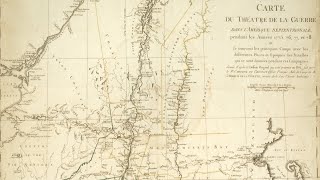
- Historical Programs Manager Andrew Outten discusses two maps produced by British cartographer William Faden depicting the Battle of Brandywine. William Faden is well known for his maps of major battles of the Revolutionary War. Unusually, he produced two maps of the Battle of Brandywine, one in 1778 and the other in 1784. Each map shows troop movements and positions along with other aspects of the overall battlefield landscape, but each conveys significantly different information. This Lunch Bite will focus on the Battle of Brandywine, the key differences between the two maps, and the potential reasons for the differences.
SUBSCRIBE to our channel: bit.ly/3DxZnrJ
Follow us on social media:
Facebook: / americanrevolutioninst...
Instagram: / americanrevolutioninst...
Twitter: / amrevinstitute
Stay updated by joining our mailing list: bit.ly/3TpfhdL
Become an Associate of the American Revolution Institute: bit.ly/3Bonuqp
Visit our website: www.americanrevolutioninstitute.org
Learn more and explore future and past programs: www.americanrevolutioninstitute.org/events
#amrevinstitute


You guys continue to hit the jackpot with me! Very interested in Brandywine!
19:26 bookmarking the Gazette reference for myself.